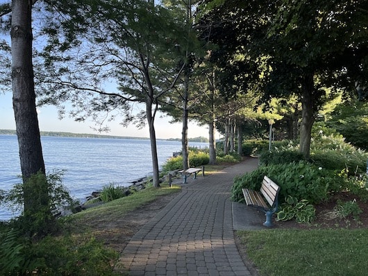
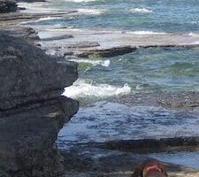
Brockville is a town of 21,000 located on the St. Lawrence River and is considered the eastern gateway to the Thousand Islands area in Ontario. One can put together a nice run combining paths along the waterfront and some small parks, most of it connected by the paved multi-use path called the Brock Trail. Includes the unique railroad tunnel trail!
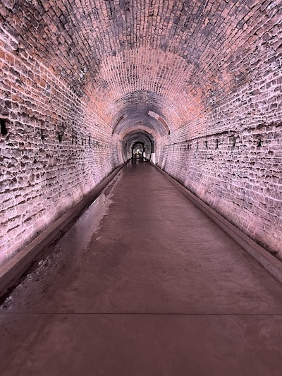
Railroad Tunnel. Photo: Mark Lowenstein
Start right downtown in Centeen Park. The first 2.5 km of the Brock Trail follows the path along the water and around the marina into Hardy Park (brief connection using Flint St.). Then continue Brock Trail inland for 3.5 km. It follows the outline of a creek, with the final 1 km through a series of three small parks. At the end, double back briefly to Central Ave. Turn LEFT, and then RIGHT on Park Ave., heading back south for ~1 km. At Victoria Park, RIGHT on Pearl Ave. to the entrance of the Railway Tunnel trail — an 0.5 underground trail in Canada’s first railway tunnel — which also has a fun sound and light show (note: can be slippery). Exit the south end and use Water St. to conclude the run.
Brockville is a town of 21,000 located on the St. Lawrence River and is considered the eastern gateway to the Thousand Islands area in Ontario. One can put together a nice run combining paths along the waterfront and some small parks, most of it connected by the paved multi-use path called the Brock Trail. Includes the unique railroad tunnel trail!
Railroad Tunnel. Photo: Mark Lowenstein
Start right downtown in Centeen Park. The first 2.5 km of the Brock Trail follows the path along the water and around the marina into Hardy Park (brief connection using Flint St.). Then continue Brock Trail inland for 3.5 km. It follows the outline of a creek, with the final 1 km through a series of three small parks. At the end, double back briefly to Central Ave. Turn LEFT, and then RIGHT on Park Ave., heading back south for ~1 km. At Victoria Park, RIGHT on Pearl Ave. to the entrance of the Railway Tunnel trail — an 0.5 underground trail in Canada’s first railway tunnel — which also has a fun sound and light show (note: can be slippery). Exit the south end and use Water St. to conclude the run.
Surrounded on three sides by the St. Lawrence River, Wellesley Island is one of the largest of the Thousand Islands. Lovely running in historic Thousand Island Park and some nice waterfront roads.
Nice running options in Clayton: Waterfront & attractive residential streets; Zenda Farms Preserve, which has lovely trails around pastureland & grassland; and the longer Rivergate Trestle Trail.
This cute town on the St. Lawrence River offers some nice waterfront running. Up to 6.8 miles out and back, with great river views. Interior farm roads a good add-on. Also the location of the Hope Ferry to Wolfe Island.
If you fancy some languid, flat, open running on nearly traffic-free farm roads, head to Wolfe Island. Accessible via ferry from Cape Vincent (NY) or Kingston (Ontario). Miles of pastoral roads for running.
The 6.7 mile loop around Point Salubrious is a lovely, flat run with great views of Guffin Bay and Chaumont Bay. The entire route is on the lightly trafficked Rt. 125. Water views, the Point Salubrious Historic District, farm fields.
A worth-it drive to Sackets Harbor to do a scenic run combining a nice waterfront road and trails around a historic battlefield, the site of an important battle in the War of 1812.
This 1,000-acre state park in Henderson is the former estate of Robert Wehle, and consists of 10 miles of wide, scenic trails along Lake Ontario, and around the estate grounds. We've mapped a 4.7 mile loop along the Snakefoot Trail.
Gananoque is the western gateway to the Thousand Islands area in Ontario. There's some nice running along the water, around pretty residential streets, and a 12 km trail system, with various loop options.
The 37 km paved multi-use trail along the Thousand Islands Parkway is a great running option in Thousand Islands NP. Some sections feature great water views. Also trail running at Landon Bay and Jones Creek Trails.
A great run on the Ontario side of the Thousand Islands. The Waterfront Trail runs for 9.4 km from Upper Canada Village to Ingleside, and the famous Long Sault Parkway features a wide shoulder and scenic views as it crosses 11 islands.
Share your feedback on this route and see that of other Great Runs users. Click on the image icon to upload a photo. And please let us know if there are notes or changes we should incorporate!

Review or Comment on This Route/Share a Photo!
Share your feedback on this route and see that of other Great Runs users. Click on the image icon to upload a photo. And please let us know if there are notes or changes we should incorporate!