This ‘runseeing’ tour of downtown Pittsburgh has a fantastic variety: parks, river paths, historic bridges, a hilltop promenade with great views, and the use of two, short incline railways! Overall, the tour is just shy of 7 miles, but there are shorter & longer options. Note: Have $5 in cash on hand for the funicular.
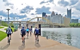
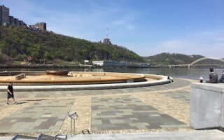
Start downtown around Market Square/Gateway Park. Run through Gateway Park to Point State Park, which sits a the confluence of the Monongahela & Ohio Rivers and features a fort, fountain, pedestrian bridge crossing under the highway. Loop around the park and then take the Three Rivers Heritage Trail alongside I-376 crossing the river (runnable, not that scenic).
Allegheny Commons Park. CC 2.0
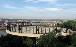
Use the short Duquesne Incline (funicular type railway) to access Grandview Ave. (it’s not so easy to get there otherwise). The next section is a scenic 1 mile along the Grandview promenade, featuring great views of the river & Pittsburgh skyline. At the east end of Grandview, take the Monongahela Incline down, and then the Smithfield Bridge back across the Monongahela River. Run along Smithfield St., LEFT on 6th Ave., RIGHT on 7th St. to access Allegheny Commons Park, a historic park featuring nice green space, sculptures, & paths. It’s a ~1.5 mile loop around the park. Conclude the run by using the Andy Warhol Bridge to return downtown.
Longer Option: Three Rivers Heritage Trail on the south side of the Monongahela River. Hillside [hiking] trails off Grandview Ave.
Shorter Option: Can eliminate Grandview section or
This ‘runseeing’ tour of downtown Pittsburgh has a fantastic variety: parks, river paths, historic bridges, a hilltop promenade with great views, and the use of two, short incline railways! Overall, the tour is just shy of 7 miles, but there are shorter & longer options. Note: Have $5 in cash on hand for the funicular.
Start downtown around Market Square/Gateway Park. Run through Gateway Park to Point State Park, which sits a the confluence of the Monongahela & Ohio Rivers and features a fort, fountain, pedestrian bridge crossing under the highway. Loop around the park and then take the Three Rivers Heritage Trail alongside I-376 crossing the river (runnable, not that scenic).
Allegheny Commons Park. CC 2.0
Use the short Duquesne Incline (funicular type railway) to access Grandview Ave. (it’s not so easy to get there otherwise). The next section is a scenic 1 mile along the Grandview promenade, featuring great views of the river & Pittsburgh skyline. At the east end of Grandview, take the Monongahela Incline down, and then the Smithfield Bridge back across the Monongahela River. Run along Smithfield St., LEFT on 6th Ave., RIGHT on 7th St. to access Allegheny Commons Park, a historic park featuring nice green space, sculptures, & paths. It’s a ~1.5 mile loop around the park. Conclude the run by using the Andy Warhol Bridge to return downtown.
Longer Option: Three Rivers Heritage Trail on the south side of the Monongahela River. Hillside [hiking] trails off Grandview Ave.
Shorter Option: Can eliminate Grandview section or
Scroll Down For Route Maps
Essentials
~6.8 miles (11 km). Note that the map shows longer on account of the Incline Railway
Rolling hills (note the elev gain reflects the Railways so is not accurate)
A fantastic run featuring the Grandview Promenade (uses the incline railway to access it), which offers great views of the Monongahela & Pittsburgh skyline. Loops back using the Three Rivers Heritage Trail. Can add with hillside trails.
The signature running option in Pittsburgh, with 33 miles of trail, along both banks of all three rivers in Pittsburgh. We've mapped & described the three main sections of the trail: Split District, North Side, & South Side, which can be mixed in various ways.
A classic Pittsburgh run along the Monongahela River between the Smithfield Bridge and the Hot Metal Bridge. Combines the more park-like south side of the river with the city's grittier north side. Good add-on options.
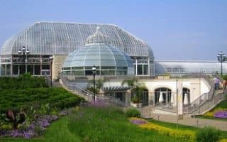
Three miles from downtown, there is great running near The University of Pittsburgh and Carnegie-Mellon University. A highlight is Schenley Park, with 456 acres of trails, the Phipps Conservatory and Botanical Gardens.
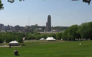
A great run combining two historic city parks: Schenley Park, with its botanical gardens, & more landscaped paths; and Frick Park, which has 400+ acres of mostly wooded trails. The lovely Squirrel Hill neighborhood connects the parks.
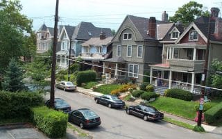
Create your own route on the side streets of these adjacent residential neighborhoods. Quieter, tree-lined streets with nice older homes and small commercial areas.
Historic park and neighborhood east of downtown that's wonderful for running. Highland Park features 4 miles of trails. including scenic lake loops. Combine with the leafy streets & Victorian homes in the historic district just south of the park.
Runners can get their heart rate up on Pittsburgh's famous hilly streets and stair paths! Canton Ave. at 37%, is the steepest street in North America. Several stair paths feature 300+ steps. We've mapped the steepest streets & longest stair paths.
Four parks/preserves north of Pittsburgh with easy running on mainly wooded trails. Highlights include the 5-mile North Park lake loop, the estate trails at Hartwood Acres, and the meadows & woods at Beechwood Farms Nature Preserve.
A good option near the airport. The Montour Trail runs 46 miles around the southwest part of Pitsburgh and to some of the neighboring communities. A connector trail to the airport was completed in 2012.
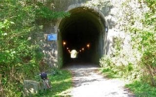
Downtown Pittsburgh is the start point of a popular long-distance rail-trail that runs for 150 miles to Cumberland, MD. The first view miles overlaps with the Three Rivers Heritage Trail. Wide, flat, gravel surfaced, & mainly wooded, with some nice river views.
A unique tour of Pittsburgh's downtown, Point State Park, and several neighborhoods, whose 11.5 mile route map is in the shape of a ballerina! Josh Key submitted this unique route along with a creative description.
Share your feedback on this route and see that of other Great Runs users. Click on the image icon to upload a photo. And please let us know if there are notes or changes we should incorporate!
Subscribe
0 Comments
Oldest
Newest
Inline Feedbacks
View all comments
Essentials
~6.8 miles (11 km). Note that the map shows longer on account of the Incline Railway
Rolling hills (note the elev gain reflects the Railways so is not accurate)


Review or Comment on This Route/Share a Photo!
Share your feedback on this route and see that of other Great Runs users. Click on the image icon to upload a photo. And please let us know if there are notes or changes we should incorporate!