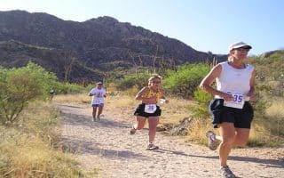
If you’re up for a hill challenge within walking distance from downtown, two adjacent peaks, with roads to leading to their summits, make for a fun challenge: Sentinel Peak & Tumamoc Hill. Do either or both!
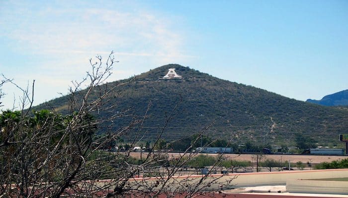
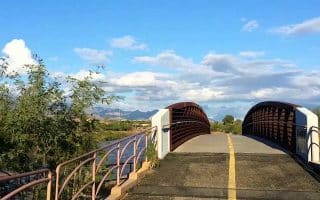
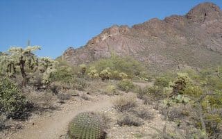
Sentinel Peak. Also known as “A Mountain” because it is painted annually by university students, this is on most runners’ to-do lists in Tucson! The climb is 500 feet over 1.5 miles, up to 6% grade. There is no sidewalk but there is a reasonable shoulder most of the way along Sentinel Peak Rd., and not too much traffic. There is a gazebo on top of the mountain. Start from the corner of Congress St. and Sentinel Peak Rd. One can also start closer to downtown (1 mile to the west) or the University (1.5 miles west). There’s a parking lot off Sentinel Rd. 0.5 miles south of Congress St.
Tumamoc Hill: Google Street Vie
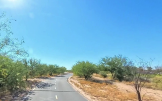
Tumamoc Hill. Part of the same area. This route starts off Silverbell Rd. It’s even more of a hill challenge, rising 730 feet over 1.6 miles to an Observatory at the summit. The narrow road does feature a pedestrian shoulder.
You can combine these two routes for a challenging double! The Tumamoc Hill trail is 0.7 miles west of the start of the Sentinel Peak trail, using Silverbell Rd.
If you’re up for a hill challenge within walking distance from downtown, two adjacent peaks, with roads to leading to their summits, make for a fun challenge: Sentinel Peak & Tumamoc Hill. Do either or both!
Sentinel Peak. Also known as “A Mountain” because it is painted annually by university students, this is on most runners’ to-do lists in Tucson! The climb is 500 feet over 1.5 miles, up to 6% grade. There is no sidewalk but there is a reasonable shoulder most of the way along Sentinel Peak Rd., and not too much traffic. There is a gazebo on top of the mountain. Start from the corner of Congress St. and Sentinel Peak Rd. One can also start closer to downtown (1 mile to the west) or the University (1.5 miles west). There’s a parking lot off Sentinel Rd. 0.5 miles south of Congress St.
Tumamoc Hill: Google Street Vie
Tumamoc Hill. Part of the same area. This route starts off Silverbell Rd. It’s even more of a hill challenge, rising 730 feet over 1.6 miles to an Observatory at the summit. The narrow road does feature a pedestrian shoulder.
You can combine these two routes for a challenging double! The Tumamoc Hill trail is 0.7 miles west of the start of the Sentinel Peak trail, using Silverbell Rd.
Scroll Down For Route Maps
Essentials
Sentinel Peak: 3.2 miles (5.1 km) out & back. Tumamoc Hill: 3.2 miles (5.1 km) out & back. It's 0.7 miles along Silverbell Rd. between the two trailheads
Sentinel Peak 500 feet. Tumamoc Hill: 730 feet
Senintel Peak: Congress St.& Sentinel Peak Rd (Downtown is 1 mile to the west). Tumamoc Hill trailhead is off Silverbell Rd/
Good opportunity for a long distance off-road run near downtown. Paved multi-use path extend for nearly 14 miles along both banks of the (mainly dry) Santa Cruz River. Gradual downhill headed north, uphill headed south.
A 3.2 mile tour of the main University of Arizona campus. Some of the campus highlights and surrounding roads. Can be added with nearby downtown roads.
Centrally located park downtown, with popular running loops on paved paths, an 800 meter dirt track, lit at night, and even a drop-in running group that's been around for 20 years.
This route won't win any awards for beauty, but is a good off-road option near downtown. Paved multi-use trail runs for up to 7 miles southeast from downtown, following Barraza-Aviation Parkway & Golf Links Rd.
A great running spot located in the foothills in Northern Tucson. The trail follows the Rillito River for 12 miles, passing through three parks. There are paths along both banks. Lots of options for loops! Nice landscaping and some shade in parts.
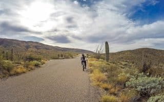
Popular national park near Tucson featuring the largest cacti in the United States, mountains, and stunning desert scenery. This post is focused on the best trail running options in 'Park East', in the Rincon Mountains. See also 'Park West' guide.
The 'Park West' section of Saguaro NP, 17 miles west of Tucson. 40 miles of scenic trail running in desert scrub, desert grassland, mountains, & canyons. We recommend some of the easier roads & trails for running. See also 'Park East'.
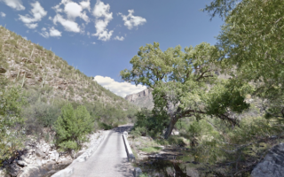
A section of the Coronado National Forest. Run on a 3.8 mile paved trail, passing through a narrow valley with a wadable stream, cacti, flowers and boulders -- and climbing 1,000 feet! Additional, more rugged trail options.
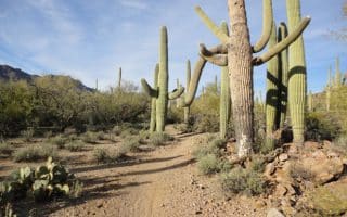
A trail running location and a great opportunity to experience Sonoran Desert terrain near downtown. 14 miles of trails over 894 acres, ranging from easier to more challenging.
There are wonderful, open trails in Tucson Mountain Park, a ten minute drive east of Tucson. Numerous options here --many of them more modest for trail running, including the 4.7 mile Starr Pass Trail Loop. Great views, and especially lovely at sunrise & sunset.
Wonderful state park 17 miles north of Tuscon with extensive trail system through mesquite forests and saguaro-studded canyons, and fantastic views of the Catalina Mountains. Trails range from easy to challenging.
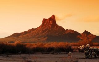
Beautiful running opportunity in the Sonoran Desert, located 40 minutes from Tuscon. Trail running ranging from easy to challenging. Great views of desert scenery, Picacho Peak, and famous for wildflowers in season.
Share your feedback on this route and see that of other Great Runs users. Click on the image icon to upload a photo. And please let us know if there are notes or changes we should incorporate!
Subscribe
0 Comments
Oldest
Newest
Inline Feedbacks
View all comments
Essentials
Sentinel Peak: 3.2 miles (5.1 km) out & back. Tumamoc Hill: 3.2 miles (5.1 km) out & back. It's 0.7 miles along Silverbell Rd. between the two trailheads
Sentinel Peak 500 feet. Tumamoc Hill: 730 feet
Senintel Peak: Congress St.& Sentinel Peak Rd (Downtown is 1 mile to the west). Tumamoc Hill trailhead is off Silverbell Rd/


Review or Comment on This Route/Share a Photo!
Share your feedback on this route and see that of other Great Runs users. Click on the image icon to upload a photo. And please let us know if there are notes or changes we should incorporate!