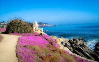
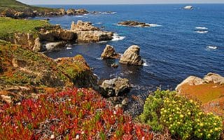
A great variety of scenic running options are available in this small coastal city located 40 miles north of the Monterey/Carmel area. While the downtown boardwalk area is remarkably festive (think ferris wheels and funnel cakes), local runners agree the best places to run in Santa Cruz are the bike path along West Cliff Drive and the seaside trails of the Wilder Ranch State Park. We also love the Santa Cruz Riverwalk, the fantastic and varied paths on the campus of UC Santa Cruz, great beach running on Seacliff State Beach, and the fire road and trails through a redwood forest in The Forest of Nisene Marks State Park.
All Santa Cruz Area Routes
Wikimedia Commons
Scroll Down For Route Maps
More Monterey/Carmel/Big Sur, CA Routes BelowCurrent Weather & Forecast

Monterey, US
3:03 am,
Jul 14, 2026
L: 16°
H: 16°
Daily ForecastHourly Forecast
Today
2:00 pm
30° / 36°°C
0 mm
0%
10 mph
42 %
1016 mb
0 mm/h
Tomorrow
2:00 pm
22° / 33°°C
0.93 mm
93%
13 mph
75 %
1018 mb
0 mm/h
Thursday
2:00 pm
20° / 35°°C
1 mm
100%
14 mph
88 %
1018 mb
0 mm/h
Friday
2:00 pm
20° / 26°°C
1 mm
100%
11 mph
84 %
1015 mb
0 mm/h
Saturday
2:00 pm
18° / 29°°C
0 mm
0%
10 mph
66 %
1019 mb
0 mm/h
Today
5:00 am
32° / 33°°C
0 mm
0%
3 mph
42 %
1016 mb
0 mm/h
Today
8:00 am
34° / 36°°C
0 mm
0%
4 mph
28 %
1015 mb
0 mm/h
Today
11:00 am
34° / 34°°C
0 mm
0%
6 mph
21 %
1014 mb
0 mm/h
Today
2:00 pm
30° / 30°°C
0 mm
0%
10 mph
32 %
1016 mb
0 mm/h
Today
5:00 pm
27° / 27°°C
0 mm
0%
7 mph
37 %
1016 mb
0 mm/h
Today
8:00 pm
24° / 24°°C
0.83 mm
83%
6 mph
59 %
1016 mb
0 mm/h
Today
11:00 pm
22° / 22°°C
0.93 mm
93%
7 mph
75 %
1017 mb
0 mm/h
Other Routes in Monterey/Carmel/Big Sur, CA
The Monterey Bay Coastal Recreation Trail spans the coast of Monterey between Pacific Grove and Castroville. The former railway is now a wide, 18-mile multi-use path featuring a variety of spectacular scenery and some of the area's key attractions.
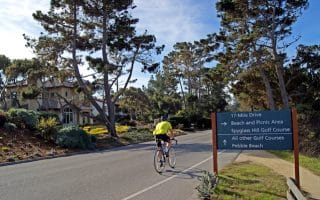
11 mile seaside road between Carmel and Monterey. Wonderful views. It's possible to run along the entire road, but the section with the widest shoulder and great views is 4 miles between Cypress Point and Asilomar.
For a quick access beach run just outside Carmel, look no further than Asilomar State Beach, a local favorite for a roughly two mile out and back with amazing coastal views.
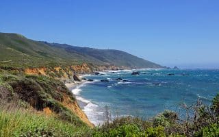
Big Sur is one of the most spectacular gems of the California Coast, and the views are at their best from the Panorama Trail in Andrew Molera State Park, 22 miles south of Carmel.
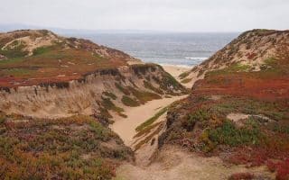
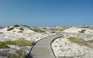
State Park has a 1,500 foot trail to 4 miles of ocean beach with beautiful views of Monterey Bay. Gorgeous dunes. Several miles of roads and trails in the park that are good for running and cycling. The beach is also runnable.
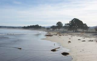
If you favor running on sand, the uninterrupted stretch of beach between Del Monte Beach and Moss Landing is a great route for a roughly 2.5 mile out and back on nothing but gently graded pristine white sands.
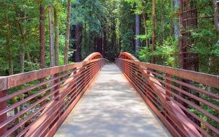
One of the great runs anywhere: Combine the fab ocean views and incredible homes along 2-mile Scenic Road with the charming Golden Rectangle neighborhood and trails through redwoods in Mission Trail Park. Carmel Beach also runnable.
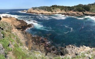
Point Lobos is a popular spot for good reason — it’s one of the most scenic public locations along the length of Big Sur. The Perimeter Loop, which covers about 4.5 miles of the park’s most scenic trails, is in great condition for running.
The highest point along the Monterey Peninsula, Jacks Peak is the go-to trail run for locals who want to skip the busier tracks along the coast and still get in some killer views. 500 acres, 8 miles of trails. Hilly but not too technical.
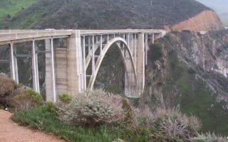
The Old Coast Road is a beautiful dirt track which covers about 10 miles from Andrew Molera State Park in the south to what is now the Bixby Bridge. Fantastic views. Hilly. It's a great alternative to Rt. 1, which is not safe for running.
1,000 acre state park is heart of Big Sur.Wonderful trail running, with excellent variety, from coastal forest to oceanside views. Currently, the best open trail is Buzzard’s Roost Trail, a moderate three miles loop from the Cabrillo Highway.
User Ratings
Leave A Review or Comment
Review or Comment on This Route/Share a Photo!
Share your feedback on this route and see that of other Great Runs users. Click on the image icon to upload a photo. And please let us know if there are notes or changes we should incorporate!