Tralee is the largest town in County Kerry, with a whopping population of 23,000! There are some nice running options in Tralee, including a flat off-road path along the Tralee Canal, paths around the beautiful Park of Tralee, and the recently completed Tralee-Fenit Greenway. These three options are all within 1 km of each other, so can be combined! Tralee is also the official start/end point of the Dingle Way Trail long-distance walking path.
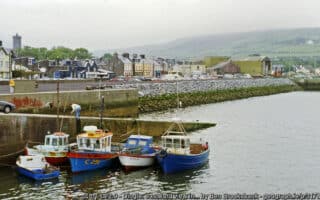
Tralee Canal Walk. CC: Humphrey Bolton
Tralee Canal Walk. One of the best opportunities in County Kerry for a flat off-road run. This gravel path follows the north bank of the Canal for 2.7 km, then turns north and follows Cockleshell Beach for another 1 km. Overall, up to 3.6 km one-way. Nice views of the mountains heading west toward the sea. ROUTE MAP
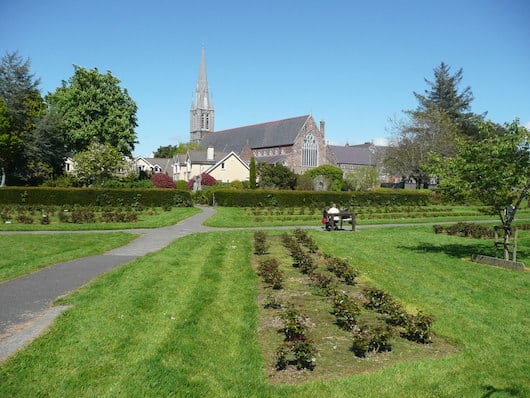
Park of Tralee. A particularly nice park for a relatively small town. 3-4 km of beautifully landscaped paths — a Rose Garden, County Kerry Museum, and a performing arts center. A loop of the perimeter path is ~1.5 km. Near the town center, use Denny St. Can combine with Canal path, which is just 0.5 km west of the park.
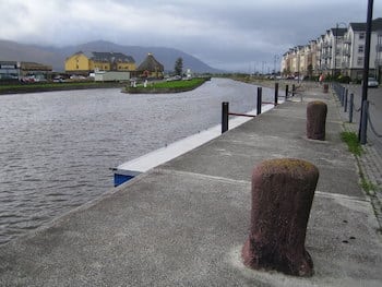
Tralee-Fenit Greenway. This greenway is a new and wonderful addition to the running scene in the Tralee area. The paved multi-use trail covers nearly 15 km between Tralee and Fenit. It is mainly inland, passing by open fields and farms.
Tralee to Fenit Greeway. GSV
In Tralee, the path starts right across from the train station. Run north for ~3 km, and then head east toward Fenit, passing through Knockanish, Lassinagh, Cotters Bend, & Talaught. In Fenit, we’ve added the sort path that goes to the tip, with splendid views of Tralee Bay. In Fenit, there’s a scenic pier out to the Saint Brendan The Navigator Monument that makes for a scenic 1/2 mile jaunt. ROUTE MAP. TRAIL INFORMATION
Tralee is the largest town in County Kerry, with a whopping population of 23,000! There are some nice running options in Tralee, including a flat off-road path along the Tralee Canal, paths around the beautiful Park of Tralee, and the recently completed Tralee-Fenit Greenway. These three options are all within 1 km of each other, so can be combined! Tralee is also the official start/end point of the Dingle Way Trail long-distance walking path.
Tralee Canal Walk. CC: Humphrey Bolton
Tralee Canal Walk. One of the best opportunities in County Kerry for a flat off-road run. This gravel path follows the north bank of the Canal for 2.7 km, then turns north and follows Cockleshell Beach for another 1 km. Overall, up to 3.6 km one-way. Nice views of the mountains heading west toward the sea. ROUTE MAP
Park of Tralee. A particularly nice park for a relatively small town. 3-4 km of beautifully landscaped paths — a Rose Garden, County Kerry Museum, and a performing arts center. A loop of the perimeter path is ~1.5 km. Near the town center, use Denny St. Can combine with Canal path, which is just 0.5 km west of the park.
Tralee-Fenit Greenway. This greenway is a new and wonderful addition to the running scene in the Tralee area. The paved multi-use trail covers nearly 15 km between Tralee and Fenit. It is mainly inland, passing by open fields and farms.
Tralee to Fenit Greeway. GSV
In Tralee, the path starts right across from the train station. Run north for ~3 km, and then head east toward Fenit, passing through Knockanish, Lassinagh, Cotters Bend, & Talaught. In Fenit, we’ve added the sort path that goes to the tip, with splendid views of Tralee Bay. In Fenit, there’s a scenic pier out to the Saint Brendan The Navigator Monument that makes for a scenic 1/2 mile jaunt. ROUTE MAP. TRAIL INFORMATION
Scroll Down For Route Maps
Essentials
All three routes are easily accessible from the Town Center.
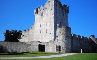
For a nice off-road run in Killarney, there's a series of footpaths heading southwest to Ross Castle and then out to Library Point. Mainly paved, with a landscape alternating between open fields, some views of the River Deenagh, and wooded sections.
There's something for every runner in this 26,000-acre park known for its combination of mountains, lakes, woods and waterfalls under ever changing skies. Easier running includes routes exploring Killarney House, Ross Castle/Ross Island, Muckross House.
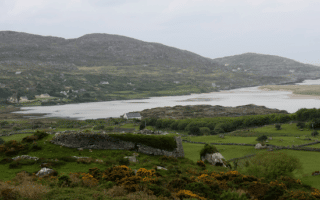
This running tour of Kenmare's highlights has a nice variety. Historic Cromwell's Bridge, Kenmare Stone Circle, nice water views along the Kenmare Pier and over the Kenmare Bridge, and the famous rhododendron tunnel trail in Reenagross Woodland.
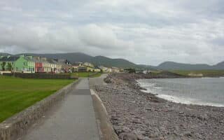
Just off the Ring of Kerry in Waterville, a nice run on quieter roads that mixes a waterfront section along Ballinskelligs Bay, then a 5.6 km interior loop featuring the Loher Stone Fort. The full route is a 10-miler, but there are shorter/longer options.
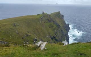
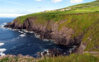
Gorgeous clifftop trail run of moderate challenge on Valentia Island, set location for Star Wars: The Force Awakens. Decent surface on the steady climb to the Bray Head Watchtower, with great views out to the Skellig Islands.
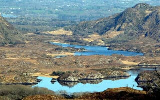
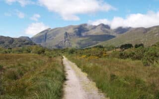
Heaven for trail runners! Choose a section of this 200 km walking trail around the Iveragh Peninsula. There are easy, moderate, and difficult sections. Much of the trail is on clifftop heads above the water, with some interior farmland sections.
The Dingle peninsula is a popular visitor destination in County Kerry, known for its rugged scenery, trails, and sandy beaches. There's a nice waterfront run in Dingle, good beach running at Carthoo Beach, and a gorgeous clifftop trail run at Slay Head.
Another great option for trail runners! Choose a section of this 179 km walking trail around the Dingle Peninsula. Trail running with various degrees of difficulty, & somewhat easier than the Kerry Way. Much of the trail is along or above the coast.
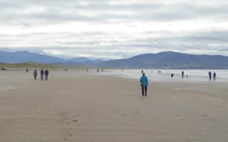
There are some wonderful beaches for running in County Kerry -- wide, with firm sand. Inch Beach, Ceann Trá, and Stradbelly Beach are on the Dingle Peninsula, while Rossbeigh Strand is just off the Ring of Kerry.
Share your feedback on this route and see that of other Great Runs users. Click on the image icon to upload a photo. And please let us know if there are notes or changes we should incorporate!
Subscribe
0 Comments
Oldest
Newest
Inline Feedbacks
View all comments
Essentials
All three routes are easily accessible from the Town Center.


Review or Comment on This Route/Share a Photo!
Share your feedback on this route and see that of other Great Runs users. Click on the image icon to upload a photo. And please let us know if there are notes or changes we should incorporate!