Amelia Island and its main city of Fernandina Beach are located just 40 minutes north of Jacksonville on a beautiful barrier beach between the Amelia River and the Atlantic ocean. This vacation destination is popular among Florida locals and tourists alike for its laid back beach vibes blended with southern charm. Keeping the May-October hot and humid Florida weather in mind, there is plenty of great running on Amelia Island. Some of the best places to run on Amelia Island are the 13 miles of public beach, numerous bike paths, Fort Clinch State Park, and miles of scenic sidewalks through the residences and shops of bubbly downtown Fernandina Beach. South of Amelia Island, use the scenic Crady pedestrian bridge over Nassau sound to connect to the 8-mile Timucuan Trail, which travels south through Big Talbot Island & Little Talbot Island, with connections to additional trails and scenic beaches.
Patty O’Hearn Kickham
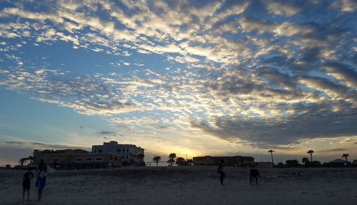
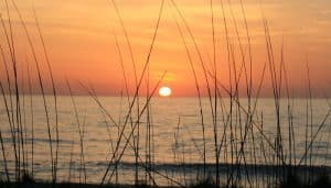
Fernandina Beach: The coast of Amelia Island is lined by 13 miles of perfect running sand — firm, flat, and wide, with plenty of access points and parking off South Fletcher Ave so you can hop on and off for a run of any length. Like all beach running, conditions are best at low tide. MAP
South Fletcher Ave: The stretch of South Fletcher Ave. (A1A) along Fernandina Beach is an excellent run either on its own or in combination with a run of the sand. A nice flat sidewalk spans most of the street, which is lined with elegant waterfront homes. The best section is north of the intersection with Sadler Road (108) to the Main Beach Park, which is about 2 miles one-way. There are occasional water views, but the ocean side is generally lined with homes. TRAIL MAP
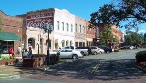
Downtown / Atlantic Ave: Historic downtown Fernandina Beach is an adorable collection of restaurants and shops around Centre Street and Front Street on the northwest shore of the island. The brick sidewalks, shaded by Spanish moss covered trees, are incredibly inviting — just watch out for strolling pedestrians in this busy section of town. Create your own route, weaving in and out of the residential side streets off Centre St., or run the 2 miles east along Centre St./Atlantic Ave., to the Main Beach Park. Shaded and very pleasant with nice homes. MAP
Egans Creek Greenway. raygoose99
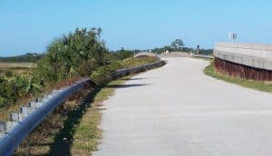
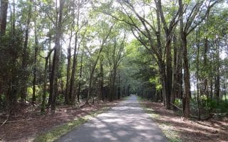
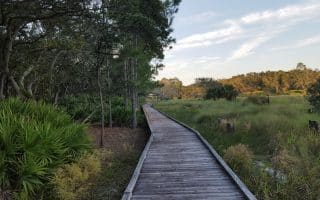
Egans Creek Greenway: This great section of the Florida Birding Trail is set on 300 acres of conservation land bordering scenic Egans Creek. The grass trail network is about 5 miles total, mostly out and back with some short looping sections. It’s a great opportunity to see wildlife and flora in a thriving coastal swamp. Park at the Atlantic Recreation Center, where you can amp up your workout with stationary exercise equipment. TRAIL MAP & INFO
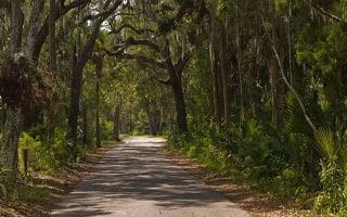
Fort Clinch State Park: The northern tip of Amelia Island is conserved by Fort Clinch State Park, a 19th century brick fortress from the Seminole Wars. This park is a favorite spot for running, with a 6 mile shared use trail that circles the park with access to the fort and a 3 mile beach over a path lined with Spanish moss draped oaks. TRAIL MAP & INFO
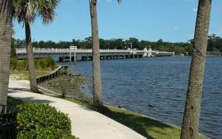
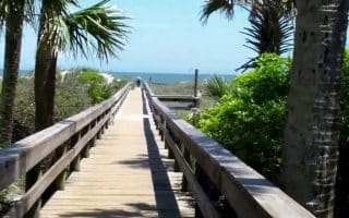
Amelia Island Trail: Part of the East Coast Greenway, the Amelia Island Trail is a paved multi-use path which spans 7 miles between Peters Point Beachfront Park and Big Talbot Island State Park. The trail follows A1A in its own lane, so there is some car noise, but it’s a reliable route on the remote south side of the island. It’s 6 miles to Amelia Island State Park. At the south end of the Amelia Island Trail is the George Crady Bridge Fishing Pier State Park, which features a splendid 1-mile pedestrian bridge over Nassau Sound, connecting Amelia Island to Big Talbot Island. Great water views! On Big Talbot Island, connect to the Timucuan Trail (below). TRAIL MAP & INFO
Timucuan Trail. From the north end of Big Talbot Island, the paved Timucuan Trail runs for 8+ miles south to the Fort George River. The trail parallels the Jimmy Buffet Memorial Hwy, though for much of the way, it’s separated from the road by a thicket of trees. The north end is a scenic wooden boardwalk section at Spoonbill Park, a premier birding spot (you might see the pink plumage of the roseate spoonbill!). Continue south through a maritime hammock forest, with connections to the Bluffs Shoreline Trail or Blackrock Trail to access the famous Boneyard Beach, where magnificent giant skeletons of live oak, cedar and pine trees crowd the surreal battered shoreline. NEW: Recently completed section over the salt march connects to Little Talbot Island State Park, where the trail continues through a rustic dunescape to overlook the Fort George River at the south end of the island. There are plans to extend the Timucuan Trail for another 6 miles south to Hanna Park in Jacksonville. ROUTE MAP
Amelia Island Parkway: This separated bike lane bordering the Amelia Island Parkway serves as a cutoff along the Amelia Island Trail, from Peters Point Beach to American Beach. There is some traffic along this stretch, but also lots of nice parks, fancy hotels, and beach access. 1.75 miles one-way. MAP
Amelia Island and its main city of Fernandina Beach are located just 40 minutes north of Jacksonville on a beautiful barrier beach between the Amelia River and the Atlantic ocean. This vacation destination is popular among Florida locals and tourists alike for its laid back beach vibes blended with southern charm. Keeping the May-October hot and humid Florida weather in mind, there is plenty of great running on Amelia Island. Some of the best places to run on Amelia Island are the 13 miles of public beach, numerous bike paths, Fort Clinch State Park, and miles of scenic sidewalks through the residences and shops of bubbly downtown Fernandina Beach. South of Amelia Island, use the scenic Crady pedestrian bridge over Nassau sound to connect to the 8-mile Timucuan Trail, which travels south through Big Talbot Island & Little Talbot Island, with connections to additional trails and scenic beaches.
Patty O’Hearn Kickham
Fernandina Beach: The coast of Amelia Island is lined by 13 miles of perfect running sand — firm, flat, and wide, with plenty of access points and parking off South Fletcher Ave so you can hop on and off for a run of any length. Like all beach running, conditions are best at low tide. MAP
South Fletcher Ave: The stretch of South Fletcher Ave. (A1A) along Fernandina Beach is an excellent run either on its own or in combination with a run of the sand. A nice flat sidewalk spans most of the street, which is lined with elegant waterfront homes. The best section is north of the intersection with Sadler Road (108) to the Main Beach Park, which is about 2 miles one-way. There are occasional water views, but the ocean side is generally lined with homes. TRAIL MAP
Downtown / Atlantic Ave: Historic downtown Fernandina Beach is an adorable collection of restaurants and shops around Centre Street and Front Street on the northwest shore of the island. The brick sidewalks, shaded by Spanish moss covered trees, are incredibly inviting — just watch out for strolling pedestrians in this busy section of town. Create your own route, weaving in and out of the residential side streets off Centre St., or run the 2 miles east along Centre St./Atlantic Ave., to the Main Beach Park. Shaded and very pleasant with nice homes. MAP
Egans Creek Greenway. raygoose99
Egans Creek Greenway: This great section of the Florida Birding Trail is set on 300 acres of conservation land bordering scenic Egans Creek. The grass trail network is about 5 miles total, mostly out and back with some short looping sections. It’s a great opportunity to see wildlife and flora in a thriving coastal swamp. Park at the Atlantic Recreation Center, where you can amp up your workout with stationary exercise equipment. TRAIL MAP & INFO
Fort Clinch State Park: The northern tip of Amelia Island is conserved by Fort Clinch State Park, a 19th century brick fortress from the Seminole Wars. This park is a favorite spot for running, with a 6 mile shared use trail that circles the park with access to the fort and a 3 mile beach over a path lined with Spanish moss draped oaks. TRAIL MAP & INFO
Amelia Island Trail: Part of the East Coast Greenway, the Amelia Island Trail is a paved multi-use path which spans 7 miles between Peters Point Beachfront Park and Big Talbot Island State Park. The trail follows A1A in its own lane, so there is some car noise, but it’s a reliable route on the remote south side of the island. It’s 6 miles to Amelia Island State Park. At the south end of the Amelia Island Trail is the George Crady Bridge Fishing Pier State Park, which features a splendid 1-mile pedestrian bridge over Nassau Sound, connecting Amelia Island to Big Talbot Island. Great water views! On Big Talbot Island, connect to the Timucuan Trail (below). TRAIL MAP & INFO
Timucuan Trail. From the north end of Big Talbot Island, the paved Timucuan Trail runs for 8+ miles south to the Fort George River. The trail parallels the Jimmy Buffet Memorial Hwy, though for much of the way, it’s separated from the road by a thicket of trees. The north end is a scenic wooden boardwalk section at Spoonbill Park, a premier birding spot (you might see the pink plumage of the roseate spoonbill!). Continue south through a maritime hammock forest, with connections to the Bluffs Shoreline Trail or Blackrock Trail to access the famous Boneyard Beach, where magnificent giant skeletons of live oak, cedar and pine trees crowd the surreal battered shoreline. NEW: Recently completed section over the salt march connects to Little Talbot Island State Park, where the trail continues through a rustic dunescape to overlook the Fort George River at the south end of the island. There are plans to extend the Timucuan Trail for another 6 miles south to Hanna Park in Jacksonville. ROUTE MAP
Amelia Island Parkway: This separated bike lane bordering the Amelia Island Parkway serves as a cutoff along the Amelia Island Trail, from Peters Point Beach to American Beach. There is some traffic along this stretch, but also lots of nice parks, fancy hotels, and beach access. 1.75 miles one-way. MAP
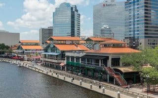
The Riverwalk is the running highlight of downtown Jacksonville, with 2 miles of paths on the north bank and 1 mile on the south bank of the St. Johns River, connected by the Main St. Bridge and Acosta Bridge. Stadium loop is 2.5 mile add-on.
Another option for a downtown run, incorporating trendy San Marco Square, an upscale residential district, two bridges, and a section of the Riverwalk Path. Add on or combine with Riverwalk.
The Ortega neighborhood is bordered by the St. Johns River on the East, the Cedar River on the North, and the Ortega river on the West, practically making it an "inland island."
This diverse neighborhood reveals part of Jacksonville’s rich cultural diversity. A great run for hot days as it provides lots of shade & you can find the perfect fit gear at 1st Place Sports while you’re at it!
The Jacksonville-Baldwin Trail is 14.5 miles long and runs from Jacksonville’s westside to the small town of Baldwin. The trail is great for running as the surface is entirely asphalt.
The Theodore Roosevelt Preserve covers 600 acres adjacent to the Fort Caroline National Memorial. The trails offer a lot of elevation, with some of the steepest hills you will find in the area.
Hanna Park is a 450 acre park located oceanfront just north of Atlantic Beach. With cool ocean breezes along the way and a plunge in the surf after your run, this park is ideal for one of the hot days!
One of the best off-road courses in the Jacksonville Area, these are easy trails through terrain ranging from sandhill to lush floodplain swamp and marshes. Blazed loops of 3.9 and 6.1 miles.
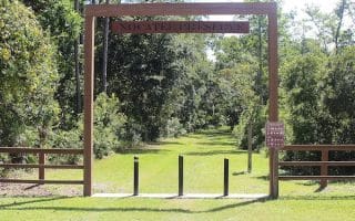
A master planned community, between St. Augustine and Jacksonville. Great running on the 10+ miles of 'fitness trails' around the 5,000 acres of village-like neighborhoods. Or run on the lovely 3.5-mile Nature Trail of the nearby Nocatee Nature Preserve.
The Perfect 10 got its name not for it's beauty or terrain, but because it was measured several times. Although it is also one of the most scenic runs in Jacksonville!
Share your feedback on this route and see that of other Great Runs users. Click on the image icon to upload a photo. And please let us know if there are notes or changes we should incorporate!
 Downtown / Atlantic Ave: Historic downtown Fernandina Beach is an adorable collection of restaurants and shops around Centre Street and Front Street on the northwest shore of the island. The brick sidewalks, shaded by Spanish moss covered trees, are incredibly inviting — just watch out for strolling pedestrians in this busy section of town. Create your own route, weaving in and out of the residential side streets off Centre St., or run the 2 miles east along Centre St./Atlantic Ave., to the Main Beach Park. Shaded and very pleasant with nice homes. MAP
 Amelia Island Trail: Part of the East Coast Greenway, the Amelia Island Trail is a paved multi-use path which spans 7 miles between Peters Point Beachfront Park and Big Talbot Island State Park. The trail follows A1A in its own lane, so there is some car noise, but it’s a reliable route on the remote south side of the island. It’s 6 miles to Amelia Island State Park. At the south end of the Amelia Island Trail is the George Crady Bridge Fishing Pier State Park, which features a splendid 1-mile pedestrian bridge over Nassau Sound, connecting Amelia Island to Big Talbot Island. Great water views! On Big Talbot Island, connect to the Timucuan Trail (below). TRAIL MAP & INFO


Review or Comment on This Route/Share a Photo!
Share your feedback on this route and see that of other Great Runs users. Click on the image icon to upload a photo. And please let us know if there are notes or changes we should incorporate!