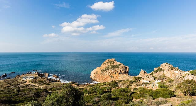
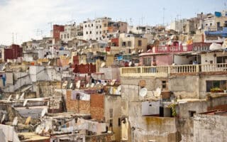
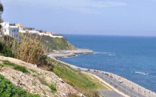
For a scenic and hilly running (or walking/hiking) experience, we highly recommend a visit to Cap Spartel. Located 14 km from Tangier, Cap Spartel is the most northwestern point in Africa and is where the North Atlantic and Mediterranean meet. It overlooks the Strait of Gibraltar and features fantastic views of the sea and green coastline. Especially pretty at sunset! Note: the area is exposed and hilly.
Cap Spartel. Google Street View
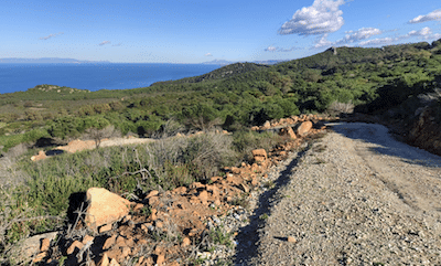
For running, there’s an extensive network of low-trafficked minor roads and gravel paths/roads. Be sure to include the 1 km Promenade Cap Spartel, near the beach/parking lot. There are also more rugged hiking trails that are popular for trail running. We don’t recommend running on the main road going through Cap Spartel, as it’s busy and doesn’t have a great shoulder. Unfortunately, there’s not a good digital road/trail map of the area. It’s ~7-8 km from one end of Cap Spartel to the other.
At sea level, there’s the gorgeous Achakkar Beach, which leads to the Cave of Hercules.
Add-On/Alternative: There are many additional trails for running in this area. Adjacent to Cape Spartel is Mediouna Park, which has forested trails. And across the Mediouna Access Road is a large network of more rugged trails in the Terrain Kachkach, a popular hiking area. Combination of open & wooded landscape. Many of the trails are more rugged and rocky.
For a scenic and hilly running (or walking/hiking) experience, we highly recommend a visit to Cap Spartel. Located 14 km from Tangier, Cap Spartel is the most northwestern point in Africa and is where the North Atlantic and Mediterranean meet. It overlooks the Strait of Gibraltar and features fantastic views of the sea and green coastline. Especially pretty at sunset! Note: the area is exposed and hilly.
Cap Spartel. Google Street View
For running, there’s an extensive network of low-trafficked minor roads and gravel paths/roads. Be sure to include the 1 km Promenade Cap Spartel, near the beach/parking lot. There are also more rugged hiking trails that are popular for trail running. We don’t recommend running on the main road going through Cap Spartel, as it’s busy and doesn’t have a great shoulder. Unfortunately, there’s not a good digital road/trail map of the area. It’s ~7-8 km from one end of Cap Spartel to the other.
At sea level, there’s the gorgeous Achakkar Beach, which leads to the Cave of Hercules.
Add-On/Alternative: There are many additional trails for running in this area. Adjacent to Cape Spartel is Mediouna Park, which has forested trails. And across the Mediouna Access Road is a large network of more rugged trails in the Terrain Kachkach, a popular hiking area. Combination of open & wooded landscape. Many of the trails are more rugged and rocky.
Essentials
Depends on route chosen. It's 7-8 km from one end to the other.
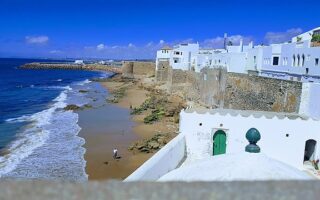
Asilah is a great spot for a visit and a destination run! Enjoy a 6 km 'runseeing' tour featuring a waterfront promenade, park, and a section along the 15-century rampart and through the historic Medina.
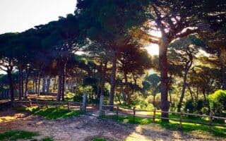
Great spot for running just west of Tangier. Wooded park featuring several km of trails through a Mediterranean landscape on a combination of wide dirt paths and some more rugged options. There are some great sea views.
Get up early to run the narrow streets and alleys of the Ancien Medina. We've mapped an outline route around Tangier's historic highlights: Medina, ancient gates, Bab Bhar Stairs, Mendoubia Garden, Merkala Garden, Marshan Park, & more.
The waterfront promenade is the signature run in Tangier. One can run for 8.5 km along the water, enjoying great sea views. There are 5 km on a wide sidewalk along Ave. Mohammed VI and 3.5 km along Route de la Plage, which isa more scenic, dedicated path.
Share your feedback on this route and see that of other Great Runs users. Click on the image icon to upload a photo. And please let us know if there are notes or changes we should incorporate!
Subscribe
0 Comments
Oldest
Newest
Inline Feedbacks
View all comments
Essentials
Depends on route chosen. It's 7-8 km from one end to the other.

Review or Comment on This Route/Share a Photo!
Share your feedback on this route and see that of other Great Runs users. Click on the image icon to upload a photo. And please let us know if there are notes or changes we should incorporate!