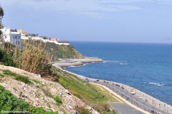
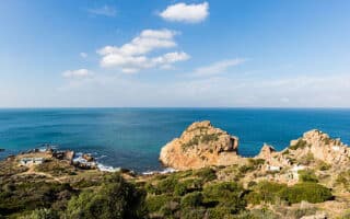
The waterfront promenade is the signature run in Tangier. One can run for 8.5 km along the water, enjoying great views of the Mediterranean/Strait of Gibraltar/North Atlantic. There are two ‘sections’: Ave. Mohammed VI and Route de la Plage. We prefer the Route de la Plage Merkala.
Ave. Mohammed VI Section: 5 km. The east end starts at Villa Harris Park. There’s a wide sidewalk along Ave. Mohammed VI, in the more modern Tangier City Center, with views of the water much of the way. There are some spots where buildings block the view. Note that Ave. Mohammed VI is a major road with several lanes of traffic, so it’s not quiet and bucolic. The first 2 km are along Plage de Tanger (plage=beach)/Plage Muncipale. At the 2 km mark, there’s more of a dedicated path through Corniche Gardens and along the Marina. It’s 5 km to the Dar Al-Baroud Tower.
Add-On: Run the 800m jaunt down the marina pier
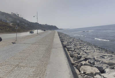
Route de la Plage Merkala. Google Street View
Route de la Plage Merkala. 3.5 km. This section is quieter and more of a dedicated waterfront path. The wide, brick-surfaced path follows Route de la Plage Merkala for 3 km from Dar Al-Baroud Tower west to Merkala Garden. There are great views and a festive scene. From Merkala Garden, you can curl inland a bit and continue along a dirt path for another 0.5 km.
Add-On: At the Merkala Garden at the west end, can run inland on its paths to the small, nicely landscaped Marshan Park. Then head west to the Marshan Palace — pretty grounds!
Note: The beaches along the route are beautiful but they aren’t great for running — sand isn’t very firm.
The waterfront promenade is the signature run in Tangier. One can run for 8.5 km along the water, enjoying great views of the Mediterranean/Strait of Gibraltar/North Atlantic. There are two ‘sections’: Ave. Mohammed VI and Route de la Plage. We prefer the Route de la Plage Merkala.
Ave. Mohammed VI Section: 5 km. The east end starts at Villa Harris Park. There’s a wide sidewalk along Ave. Mohammed VI, in the more modern Tangier City Center, with views of the water much of the way. There are some spots where buildings block the view. Note that Ave. Mohammed VI is a major road with several lanes of traffic, so it’s not quiet and bucolic. The first 2 km are along Plage de Tanger (plage=beach)/Plage Muncipale. At the 2 km mark, there’s more of a dedicated path through Corniche Gardens and along the Marina. It’s 5 km to the Dar Al-Baroud Tower.
Add-On: Run the 800m jaunt down the marina pier
Route de la Plage Merkala. Google Street View
Route de la Plage Merkala. 3.5 km. This section is quieter and more of a dedicated waterfront path. The wide, brick-surfaced path follows Route de la Plage Merkala for 3 km from Dar Al-Baroud Tower west to Merkala Garden. There are great views and a festive scene. From Merkala Garden, you can curl inland a bit and continue along a dirt path for another 0.5 km.
Add-On: At the Merkala Garden at the west end, can run inland on its paths to the small, nicely landscaped Marshan Park. Then head west to the Marshan Palace — pretty grounds!
Note: The beaches along the route are beautiful but they aren’t great for running — sand isn’t very firm.
Scroll Down For Route Maps
Essentials
Up to 8.5 km (5.3 miles) one-way. The 3 km along Ave. de la Plage Merkala is the best section
108m (356 feet)
Any point along route. Dar Al-Baroud Tower is a central access point. East end is Villa Harris Park.
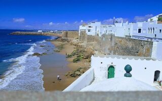
Asilah is a great spot for a visit and a destination run! Enjoy a 6 km 'runseeing' tour featuring a waterfront promenade, park, and a section along the 15-century rampart and through the historic Medina.
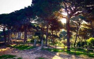
Great spot for running just west of Tangier. Wooded park featuring several km of trails through a Mediterranean landscape on a combination of wide dirt paths and some more rugged options. There are some great sea views.
Run at this spot that's the northwestern point in Africa, overlooking the Strait of Gibraltar where the Atlantic & Mediterranean meet. Very scenic and very hilly! Good network of low-trafficked roads, gravel paths, and some more rugged trails.
Get up early to run the narrow streets and alleys of the Ancien Medina. We've mapped an outline route around Tangier's historic highlights: Medina, ancient gates, Bab Bhar Stairs, Mendoubia Garden, Merkala Garden, Marshan Park, & more.
Share your feedback on this route and see that of other Great Runs users. Click on the image icon to upload a photo. And please let us know if there are notes or changes we should incorporate!
Subscribe
0 Comments
Oldest
Newest
Inline Feedbacks
View all comments
Essentials
Up to 8.5 km (5.3 miles) one-way. The 3 km along Ave. de la Plage Merkala is the best section
108m (356 feet)
Any point along route. Dar Al-Baroud Tower is a central access point. East end is Villa Harris Park.

Review or Comment on This Route/Share a Photo!
Share your feedback on this route and see that of other Great Runs users. Click on the image icon to upload a photo. And please let us know if there are notes or changes we should incorporate!