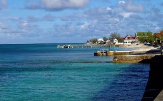
Grace Bay Beach: The sprawling white sands of Grace Bay offer up miles upon miles of flat beach running along the north coast of Providenciales. Since this is a popular resort area, many visitors might find this beach right outside their hotel room. If not, the public can access the beach on the west end from either Grace Bay Public Beach or Princess Alexandra National Park. From here, runners can head east almost all the way to Smith’s Reef for a total of 8 km one-way. MAP.
Grace Bay Road: Road runners have no fear: if you prefer pavement to the beach, there is an option for you in Grace Bay. The Grace Bay Road, which stretches about 5 km from the Ailla Canal in the Leeward Settlement to Princess Drive in Kingston, has a nice sidewalk. It’s also a nice tour of the various resorts, restaurants, and shops of Grace Bay. On the south end, it’s possible to continue on Lower Bight Road for some extra distance. Some runners choose to loop back on the Leeward Highway, but note that this busier street has no sidewalk. MAP.
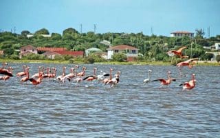
Venetian Road: For those who prefer a residential run close to the action of the developed side of Provo, the Venetian Road Settlement is a great choice. This street, stemming off Leeward Highway near the Bight Settlement, runs for several kilometers past beautiful rental villas and the scenic Turtle and Flamingo lakes. Runners can add on side streets, or follow the road all the way out to “Turtle Tail” for distances of up to 7.5 km one way. MAP.
West End
The quiet west side of Provo enjoys a nice break from the traffic and resort hustle and bustle of Grace Bay. If runners can slip away to this side of the island, the dirt roads and trails here are a real treat. Here are a couple of suggestions:
Malcolm Road: Starting from the Millennium Highway on the east side of Wheeland Settlement, this dirt road travels west all the way to Malcolm’s Road Beach. It’s about 5 km one-way. Runners can also tack on the residential side streets along the beach for more distance. MAP.
West Harbour Bluff: A fabulous 10 km stretch of road to some of the most scenic spots on Providenciales, the West Harbour Bluff Road begins as Tom Lightbourne Road, just off the Millenium Highway about 5 km from town. The road is paved for the first 1.6 km or so, then turns to dirt, covering a beautiful stretch of the island before arriving at the bluff. Here, runners can enjoy ocean views, a beach, and rock inscriptions left behind by shipwrecked sailors. MAP.
Grace Bay Beach: The sprawling white sands of Grace Bay offer up miles upon miles of flat beach running along the north coast of Providenciales. Since this is a popular resort area, many visitors might find this beach right outside their hotel room. If not, the public can access the beach on the west end from either Grace Bay Public Beach or Princess Alexandra National Park. From here, runners can head east almost all the way to Smith’s Reef for a total of 8 km one-way. MAP.
Grace Bay Road: Road runners have no fear: if you prefer pavement to the beach, there is an option for you in Grace Bay. The Grace Bay Road, which stretches about 5 km from the Ailla Canal in the Leeward Settlement to Princess Drive in Kingston, has a nice sidewalk. It’s also a nice tour of the various resorts, restaurants, and shops of Grace Bay. On the south end, it’s possible to continue on Lower Bight Road for some extra distance. Some runners choose to loop back on the Leeward Highway, but note that this busier street has no sidewalk. MAP.
Venetian Road: For those who prefer a residential run close to the action of the developed side of Provo, the Venetian Road Settlement is a great choice. This street, stemming off Leeward Highway near the Bight Settlement, runs for several kilometers past beautiful rental villas and the scenic Turtle and Flamingo lakes. Runners can add on side streets, or follow the road all the way out to “Turtle Tail” for distances of up to 7.5 km one way. MAP.
West End
The quiet west side of Provo enjoys a nice break from the traffic and resort hustle and bustle of Grace Bay. If runners can slip away to this side of the island, the dirt roads and trails here are a real treat. Here are a couple of suggestions:
Malcolm Road: Starting from the Millennium Highway on the east side of Wheeland Settlement, this dirt road travels west all the way to Malcolm’s Road Beach. It’s about 5 km one-way. Runners can also tack on the residential side streets along the beach for more distance. MAP.
West Harbour Bluff: A fabulous 10 km stretch of road to some of the most scenic spots on Providenciales, the West Harbour Bluff Road begins as Tom Lightbourne Road, just off the Millenium Highway about 5 km from town. The road is paved for the first 1.6 km or so, then turns to dirt, covering a beautiful stretch of the island before arriving at the bluff. Here, runners can enjoy ocean views, a beach, and rock inscriptions left behind by shipwrecked sailors. MAP.

Review or Comment on This Route/Share a Photo!
Share your feedback on this route and see that of other Great Runs users. Click on the image icon to upload a photo. And please let us know if there are notes or changes we should incorporate!