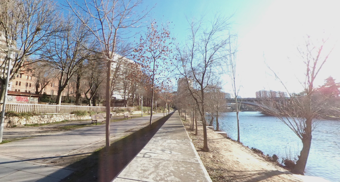
One of the best places to run in Valladolid is on the paths along the Pisuerga River (Río). It’s not one continuous dedicated river path, but rather a linear park type route, with a couple of short sections of roadside sidewalk. It’s possible to run for about 5 km, from the fabulous Museum Pedestrian Bridge (Pasarela Peatonal Del Museo de La Ciencia) north to the Soto de la Medinilla park at the VA-20 highway. It’s a mainly green space, with some nice views of the fairly narrow river.
Parque Ribera De Castilla. Creative Commons.
The south end is at Pasarela Peatonal Del Museo de La Ciencia. It’s a beautiful pedestrian bridge that leads to the Science Museum and concert hall on the west bank of the river. Head north along the Ruta verde Río Pisuerga, a linear park path. At 1.6 km, just past the Puente Isabel la Católica, you’ll reach the Parque de las Moreras. It’s a nice green space in the area of the Historic Center (Casco Viejo), with the Plaza Mayor as its anchor. The park features a rose garden, a riverside beach, and additional paths. Continue north, soon reaching the Parque Ribera De Castilla, another park with riverside and additional paths. You’ll then cross a small bridge over a canal just past the Puente de Sta Teresa into the Soto de la Medinilla park and the end of the path.
Add-Ons: Additional paths in the parks. Also at the south end, run over the Museum Bridge and connect to our Parque de los Almendros route. At the north end, there are some paths along the canal headed toward the University.
Scroll Down For Route Maps
Essentials
Up to 5.2 km (3.2 miles) one-way
101 feet (31 m) one-way, headed north
South end: Museum Bridge. Can also start at the Parque de las Moreras near the historic center and head north or south
Bus access. There are parking lots in the parks and the Science Museum
A 'Runseeing' tour of Valladolid, featuring the key sites of the historic center, including the Parque Campo Grande. It's just over 5 km, with good add-on opportunities.
A pleasant run in Valladolid exploring two parks: Alamendros Park and the nearby Contiendas Park. They're hilly parks with wide paths, open terrain, and nice viewpoints.
Pleasant gravel paths on both sides of the Canal de Castilla, with the option to take an adjacent path through the Jardín Botánico. An easy, flat, ~7 km loop!
Share your feedback on this route and see that of other Great Runs users. Click on the image icon to upload a photo. And please let us know if there are notes or changes we should incorporate!
Subscribe
0 Comments
Oldest
Newest
Inline Feedbacks
View all comments
Essentials
Up to 5.2 km (3.2 miles) one-way
101 feet (31 m) one-way, headed north
South end: Museum Bridge. Can also start at the Parque de las Moreras near the historic center and head north or south
Bus access. There are parking lots in the parks and the Science Museum


Review or Comment on This Route/Share a Photo!
Share your feedback on this route and see that of other Great Runs users. Click on the image icon to upload a photo. And please let us know if there are notes or changes we should incorporate!