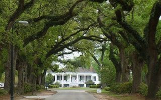
“Old Mobile,” which today is known as Downtown (Central Business District) and Midtown, is the historic heart of the city. On the main veins through this part of town, runners can enjoy a tour of some of Mobile’s iconic architecture from shady tree-lined sidewalks. Government Street, Dauphin Street, and Old Shell Road cut through most of the historic neighborhoods of Church Street, Oakleigh Garden, Leinkauf, Old Dauphin Way, and Lower Dauphin (LODA). We’ve mapped a route up and down these streets which results in a 4.7 mile loop, but runners can use the City of Mobile’s Historic Districts map to put together a DIY run.

Features:
Categories:
Scroll Down For Route Maps
Essentials
- 4.7 mile loop. Options to create your own route through the historic districts
- 55 feet
- Central Business District
- Government Street
Current Weather & Forecast

Mobile, US
4:52 am,
Jun 5, 2026
L: 18°
H: 20°
Daily ForecastHourly Forecast
Today
4:00 pm
18° / 20°°C
0 mm
0%
4 mph
84 %
1015 mb
0 mm/h
Tomorrow
4:00 pm
17° / 23°°C
1 mm
100%
6 mph
92 %
1018 mb
0 mm/h
Sunday
4:00 pm
16° / 24°°C
0.54 mm
54%
9 mph
97 %
1016 mb
0 mm/h
Monday
4:00 pm
15° / 20°°C
1 mm
100%
5 mph
99 %
1006 mb
0 mm/h
Tuesday
4:00 pm
10° / 19°°C
0.47 mm
47%
9 mph
94 %
1011 mb
0 mm/h
Today
7:00 am
16° / 20°°C
0 mm
0%
4 mph
70 %
1009 mb
0 mm/h
Today
10:00 am
16° / 18°°C
0 mm
0%
4 mph
78 %
1011 mb
0 mm/h
Today
1:00 pm
15° / 15°°C
0 mm
0%
4 mph
84 %
1013 mb
0 mm/h
Today
4:00 pm
15° / 15°°C
0 mm
0%
4 mph
83 %
1015 mb
0 mm/h
Today
7:00 pm
19° / 19°°C
0 mm
0%
4 mph
70 %
1016 mb
0 mm/h
Today
10:00 pm
23° / 23°°C
0.04 mm
4%
3 mph
61 %
1015 mb
0 mm/h
Tomorrow
1:00 am
23° / 23°°C
0.38 mm
38%
6 mph
67 %
1014 mb
0 mm/h
Other Routes in Mobile, AL
Run through this scenic tunnel of trees on the Spring Hill College campus then continue through the College Park neighborhood. Especially beautiful in spring.

Substantial park located 7 miles west of downtown is a wonderful green space for running. Perimeter loop is 2.4 miles, and there are many interior roads and paths, and a couple of lakes. Also the location of several Mobile cultural institutions.

A well-maintained trail system on the grounds of the University of South Alabama includes a beloved 5 km loop.
This large park in Claremont has its own ~2 mile paved walking/jogging path. There are nearby bike paths to add for more distance.
Loved for its diverse ecology and Civil War history, Blakeley State Park has over 16 miles of trails, including a paved ~9 mile bike path loop.

Search for alligators in the creek below this cool boardwalk section of the Eastern Shore Trail. It's a quick 2.5 mile (4 km) out and back. It's part of the longer Eastern Shore Trail, parts of which are nice for running.
Bordering the edge of the downtown airport, the 1.8 mile Airport Perimeter Trail runs from Doyle Park to Bayfront Road. Can be extended to Alligator Bayou via the Crepe Myrtle Trail, which follows Bayfront Rd. for 5.6 miles. Nice water views!

Two routes just south of Mobile: The Montrose Historic District has lovely homes and beautiful trees. And in Fairhope, the nearly 5 miles on Scenic Hwy 98 features beach-side parks along Mobile Bay, gracious homes, and live oaks.
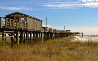
Take a day trip to Dauphin Island to run pristine white sand beaches or the paved bike path along Bienville Boulevard. Long, flat, and beach-y with classic water, sand, and beach shack views. 30 miles south of Mobile.
User Ratings
Leave A Review or Comment
Review or Comment on This Route/Share a Photo!
Share your feedback on this route and see that of other Great Runs users. Click on the image icon to upload a photo. And please let us know if there are notes or changes we should incorporate!