Cape Breton Island is a large island in northern Nova Scotia, known for the scenic Cabot Trail coastal drive. This rugged island is very hilly, so runners will have to find their spots. Unfortunately, we can’t recommend most of the Cabot Trail road (NS-30) for running, as it’s generally VERY hilly and also has very little shoulder. In summer, there are quite a number of cars and RVs. We have researched a few scenic, runnable spots on Cape Breton (see our separate post for Sydney running options):
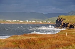
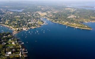
Ingonish Area: This area is flatter and there are some nice running options off the main road. At Ingonish Beach, there’s a nice 4 km loop from the Ingonish Visitor Center to Ingonish Beach Rd. Note there’s a trail between Park Headquaters Ln. and the lake that’s not on maps but very runnable. ROUTE MAP.
The Middle Head Trail is an easier, runnable trail that’s ~2 km one-way, starting near the famous Cape Breton Highlands Links.
Chéticamp Island. Wikimedia Commons
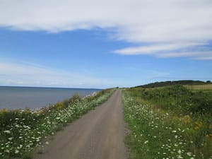
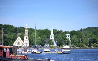
ChéticampArea. This fishing village on the western side of Cape Breton is also a flatter area with some decent running off the main road. There are 3-4 km along the main road, NS-30, on a sidewalk/path with some nice water views, including the scenic De Lances des Boise Marine at the northern end. Another great option is Chéticamp Island. One can run on the shoreline along Du Phare Rd. for up to 8 km one-way, with beautiful water views and lovely open terrain. Use this ROUTE MAP to design a route of preferred length!
Trail in Creignish. Flickr.
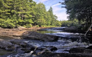
The Celtic Shores Coastal Trail. A 92 km (57 mi) multi-use trail, along former rail bed, stretching from Port Hastings to Inverness on the west coast of Cape Breton Island. An easy, flat trail that’s a great option for an off-road distance run. The terrain includes some coastline and harbor sections, woods, and some more remote areas. The surface is smooth and hard-packed. There are numerous access points. The park website shows the trail divided into five sections, with numerous downloadable maps. The more coastal sections are the 30 km between Canso Canal (Port Hastings) and Judique. WEBSITEOVERVIEW MAP
Cape Breton Island is a large island in northern Nova Scotia, known for the scenic Cabot Trail coastal drive. This rugged island is very hilly, so runners will have to find their spots. Unfortunately, we can’t recommend most of the Cabot Trail road (NS-30) for running, as it’s generally VERY hilly and also has very little shoulder. In summer, there are quite a number of cars and RVs. We have researched a few scenic, runnable spots on Cape Breton (see our separate post for Sydney running options):
Ingonish Area: This area is flatter and there are some nice running options off the main road. At Ingonish Beach, there’s a nice 4 km loop from the Ingonish Visitor Center to Ingonish Beach Rd. Note there’s a trail between Park Headquaters Ln. and the lake that’s not on maps but very runnable. ROUTE MAP.
The Middle Head Trail is an easier, runnable trail that’s ~2 km one-way, starting near the famous Cape Breton Highlands Links.
Chéticamp Island. Wikimedia Commons
ChéticampArea. This fishing village on the western side of Cape Breton is also a flatter area with some decent running off the main road. There are 3-4 km along the main road, NS-30, on a sidewalk/path with some nice water views, including the scenic De Lances des Boise Marine at the northern end. Another great option is Chéticamp Island. One can run on the shoreline along Du Phare Rd. for up to 8 km one-way, with beautiful water views and lovely open terrain. Use this ROUTE MAP to design a route of preferred length!
Trail in Creignish. Flickr.
The Celtic Shores Coastal Trail. A 92 km (57 mi) multi-use trail, along former rail bed, stretching from Port Hastings to Inverness on the west coast of Cape Breton Island. An easy, flat trail that’s a great option for an off-road distance run. The terrain includes some coastline and harbor sections, woods, and some more remote areas. The surface is smooth and hard-packed. There are numerous access points. The park website shows the trail divided into five sections, with numerous downloadable maps. The more coastal sections are the 30 km between Canso Canal (Port Hastings) and Judique. WEBSITEOVERVIEW MAP
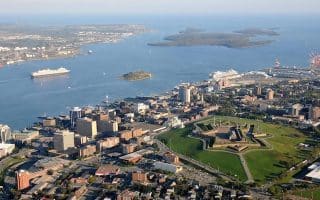
Click here for our separate guide to running in the Halifax-Dartmouth area: several waterfront routes, Point Pleasant Park, a 'runseeing' tour up to the Citadel, Chain of Lakes Trail, Shubie Park, and pleasant residential neighborhoods.
Lovely running on the Chester Peninsula. Enjoy several waterfront roads up and down coves, with views of harbours, nice homes, and yachts. For off-road running, enjoy a section of the 35 km Chester Connection trail.
A wonderful 10k coastal run on quiet roads, with Nice views of Mahone Harbour. For variety or an add-on, the Bay to Bay Trail runs for 13.7 km between Mahone Bay and Lunenburg.
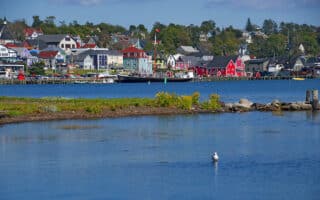
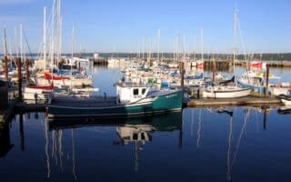
Extensive waterfront running opportunities in this popular coastal town. Run along Back Harbour using First Peninsula Rd. Or, just north of Lunenburg, run along Second Peninsula Rd. as far as Bachman's Beach and then north to Sunnybrook!
Huge national park in the center of the province. There are trails for runners of all abilities, including several multi-use trails of moderate length. The park is also popular for canoeing, camping, hiking, and swimming.
The best running spots in this central Nova Scotia town are the many km of trails in the 3,000-acre Victoria Park. Test your lungs on 175-step Jacob's Ladder! It's also fun to explore the paths around the Dalhousie Agricultural University campus.
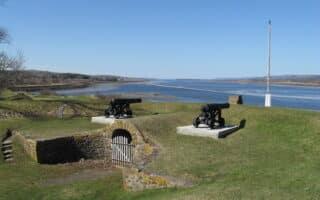
One of our favorite Nova Scotia runs. Enjoy an attractive, historic town, waterfront, dyke road, a multi-use path through vineyards and orchards, and the landscaped grounds of a UNESCO World Heritage site --- all in one run!
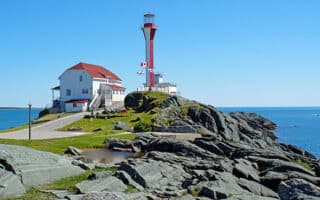
Wonderful 8 km 'runseeing' tour of this lovely waterfront community includes the shoreline, loop around the Fort, Botanical Gardens. and lake trail. For a longer or separate run, the Annapolis County Rail Trail goes for many km north or south.
Pleasant run along the Annapolis Basin shoreline toward the Digby Cut, which is the entrance to the Bay of Fundy. Water views for most of the route. For a long off-road option, the Digby County Rail trail runs north to Bear River or inland.
The best running options in this port town in southwestern Nova Scotia are 4 km along the water, the extensive Yarmouth County Rail Trail that heads north or south of town, and paths around the Cape Forchu Lighthouse.
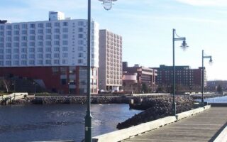
Two good Sydney routes: A 'downtown tour' incorporating the waterfront boardwalk and some nice parks; and a waterfront run on the west side of Sydney Harbour, with an optional loop around Petersfield Provincial Park and the Coast Guard College.
Share your feedback on this route and see that of other Great Runs users. Click on the image icon to upload a photo. And please let us know if there are notes or changes we should incorporate!


Review or Comment on This Route/Share a Photo!
Share your feedback on this route and see that of other Great Runs users. Click on the image icon to upload a photo. And please let us know if there are notes or changes we should incorporate!