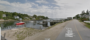
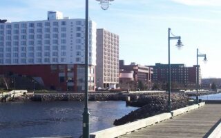
There’s very pleasant waterfront running on the Chester Peninsula. Chester is a popular cruising destination located less than an hour’s drive from Halifax. We’ve mapped a route of up to 14 km, on roads traveling up and down several coves and inlets — choose how much you want to do! There’s also the Chester Connection Trail for a long off-road run.
Google Street View
Waterfront Route: Start in the center of the pretty town of Chester, enjoying some of the pretty residential and commercial streets. Then run along Nauss Point Rd. on the eastern side of Front Harbour, and then the western side, continuing south along the Chester waterfront. Take a 1 km out and back jaunt down Peninsula Rd. Ext., enjoying the water and yacht views. The next section uses Victoria St. to run off the Chester peninsula, running on Walker Rd. along Mill Cove. Then, use the Chester Connection trail briefly to access the waterfront roads along the eastern and western sides of Marriotts Cove — this section is ~6 km. Use the multi-use path to return to Chester. Shorter Option: the 6 km Marriotts Cove section can be eliminated
Chester Connection Trail: This 35 km section of a nearly seamless Rum Runners gravel multi-use path on Nova Scotia’s south shore travels between East River and Martin’s River. TRAIL MAP
Click here for our separate guide to running in the Halifax-Dartmouth area: several waterfront routes, Point Pleasant Park, a 'runseeing' tour up to the Citadel, Chain of Lakes Trail, Shubie Park, and pleasant residential neighborhoods.
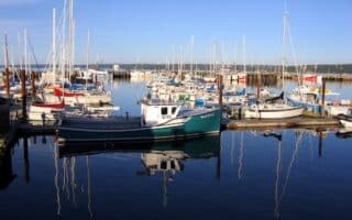
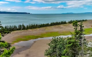
A wonderful 10k coastal run on quiet roads, with Nice views of Mahone Harbour. For variety or an add-on, the Bay to Bay Trail runs for 13.7 km between Mahone Bay and Lunenburg.
Extensive waterfront running opportunities in this popular coastal town. Run along Back Harbour using First Peninsula Rd. Or, just north of Lunenburg, run along Second Peninsula Rd. as far as Bachman's Beach and then north to Sunnybrook!
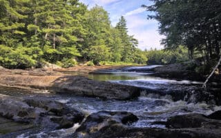
Huge national park in the center of the province. There are trails for runners of all abilities, including several multi-use trails of moderate length. The park is also popular for canoeing, camping, hiking, and swimming.
The best running spots in this central Nova Scotia town are the many km of trails in the 3,000-acre Victoria Park. Test your lungs on 175-step Jacob's Ladder! It's also fun to explore the paths around the Dalhousie Agricultural University campus.
One of our favorite Nova Scotia runs. Enjoy an attractive, historic town, waterfront, dyke road, a multi-use path through vineyards and orchards, and the landscaped grounds of a UNESCO World Heritage site --- all in one run!
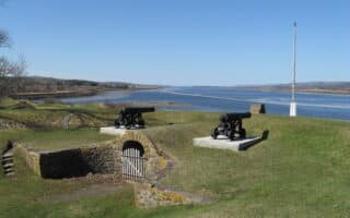
Wonderful 8 km 'runseeing' tour of this lovely waterfront community includes the shoreline, loop around the Fort, Botanical Gardens. and lake trail. For a longer or separate run, the Annapolis County Rail Trail goes for many km north or south.
Pleasant run along the Annapolis Basin shoreline toward the Digby Cut, which is the entrance to the Bay of Fundy. Water views for most of the route. For a long off-road option, the Digby County Rail trail runs north to Bear River or inland.
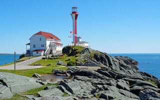
The best running options in this port town in southwestern Nova Scotia are 4 km along the water, the extensive Yarmouth County Rail Trail that heads north or south of town, and paths around the Cape Forchu Lighthouse.
Two good Sydney routes: A 'downtown tour' incorporating the waterfront boardwalk and some nice parks; and a waterfront run on the west side of Sydney Harbour, with an optional loop around Petersfield Provincial Park and the Coast Guard College.
The most scenic sections of the Cabot Trail coastal drive aren't suitable for running. But there are some running options at Ingonish Beach. On the west coast, good running in Chéticamp and the Celtic Shores Coastal Trail.
Share your feedback on this route and see that of other Great Runs users. Click on the image icon to upload a photo. And please let us know if there are notes or changes we should incorporate!


Review or Comment on This Route/Share a Photo!
Share your feedback on this route and see that of other Great Runs users. Click on the image icon to upload a photo. And please let us know if there are notes or changes we should incorporate!