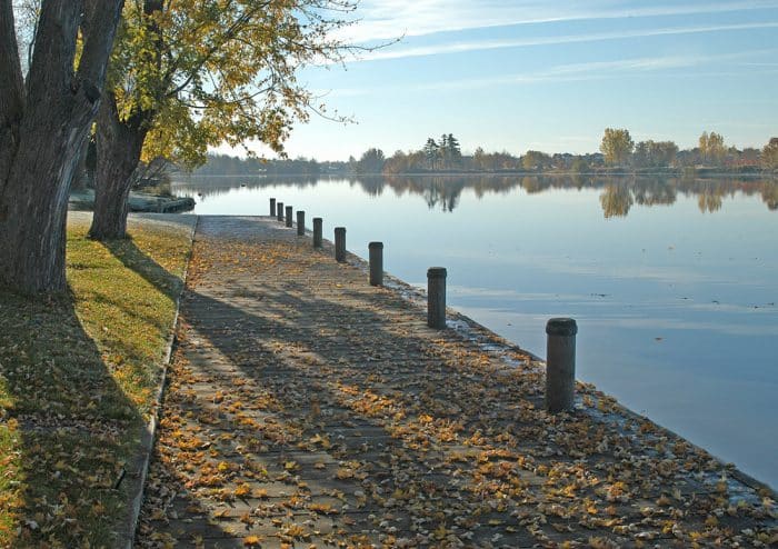
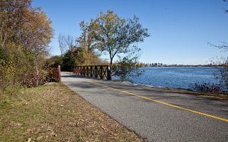
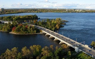
The Rideau River Eastern Pathway is another pleasant, paved pathway, following the Rideau River for up to 7.3 miles (11.7 km) from Rideau Falls to the confluence with the Rideau Canal at Hogs Back Falls. There are water views and parks along the way, as well as numerous bridge and pedestrian crossings. One nice option, at the 3.3 mile mark, is to take the Hurdman Bridge crossing to the western side of the river, and a 1-mile Rideau River Nature trail.
Add-Ons: See our Experimental Pathway Route for a nice add-on.
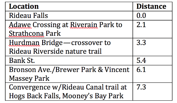
Distances, in Miles
The Rideau River Eastern Pathway is another pleasant, paved pathway, following the Rideau River for up to 7.3 miles (11.7 km) from Rideau Falls to the confluence with the Rideau Canal at Hogs Back Falls. There are water views and parks along the way, as well as numerous bridge and pedestrian crossings. One nice option, at the 3.3 mile mark, is to take the Hurdman Bridge crossing to the western side of the river, and a 1-mile Rideau River Nature trail.
Add-Ons: See our Experimental Pathway Route for a nice add-on.
Distances, in Miles
Scroll Down For Route Maps
Essentials
Up to 11.7 km (7.3 miles) one-way, flat and mostly paved.
A 5-mile tour of Ottawa’s most important sites: Parliament Hill, the Royal Canadian Mint, National Gallery, Notre Dame Cathedral, National War Memorial, Supreme Court, and the Library and Archives. Can combine with iconic Rideau Canal & Rideau River routes.
A really nice run in the southern part of Ottawa, showcasing Canada's largest arboretum and a paved path through the Experimental Farm. Grain-filled fields, spectacular gardens, and beautiful trees.
Pleasant multi-use path along the Ottawa River extending east from Rockcliffe Park for up to 13.5 km. Add on with your own route through the bucolic Rockliffe Park neighborhood.
Run on a multi-use path headed west along the Ottawa River. Great views and variety, skirting the two provinces. Use the Champlain Bridge to run between the Quebec and Ontario sides.
Gatineau Park is a great destination if you have time. There are several lakeside beaches, and more than 100 miles of paved and unpaved trails for walking and running. Particularly beautiful in autumn!
Located 15 km south of Ottawa between Nepean and Kanata, Stony Swamp is a network of beaver ponds, wetlands and forests, with 40 km of trails. A mix of nature trails, cycling trails, and trails that are easy-to-moderate trail running.
Share your feedback on this route and see that of other Great Runs users. Click on the image icon to upload a photo. And please let us know if there are notes or changes we should incorporate!
Subscribe
0 Comments
Oldest
Newest
Inline Feedbacks
View all comments
Essentials
Up to 11.7 km (7.3 miles) one-way, flat and mostly paved.


Review or Comment on This Route/Share a Photo!
Share your feedback on this route and see that of other Great Runs users. Click on the image icon to upload a photo. And please let us know if there are notes or changes we should incorporate!