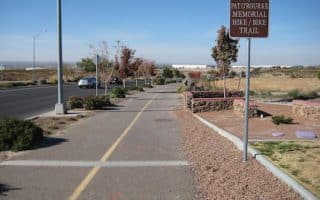
Las Cruces, being on the edge of the Chihuahuan Desert and surrounded by the Organ Mountains, features tremendous trail running opportunities. There are some easier dirt roads and desert trails, but mainly this is moderate to challenging trail running. Also note, these trails are all open & exposed. Use caution in the sun and heat! These are some of the recommended trail running options near Las Cruces:
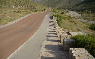
Sierra Vista Trail. A 29-mile National Recreation Trail administered by the BLM and popular with mountain bikers. The trail runs along the desert floor along the western flank of the Organ Mountains and the eastern side of the Franklin Mountains. The section of trail closest to Las Cruces starts off Dipping Springs Rd. and is the easiest section. Further south, the trail can be sandy or rocky and more rugged. INFORMATION & TRAIL MAP
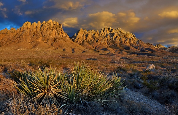
Organ Mountains Desert Peaks National Monument. There is spectacular trail running in the Organ Mountains, rock pinnacles rising to 9,000 feet and located just east of Las Cruces. The National Monument, administered by the BLM, is a huge 500,000 acres and includes 48 miles of hiking trails and 54 miles of bicycle trails. This is generally moderate to challenging trail running. Some easier trail running is on the bicycle trails in the Dona Ana Mountains. We suggest going to the Visitor Center to get a detailed trail brochure and inquire about trail running that suits your abilities. INFORMATION & TRAIL MAP
Picacho Peak Recreation Area. There are 15 miles of trails in the area of this scenic mountain, popular for hiking & mountain biking. For a real challenge, there’ the 1.5 mile trail to the summit of Picacho Peak.
Dripping Springs Natural Area. A few miles east of Las Cruces. At the base of some scenic mountains, there are four miles of easy trails featuring desert scrub and low elevation pinon-juniper and oak woodlands. Nice views of surrounding mountains.
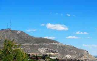
Franklin Mountains State Park. Closer to El Paso and a great trail running destination. This 24,000-acre state park features 100+ miles of trails, with something for all abilities. The easiest trails for running are off Tom Mays Rd. We recommend the Tom Mays Trail and the ~5 mile Upper Sunset/Lower Sunset loop. The best trail run rated ‘moderate’ is the 3-mile Cardiac Road – The Maze Loop. TRAIL MAP
Las Cruces, being on the edge of the Chihuahuan Desert and surrounded by the Organ Mountains, features tremendous trail running opportunities. There are some easier dirt roads and desert trails, but mainly this is moderate to challenging trail running. Also note, these trails are all open & exposed. Use caution in the sun and heat! These are some of the recommended trail running options near Las Cruces:
Sierra Vista Trail. A 29-mile National Recreation Trail administered by the BLM and popular with mountain bikers. The trail runs along the desert floor along the western flank of the Organ Mountains and the eastern side of the Franklin Mountains. The section of trail closest to Las Cruces starts off Dipping Springs Rd. and is the easiest section. Further south, the trail can be sandy or rocky and more rugged. INFORMATION & TRAIL MAP
Organ Mountains Desert Peaks National Monument. There is spectacular trail running in the Organ Mountains, rock pinnacles rising to 9,000 feet and located just east of Las Cruces. The National Monument, administered by the BLM, is a huge 500,000 acres and includes 48 miles of hiking trails and 54 miles of bicycle trails. This is generally moderate to challenging trail running. Some easier trail running is on the bicycle trails in the Dona Ana Mountains. We suggest going to the Visitor Center to get a detailed trail brochure and inquire about trail running that suits your abilities. INFORMATION & TRAIL MAP
Picacho Peak Recreation Area. There are 15 miles of trails in the area of this scenic mountain, popular for hiking & mountain biking. For a real challenge, there’ the 1.5 mile trail to the summit of Picacho Peak.
Dripping Springs Natural Area. A few miles east of Las Cruces. At the base of some scenic mountains, there are four miles of easy trails featuring desert scrub and low elevation pinon-juniper and oak woodlands. Nice views of surrounding mountains.
Franklin Mountains State Park. Closer to El Paso and a great trail running destination. This 24,000-acre state park features 100+ miles of trails, with something for all abilities. The easiest trails for running are off Tom Mays Rd. We recommend the Tom Mays Trail and the ~5 mile Upper Sunset/Lower Sunset loop. The best trail run rated ‘moderate’ is the 3-mile Cardiac Road – The Maze Loop. TRAIL MAP


Review or Comment on This Route/Share a Photo!
Share your feedback on this route and see that of other Great Runs users. Click on the image icon to upload a photo. And please let us know if there are notes or changes we should incorporate!