Bellingham has some terrific running along the waterfront. We’ve combined two waterfront paths that can be run standalone or combined for a 10.6 mile spectacular!
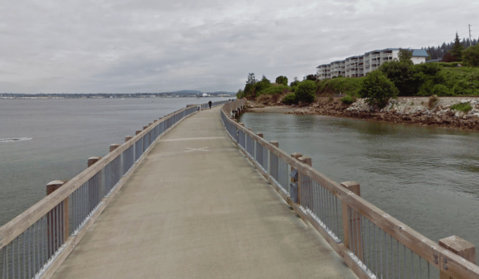
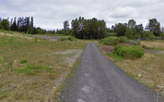
The first section of the route is the The South Bay Trail — the signature waterfront run in Bellingham. The paved multi-use path follows Bellingham Bay for 2 miles from the central business district in Bellingham south to the Grace Statue on Taylor Dock. There are great views of the water, Lummi Island, and the Chuckanut Mountains. A particularly scenic section is the 1/2 mile Bellingham/Taylor Dock Boardwalk that juts into the bay. Start downtown at the waterside Maritime Heritage Park, or at the trailhead off Railroad Ave, 0.6 miles from the park.
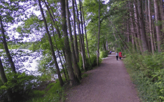
Zuanich Point Park. Google Street View
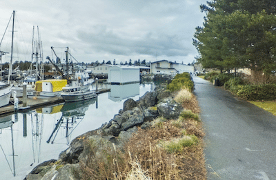
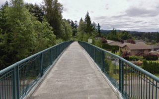
The other waterfront goes around Squalicum Harbor, out to Zuanich Point. To access the path, run through Maritime Heritage Park. and then along Roeder Ave. (a bit industrial) for 0.5 miles. Join the paved waterfront path, which follows the water for 1.6 miles around the beautiful Hotel Bellwether, Squalicum Harbor, to Zuanich Point Park. Great water views and lots of gorgeous boats!
Add-Ons. In Bellingham, our Western Washington University/Arboretum route is 1/2 mile inland. At the Fairhaven end, add with the Lower Padden Creek and Larrabee Trail or some of the residential streets in Fairhaven and Edgemoor.
Bellingham has some terrific running along the waterfront. We’ve combined two waterfront paths that can be run standalone or combined for a 10.6 mile spectacular!
The first section of the route is the The South Bay Trail — the signature waterfront run in Bellingham. The paved multi-use path follows Bellingham Bay for 2 miles from the central business district in Bellingham south to the Grace Statue on Taylor Dock. There are great views of the water, Lummi Island, and the Chuckanut Mountains. A particularly scenic section is the 1/2 mile Bellingham/Taylor Dock Boardwalk that juts into the bay. Start downtown at the waterside Maritime Heritage Park, or at the trailhead off Railroad Ave, 0.6 miles from the park.
Zuanich Point Park. Google Street View
The other waterfront goes around Squalicum Harbor, out to Zuanich Point. To access the path, run through Maritime Heritage Park. and then along Roeder Ave. (a bit industrial) for 0.5 miles. Join the paved waterfront path, which follows the water for 1.6 miles around the beautiful Hotel Bellwether, Squalicum Harbor, to Zuanich Point Park. Great water views and lots of gorgeous boats!
Add-Ons. In Bellingham, our Western Washington University/Arboretum route is 1/2 mile inland. At the Fairhaven end, add with the Lower Padden Creek and Larrabee Trail or some of the residential streets in Fairhaven and Edgemoor.
Scroll Down For Route Maps
Essentials
Combined route is 10.6 miles; South Bay Trail is 4 miles out and back; Zuanich trail 3.2 miles out and bacl
391 feet (119m) for combined route
Maritime Heritage Park is a good central starting point; Or at trailheads
Combine the gravel Lower Padden Creek and Larrabee Trail/Interurban Trail for a gradual, hilly run from Fairhaven to Chuckanut Mountain overlooking Teddy Bear Cove. Trail passes through a residential area, Fairhaven Park, and a more forested section.
Just 1/2 mile from downtown, there's a lovely ~3 mile, hilly run combining the attractive pedestrian paths, fields, & running track of Western Washington University with the forested paths of the Sehome Arboretum.
A pleasant 10 run showcasing several small parks in central Bellingham: Squalicum Creek Park, Cornwall Park, Broadway Park, and the nice residential streets of the Columbia neighborhood.
A wide, gravel path runs for 3.6 miles between Memorial Park to Lake Whatcom. Mainly wooded, with some great views of the lake from a pedestrian bridge off Alabama St. Can add with a few miles of trails in Whatcom Falls Park.
A popular spot just 5 miles south of downtown Bellingham. A wide, gravel path circles Lake Padden for 2.6 miles. Do some laps! Adjacent to the lake are the Galbraith Mountain and Padden Trails, which offer hilly, more rugged trail running.
A scenic, moderate trail run through 350 acres of old growth forest. The preserve is 5 miles east of downtown. The route is up to 4.9 miles, including the 3-mile Main Loop and 1.8 mile loop around Lake Geneva.
Share your feedback on this route and see that of other Great Runs users. Click on the image icon to upload a photo. And please let us know if there are notes or changes we should incorporate!
Subscribe
0 Comments
Oldest
Newest
Inline Feedbacks
View all comments
Essentials
Combined route is 10.6 miles; South Bay Trail is 4 miles out and back; Zuanich trail 3.2 miles out and bacl
391 feet (119m) for combined route
Maritime Heritage Park is a good central starting point; Or at trailheads

Review or Comment on This Route/Share a Photo!
Share your feedback on this route and see that of other Great Runs users. Click on the image icon to upload a photo. And please let us know if there are notes or changes we should incorporate!