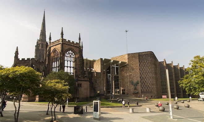
This 5k ‘Runseeing’ tour of Coventry’s central section explores some of the city’s key sites and historic highlights. It includes Cathedral Quarter, some small city parks, and the canal basin area. A longer option adds War Memorial Park.
Start in the Cathedral Quarter area. In this section, you sort of have to create your own route around the Coventry Cathedral (which incorporates the bombed out remains and a more modern building) and the medieval buildings of Priory Row and then along Bayley Lane. Then, use High St. (good pedestrian way) to City Centre/Coventry Cross, and run on the Broadgate path west to Coventry Fountain. Run north along Market Way/Smithord Way — a pedestrianized shopping street on the west side of the West Orchards Shopping Center.
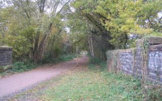
Glass Bridge/Lady Herbert’s Garden. CC: Jim Linwood
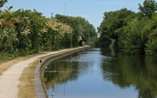
The next section is through two small city parks — use the Glass Bridge to connect to Lady Herbert’s Gardens, then use the path across the Ringway to Swanswell Park, which has some nice paths and a small pond. Finally, make your way over to the Coventry Canal (LEFT on Howard St., LEFT on Harnell Ln.), crossing the bridge to the east side and running on the footpath around the Canal Basin. Add-Ons: Coventry Canal path, headed north.
War Memorial Park
Longer Option: Run south to War Memorial Park. From High St., use the path along Hertford St./Warwick Row, then the sidewalk along busy Warwick St. to the park. It’s ~1 mile. But War Memorial Park is worth it! It’s among the most popular places to run in Coventry, with its mix of wide, tree-lined paths, and also some more rugged trails. A loop of the park is ~1.5 miles. War Memorial Park is also side of a parkrun.
This 5k ‘Runseeing’ tour of Coventry’s central section explores some of the city’s key sites and historic highlights. It includes Cathedral Quarter, some small city parks, and the canal basin area. A longer option adds War Memorial Park.
Start in the Cathedral Quarter area. In this section, you sort of have to create your own route around the Coventry Cathedral (which incorporates the bombed out remains and a more modern building) and the medieval buildings of Priory Row and then along Bayley Lane. Then, use High St. (good pedestrian way) to City Centre/Coventry Cross, and run on the Broadgate path west to Coventry Fountain. Run north along Market Way/Smithord Way — a pedestrianized shopping street on the west side of the West Orchards Shopping Center.
Glass Bridge/Lady Herbert’s Garden. CC: Jim Linwood
The next section is through two small city parks — use the Glass Bridge to connect to Lady Herbert’s Gardens, then use the path across the Ringway to Swanswell Park, which has some nice paths and a small pond. Finally, make your way over to the Coventry Canal (LEFT on Howard St., LEFT on Harnell Ln.), crossing the bridge to the east side and running on the footpath around the Canal Basin. Add-Ons: Coventry Canal path, headed north.
War Memorial Park
Longer Option: Run south to War Memorial Park. From High St., use the path along Hertford St./Warwick Row, then the sidewalk along busy Warwick St. to the park. It’s ~1 mile. But War Memorial Park is worth it! It’s among the most popular places to run in Coventry, with its mix of wide, tree-lined paths, and also some more rugged trails. A loop of the park is ~1.5 miles. War Memorial Park is also side of a parkrun.
Scroll Down For Route Maps
Essentials
3.25 miles (5.2 km). Longer Option to War Memorial Park adds ~3.5 miles
Former towpath is now a pleasant, easy to follow footpath along the Coventry Canal. It's 5.5 miles from the Canal Basin to Hawkesbury Junction. Canal views the whole way, and some pastoral, green sections.
In the northeast part of Coventry, there's a linear park of several green spaces, anchored by footpaths along the River Sowe. We've mapped two routes, which can be combined.
Coombe Abbey Country Park, located about 5 miles east of Coventry Center, is a lovely spot for a run. The 500-acre green space features a 5-6 mile network of paths through historic woodlands, gardens and lakes.
A few miles southwest of Coventry, the Kenilworth Greenway offers a nice opportunity for an easy, flat off-road run. The multi-use trail runs for 5 miles between Berkswell and Kenilworth. The landscape is fairly open and pastoral, passing by numerous fields & farms.
Share your feedback on this route and see that of other Great Runs users. Click on the image icon to upload a photo. And please let us know if there are notes or changes we should incorporate!
Subscribe
0 Comments
Oldest
Newest
Inline Feedbacks
View all comments
Essentials
3.25 miles (5.2 km). Longer Option to War Memorial Park adds ~3.5 miles


Review or Comment on This Route/Share a Photo!
Share your feedback on this route and see that of other Great Runs users. Click on the image icon to upload a photo. And please let us know if there are notes or changes we should incorporate!