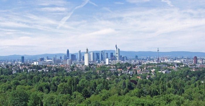
The 1200 acre Frankfurt City Forest (Frankfurter Stadtwald) forest is the largest inner-city forest in Germany. Dating back to the 13th century, the Forest covers the southern areas of Schwanheim, Niederrad, Sachsenhausen and Oberrad, as well the northern parts of the Stadtteil Flughafen district. Four nature trails and sport paths cross the Forest. There are 1600 seating benches, 25 rest huts, 6 playgrounds, and 9 ponds. The forest is 7 km south of the city. There’s a 400m running track at the northeastern end — look for Spiridon Frankfurt in Google Maps. The western section (Unterwald) is near Frankfurt Airport.
There are many running opportunities along the 450 km network of trails, including 157 km of signposted cycling and hiking tracks. It’s best to get a map from the Visitor Center — very little is available online!
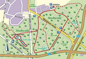
Runners World has a suggestion of the following route: Distance: 2 to 20 km. The circuit starts at the Oberschweinstiege, where there is also a car park. From there to Darmstädter Landstraße, over the pedestrian bridge, at a central intersection on the Hainer Weg northward. Via the Babenhauser Landstraße, to the Goetheturm, then on the Kesselbruchschneise as well as the Schillerschneise back. For other routes, best to get a map from the Visitor Center (very little is available online!).
The two main attractions are the Stadtwaldhaus / State Forest House Visitors Centre in the middle of the forest, and the GoetheTurm / Goethe Tower – a great lookout over the forest and Frankfurt.
The 1200 acre Frankfurt City Forest (Frankfurter Stadtwald) forest is the largest inner-city forest in Germany. Dating back to the 13th century, the Forest covers the southern areas of Schwanheim, Niederrad, Sachsenhausen and Oberrad, as well the northern parts of the Stadtteil Flughafen district. Four nature trails and sport paths cross the Forest. There are 1600 seating benches, 25 rest huts, 6 playgrounds, and 9 ponds. The forest is 7 km south of the city. There’s a 400m running track at the northeastern end — look for Spiridon Frankfurt in Google Maps. The western section (Unterwald) is near Frankfurt Airport.
There are many running opportunities along the 450 km network of trails, including 157 km of signposted cycling and hiking tracks. It’s best to get a map from the Visitor Center — very little is available online!
Runners World has a suggestion of the following route: Distance: 2 to 20 km. The circuit starts at the Oberschweinstiege, where there is also a car park. From there to Darmstädter Landstraße, over the pedestrian bridge, at a central intersection on the Hainer Weg northward. Via the Babenhauser Landstraße, to the Goetheturm, then on the Kesselbruchschneise as well as the Schillerschneise back. For other routes, best to get a map from the Visitor Center (very little is available online!).
The two main attractions are the Stadtwaldhaus / State Forest House Visitors Centre in the middle of the forest, and the GoetheTurm / Goethe Tower – a great lookout over the forest and Frankfurt.
Essentials
450 km of trails!! Suggest getting a map at the Visitor Center
This 'runseeing' tour of Frankfurt hits both the historic and scenic highlights of the main part of the city: Altstadt, Zeil shopping promenade, the linear park, Grüneburgpark botanical gardens, Eurotower, river path.
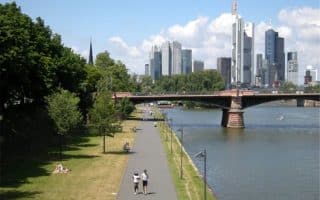
Among the signature runs in Frankfurt. Wonderful waterfront paths with great views. South side features the green belt along the Museum Embankment, while the north side skirts the Altstadt. Numerous bridges allow for loops of varying lengths.
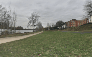
This route adds to our central Main River route, following a multi-use path on the south bank for up to 15 km east to Hanau. Quite pastoral, with river views, some wooded sections, parks, & Rumpenheimer Castle Park.
Three neighboring green spaces in the northwest part of Frankfurt. Enjoy the botanical gardens of Palmengarten, and then Grüneburgpark, whose paths are done in the English style. Also includes a quick jaunt through the campus of Goethe University.
A series of park lands around the former city walls, making for a nearly 5 km green belt. A great way to skirt the perimeter of old and new Frankfurt, through seven areas named after former city gates. Add on by running along the Main river paths.
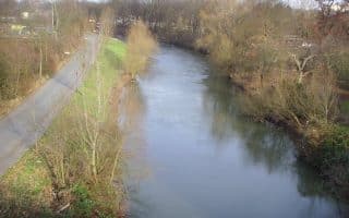
Pleasant, flat path along this tributary of the Main river. Runs 10.5 km from Höchst, north to Eschersheim. Nice views of the river, and increasingly country-like as you head north. Good public transport access at either end.
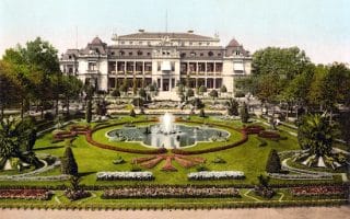
An enjoyable run in Hanau, located 25 km east of Frankfurt. Our 9.7 km loop features the scenic grounds of the Schloss Philippsruhe (castle) and paths along the Main River.
Share your feedback on this route and see that of other Great Runs users. Click on the image icon to upload a photo. And please let us know if there are notes or changes we should incorporate!
Subscribe
0 Comments
Oldest
Newest
Inline Feedbacks
View all comments
Essentials
450 km of trails!! Suggest getting a map at the Visitor Center


Review or Comment on This Route/Share a Photo!
Share your feedback on this route and see that of other Great Runs users. Click on the image icon to upload a photo. And please let us know if there are notes or changes we should incorporate!