One can run almost continuously for ~9 miles on paved paths along St. Joseph River from Darden Rd. to Central Park in Mishawaka. We’ve divided this into three distinct routes, from north to south,. which can be mix & matched.
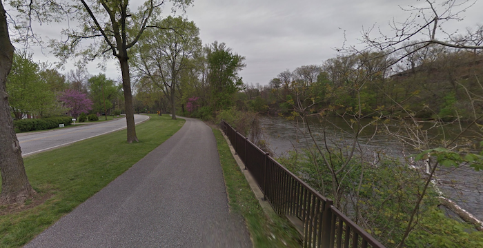
North Section: Riverside Trail. 3.6 miles. The Riverside Trail runs from Darden Rd. @Wheelock Park south to Angela Ave., following Riverside Dr. Crossing the scenic pedestrian bridge at Wheelock Park, the first 1.4 miles to Pinhook Park are away from the water and aren’t as scenic. The next 2.2 miles are lovely, with nice water views, passing through three riverside parks: Pinhook Park, Woodlawn Park, & Keller Park.
Gap: run east for 0.6 miles along Angela Blvd. or south on W North Shore Dr. for 1 mile to connect to the E-bank trail.
Central Section: E-Bank/Northside Trail. 4 miles. This paved trail runs along the east bank of the river, linking the University of Notre Dame and Indiana University South Bend. From Angela Blvd., the first 0.5 miles is away from the water, passing the South Bend Welcome Sign. Then, follow the paved path right alongside the river, enjoying nice views of the water and the South Bend skyline, as you pass through Howard Park and Governor Joseph Kernan Park. At 3 miles, connect to the Northside Trail, which runs for another 1 mile south to W 27th St.
Side Trips: Enjoy the crafstman style homes of Harter Heights, just north of Howard Rd. At Indiana University South Bend off the Northside Trail, explore the campus & pedestrian bridge on the ISSB Bike Trail.
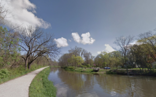
RiverWalk. Google Street View
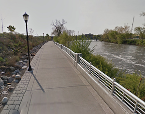
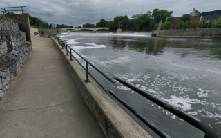
South Section: Mishawaka RiverWalk. 1.5 miles along rive,r or 3.1 mile loop. Among the more scenic sections!Just 0.6 miles south of the Northside Trail, the RiverWalk adds another 1.5 miles along the St. Joseph River in Mishawaka. Run this as part of a longer route along the river, or enjoy the 5k loop. It’s a scenic route, with water views and several parks. From Logan St., run along the north bank through Battell Park & Central Park (additional trails), crossing to the south bank on a pedestrian bridge, passing through Kamm Island Park. Bonus: Lit at night!
One can run almost continuously for ~9 miles on paved paths along St. Joseph River from Darden Rd. to Central Park in Mishawaka. We’ve divided this into three distinct routes, from north to south,. which can be mix & matched.
North Section: Riverside Trail. 3.6 miles. The Riverside Trail runs from Darden Rd. @Wheelock Park south to Angela Ave., following Riverside Dr. Crossing the scenic pedestrian bridge at Wheelock Park, the first 1.4 miles to Pinhook Park are away from the water and aren’t as scenic. The next 2.2 miles are lovely, with nice water views, passing through three riverside parks: Pinhook Park, Woodlawn Park, & Keller Park.
Gap: run east for 0.6 miles along Angela Blvd. or south on W North Shore Dr. for 1 mile to connect to the E-bank trail.
Central Section: E-Bank/Northside Trail. 4 miles. This paved trail runs along the east bank of the river, linking the University of Notre Dame and Indiana University South Bend. From Angela Blvd., the first 0.5 miles is away from the water, passing the South Bend Welcome Sign. Then, follow the paved path right alongside the river, enjoying nice views of the water and the South Bend skyline, as you pass through Howard Park and Governor Joseph Kernan Park. At 3 miles, connect to the Northside Trail, which runs for another 1 mile south to W 27th St.
Side Trips: Enjoy the crafstman style homes of Harter Heights, just north of Howard Rd. At Indiana University South Bend off the Northside Trail, explore the campus & pedestrian bridge on the ISSB Bike Trail.
RiverWalk. Google Street View
South Section: Mishawaka RiverWalk. 1.5 miles along rive,r or 3.1 mile loop. Among the more scenic sections!Just 0.6 miles south of the Northside Trail, the RiverWalk adds another 1.5 miles along the St. Joseph River in Mishawaka. Run this as part of a longer route along the river, or enjoy the 5k loop. It’s a scenic route, with water views and several parks. From Logan St., run along the north bank through Battell Park & Central Park (additional trails), crossing to the south bank on a pedestrian bridge, passing through Kamm Island Park. Bonus: Lit at night!
Scroll Down For Route Maps
Essentials
Up to 9 miles one-way, or done in sections
Fairly flat
Depends on section chosen
Numerous access points & parking areas, depending on section chosen
A lovely 4.4 mile loop in South Bend's downtown area, focused on paths along both banks of the St. Joseph River. There are several parks and some nice river views. A great bet if you're staying downtown! Can add w/additional riverside paths.
Create your own route or use our 5 mile loop to enjoy a run around this historic & attractive campus. Large network of pedestrian paths around academic & residential quads, impressive buildings, two lake loops, and a running track.
A good option to clock in some miles on this paved multi-use path that runs for up to 6.4 miles north to Niles, Michigan. Mainly flat, passing through residential communities.
This 3800-acre state park located 15 miles south of South Bend has something for every runner. 20+ miles of trails, ranging from an easy to more rugged, on a nice variety of terrain, including woods, fields, wetlands, & restored prairie.
Three multi-use trails in Goshen, part of the greater metro area. Our favorite for running is the Milltrace Canal Trail. Or, run for up to 12 miles on the Pumpkinvine Nature Trail, or a less scenic 6 miles between Goshen & Elkhart on the MapleHeart Trail.
In Elkhart, some scenic running on trails along the Elkhart River, including several riverfront parks. We've mapped two routes which can be combined for a 10-miler! We also like running in Ox Bow County Park.
Share your feedback on this route and see that of other Great Runs users. Click on the image icon to upload a photo. And please let us know if there are notes or changes we should incorporate!
Subscribe
0 Comments
Oldest
Newest
Inline Feedbacks
View all comments
Essentials
Up to 9 miles one-way, or done in sections
Fairly flat
Depends on section chosen
Numerous access points & parking areas, depending on section chosen


Review or Comment on This Route/Share a Photo!
Share your feedback on this route and see that of other Great Runs users. Click on the image icon to upload a photo. And please let us know if there are notes or changes we should incorporate!