Queeny Park
About twelve miles west of the city in nearby Chesterfield and Ballwin is Edgar M. Queeny County Park, or Queeny Park. This former estate is now covered with 569 acres of off-road and paved trails, and hosts art fairs during the spring time. Popular among trail runners, the exterior loop covers four miles and is great for those staying a little further west of the city.
Queeny Park Trails
Castlewood State Park
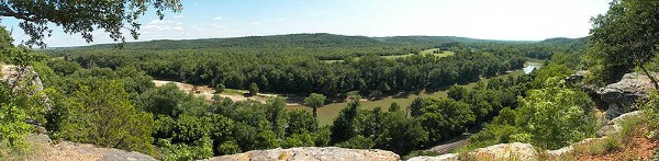
Located 25 miles west of St. Louis, Castlewood State park covers over 1800 acres, and serves as one of the top destinations for recreational wildlife and outdoor enthusiasts in the eastern Missouri area. Frequented by boaters, mountain bikers, and hikers, the popular retreat offers many opportunities for runners, especially those looking for trails and looking for something a little outside the city limits. There are numerous trails of moderate to rugged difficulty, from 1.5 to nearly 7 miles. See link for detailed trail information.
Castlewood Park Trails
Katy Trail (near airport)
The Katy Trail is a 264 mile (386 km) rail-trail stretching across most of the state of Missouri. The west end is in Clinton, MO and the east end is at Wachens (12 miles east of St. Charles). The crushed limestone trail is flat and scenic. The landscape is a combination of woods and farm fields, with some sections along the Missouri River. Over half of the trail follows Lewis and Clark’s path up the Missouri River. The entire trail is part of Katy Trail State Park, so it’s well maintained — there are information kiosks, restrooms, and water fountains at key points along the way. The closest access point to St. Louis is St. Charles.
Katy Trail Information
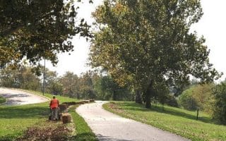
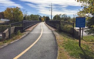
The Monarch Chesterfield Trail
A great option in the suburb of Chesterfield, west of St. Louis. The Monarch Chesterfield Trail is a part of the Missouri Greenway that follows the Bonhomme Creek. The mainly paved trail is built on top of the Monarch Chesterfield Levee, which protects 4,000 acres of land from the waters of the Missouri River. The main trail runs for between River’s Edge Park and Centaur Rd. Our 9.5 mile (one-way) route includes a jaunt over the Boone Bridge, allowing a glimpse of the Missouri River and connection to the Katy Trail. ROUTE MAP TRAIL INFORMATION & MAP
There’s a shorter, non-contiguous spur of the Chesterfield Trail that runs for 2.5 miles from Baxter Rd. to Railroad Park. ROUTE MAP
Busch Greenway
One mile west of the Boone Bridge on the Katy Trail, connect to the Busch Greenway. This 4.3 mile paved trail runs from the Katy Trail to Weldon Spring, terminating near the Weldon Spring Site Interpretive Center. Mainly wooded for the first 2 miles north to Weldon Spring, then more open on the section parallel to Highway 94. ROUTE MAP
Queeny Park
About twelve miles west of the city in nearby Chesterfield and Ballwin is Edgar M. Queeny County Park, or Queeny Park. This former estate is now covered with 569 acres of off-road and paved trails, and hosts art fairs during the spring time. Popular among trail runners, the exterior loop covers four miles and is great for those staying a little further west of the city.
Queeny Park Trails
Castlewood State Park
Located 25 miles west of St. Louis, Castlewood State park covers over 1800 acres, and serves as one of the top destinations for recreational wildlife and outdoor enthusiasts in the eastern Missouri area. Frequented by boaters, mountain bikers, and hikers, the popular retreat offers many opportunities for runners, especially those looking for trails and looking for something a little outside the city limits. There are numerous trails of moderate to rugged difficulty, from 1.5 to nearly 7 miles. See link for detailed trail information.
Castlewood Park Trails
Katy Trail (near airport)
The Katy Trail is a 264 mile (386 km) rail-trail stretching across most of the state of Missouri. The west end is in Clinton, MO and the east end is at Wachens (12 miles east of St. Charles). The crushed limestone trail is flat and scenic. The landscape is a combination of woods and farm fields, with some sections along the Missouri River. Over half of the trail follows Lewis and Clark’s path up the Missouri River. The entire trail is part of Katy Trail State Park, so it’s well maintained — there are information kiosks, restrooms, and water fountains at key points along the way. The closest access point to St. Louis is St. Charles.
Katy Trail Information
The Monarch Chesterfield Trail
A great option in the suburb of Chesterfield, west of St. Louis. The Monarch Chesterfield Trail is a part of the Missouri Greenway that follows the Bonhomme Creek. The mainly paved trail is built on top of the Monarch Chesterfield Levee, which protects 4,000 acres of land from the waters of the Missouri River. The main trail runs for between River’s Edge Park and Centaur Rd. Our 9.5 mile (one-way) route includes a jaunt over the Boone Bridge, allowing a glimpse of the Missouri River and connection to the Katy Trail. ROUTE MAP TRAIL INFORMATION & MAP
There’s a shorter, non-contiguous spur of the Chesterfield Trail that runs for 2.5 miles from Baxter Rd. to Railroad Park. ROUTE MAP
Busch Greenway
One mile west of the Boone Bridge on the Katy Trail, connect to the Busch Greenway. This 4.3 mile paved trail runs from the Katy Trail to Weldon Spring, terminating near the Weldon Spring Site Interpretive Center. Mainly wooded for the first 2 miles north to Weldon Spring, then more open on the section parallel to Highway 94. ROUTE MAP


Review or Comment on This Route/Share a Photo!
Share your feedback on this route and see that of other Great Runs users. Click on the image icon to upload a photo. And please let us know if there are notes or changes we should incorporate!