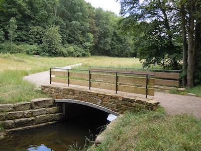
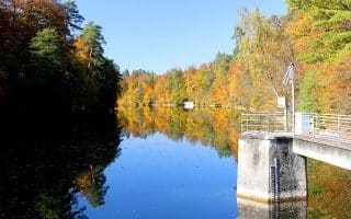
There are three adjoining green spaces in southern Stuttgart, near the airport, that make for a nice run. Furthest west is Weidach- und Zettachwald, a large nature preserve with a series of trails through forests and meadows. There’s a combination of wide gravel roads and some slightly rugged trails that are more for hiking/trail running.
Weidach- und Zettachwald. Creative Commons
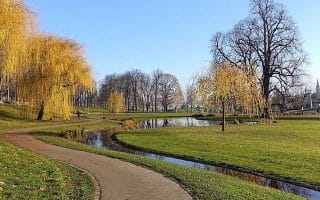
Just east of there is Hohenheimer Garden, large arboretum/botanical garden, with numerous pleasant paths for walking. Don’t miss the tree-lined Jägerallee. Also, you can explore the paths around the campus of the University of Hohenheim, just to the north. Then, just east of the botanical garden are the mainly wooded paths in the Häslachwald nature preserve.
We’ve mapped a route that combines and connects these three areas, to use as a guideline. Once in each of these three spots, there are numerous additional trails to explore. It’s ~7 km west to east.
STAY: Good selection of hotels on the west side of Weidach- und Zettachwald, near the highway. Also, a cluster of hotels in between the Hohenheimer Garden and Highway 8.
There are three adjoining green spaces in southern Stuttgart, near the airport, that make for a nice run. Furthest west is Weidach- und Zettachwald, a large nature preserve with a series of trails through forests and meadows. There’s a combination of wide gravel roads and some slightly rugged trails that are more for hiking/trail running.
Weidach- und Zettachwald. Creative Commons
Just east of there is Hohenheimer Garden, large arboretum/botanical garden, with numerous pleasant paths for walking. Don’t miss the tree-lined Jägerallee. Also, you can explore the paths around the campus of the University of Hohenheim, just to the north. Then, just east of the botanical garden are the mainly wooded paths in the Häslachwald nature preserve.
We’ve mapped a route that combines and connects these three areas, to use as a guideline. Once in each of these three spots, there are numerous additional trails to explore. It’s ~7 km west to east.
STAY: Good selection of hotels on the west side of Weidach- und Zettachwald, near the highway. Also, a cluster of hotels in between the Hohenheimer Garden and Highway 8.
Scroll Down For Route Maps
Essentials
It's 7 km (4 miles) west to east connecting the three areas. Create your own route on the trails within the areas
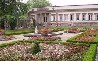
Run the grounds of Stuttgart’s old palace at the “Schlossgarten,” a collection of three manicured parks in the heart of the city. Routes up to 7 km can be combined with the Neckar River and Rosenstein Park runs.
Rosenstein Park abuts the Zoo & Botanical Garden with a paved loop around Rosenstein Palace and Lion’s Gate. Connect to Wartberg Park & Höhenpark Killesberg, or the Castle Gardens & Neckar River paths.
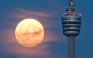
Enjoy some of the best views in Stuttgart from this run to the top of the Fernsehturm Stuttgart TV Tower on Hoher Bopser. 6.5 km of hard packed dirt trail with plenty of add on opportunities. Oval running track located in the area!
A 5 km on a stone paved pathway, the pastoral Schimmelhüttenweg is a 5 km out and back path through the Degerlocher Scharrenberg vineyard. Great views of the city from the vineyards surrounding the historic site of the Weissenburg Castle.
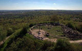
Follow the spiraling incline to the top of “Rubble Mountain” for fantastic views of the city and a look at a collection of historic remnants from WWII. 5 km out and back with lots of additions.
The course of Parkrun loops through Kräherwald Park, a hilly forested ridge with numerous trail running options. Start from MTV Stuttgart and run the 5 km course or a longer loop.
Run the highlights of the Rösslesweg, a more than 50 km loop around the Stuttgart hillside. The best sections include Bad Cannstatt to Untertuerkheim and the Birkenkopf.
Share your feedback on this route and see that of other Great Runs users. Click on the image icon to upload a photo. And please let us know if there are notes or changes we should incorporate!
Subscribe
0 Comments
Oldest
Newest
Inline Feedbacks
View all comments
Essentials
It's 7 km (4 miles) west to east connecting the three areas. Create your own route on the trails within the areas


Review or Comment on This Route/Share a Photo!
Share your feedback on this route and see that of other Great Runs users. Click on the image icon to upload a photo. And please let us know if there are notes or changes we should incorporate!