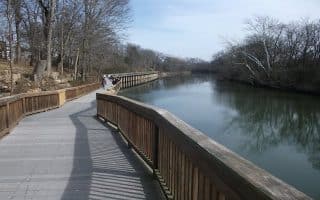
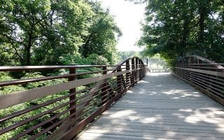
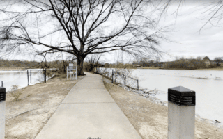
Shelby Bottoms Greenway is a beautiful, paved trail with impressive views of the Cumberland River. As you run along the river, keep your eye out for Spot Opryland’s General Jackson Riverboat. The trail is nearly 4 miles one-way, with quarter-mile markers. It’s a good bet in hot weather due to nice shade. The Nature Center is a 15 minute drive East of the city, with plenty of parking. The northern terminus of the trail is just south of Opryland. Across the river is also Wave Country Water Park and a public golf course.
Greenway Trail Map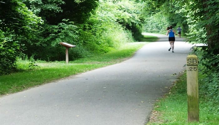
Features:
Categories:
Scroll Down For Route Maps
Essentials
- 7.8 miles out-and-back.
- Flat
- Shelby Park Nature Center
Current Weather & Forecast

Nashville, US
6:11 pm,
Jun 3, 2026
L: 27°
H: 28°
Daily ForecastHourly Forecast
Tomorrow
4:00 pm
27° / 28°°C
1 mm
100%
22 mph
86 %
1006 mb
0 mm/h
Friday
4:00 pm
11° / 17°°C
1 mm
100%
16 mph
88 %
1016 mb
0 mm/h
Saturday
4:00 pm
10° / 20°°C
1 mm
100%
18 mph
87 %
1015 mb
0 mm/h
Sunday
4:00 pm
12° / 18°°C
0.2 mm
20%
20 mph
82 %
1022 mb
0 mm/h
Monday
4:00 pm
12° / 22°°C
0.2 mm
20%
15 mph
84 %
1021 mb
0 mm/h
Today
7:00 pm
14° / 16°°C
1 mm
100%
14 mph
82 %
1003 mb
0 mm/h
Today
10:00 pm
14° / 15°°C
1 mm
100%
16 mph
85 %
1003 mb
0 mm/h
Tomorrow
1:00 am
15° / 15°°C
1 mm
100%
17 mph
86 %
1002 mb
0 mm/h
Tomorrow
4:00 am
18° / 18°°C
1 mm
100%
20 mph
78 %
1001 mb
0 mm/h
Tomorrow
7:00 am
16° / 16°°C
1 mm
100%
22 mph
74 %
1001 mb
0 mm/h
Tomorrow
10:00 am
20° / 20°°C
1 mm
100%
20 mph
64 %
1002 mb
0 mm/h
Tomorrow
1:00 pm
16° / 16°°C
1 mm
100%
20 mph
79 %
1003 mb
0 mm/h
Other Routes in Nashville, TN
An overview of some of Nashville's prettiest residential neighborhoods for running, adapted from Neighborhoods.com: Belle Meade, Belmont-Hillsboro, Sylvan Park, and East Nashville. Pretty streets, homes, history.
A tour of downtown, several 'country music' sights, and paths/greenways, including the Cumberland River Greenway and the East Bank Greenway. Shorter & longer versions, all accessible from downtown. Cherry blossoms in spring!
A flat, 6.6 mile one-way trail, between the Country Music Hall of Fame, north to Rhodes Park. Some parts alongside the road and some on the river, with options to cross over to the east side in sections.

A great tour of some of the music landmarks of Nashville, including Music Square East and West, the Wyatt Center, and Owen Bradley Park. Campus of Vanderbilt University is a nice add-on.

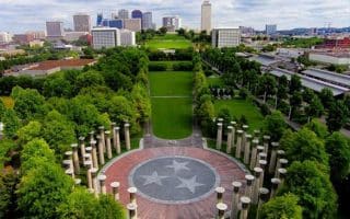
A nice run combining Centennial Park, home to Nashville’s Parthenon — a replica of the Athenian Parthenon and featuring American art galleries, with the 300-acre Vanderbilt campus, which doubles as an arboretum. Also a running track.
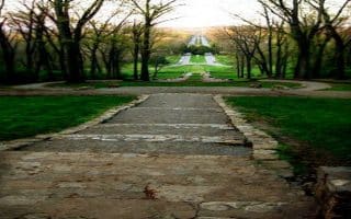
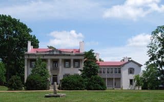
2600 acres of forest and field located minutes south of downtown. The historic entrance is marked by “The Allee”, an impressive set of stone steps, leading to great views of the Nashville skyline. Can also connect to Harpeth River Greenway. Popular 11.2 mile road loop option.
A multi-use trail that runs parallel to the Stones River for much of its length. 12 miles east of downtown and 5 miles south of the airport, and connects to the Shelby Bottoms Greenway.
One of many of Nashville’s evolving system of greenways, about 15 minutes West of downtown. The multi-use trail loops around McCabe Park, along Richland Creek, and a section cool for railroad buffs.
A multi-use trail in the city of Brentwood, features rolling hills and a wide, paved path. Includes River Park, a section along the Little Harpeth River, and Crockett Park.

Three multi-use trails in cities north of Nashville that are nice for running: the 4.5 mile Hendersonville Greenway along the Columbia River through two parks; the 3.8 mile White House Greenway, and the 2.5 mile Springfield Greenway.
This historic town 20 miles south of Nashville has some nice running! Combine Pinkerton Park, Fort Granger, downtown, & the Franklin Greenway for an 8-miler. The Park at Harlinsdale Farm is a historic horse farm with a 5k soft track across rolling farmland.

Run the section of this 444-mile recreational road and scenic drive that passes close to Nashville. The road is also a designated cycling road, so it's runnable. Pretty views and foliage. A dirt trail runs alongside the road from Franklin to Garrison Creek.
User Ratings
Leave A Review or Comment
Review or Comment on This Route/Share a Photo!
Share your feedback on this route and see that of other Great Runs users. Click on the image icon to upload a photo. And please let us know if there are notes or changes we should incorporate!