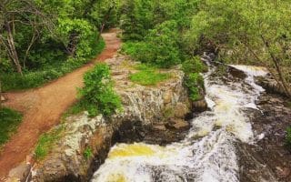
Jay Cooke State Park is located 18 miles south of Duluth, and offers some of the most extensive trails for running in the area. Enjoy running through hardwood forests, viewing the park’s gorges, steep valleys, and massive rock formations. There are 8 miles of paved multi-use trails, 50 miles of hiking trails, and 13 miles of mountain biking trails. See attached trail map for trail information.
For runners, there’s something for everyone here. Some recommendations for easy-to-moderate running:
Swinging Bridge. Flickr: Steve Moses
William Munger State Trail. A section of this 70 mile, paved multi-use trail runs through the park. Two options, both of them straight and fairly flat: Starting in Carlton, head east, along the northern edge of the park, for many miles. It’s up to 9 miles one-way to Becks Rd./Short Line Park. Or, head south, mostly paralleling Rt. 1, for 6+ miles to Rt. 23. This direction alternates between wooded and open.
CCC Trail: 1.8 mile loop. Starts behind the River Inn. Nice views of the St. Louis River.
Silver Creel Trail. Great for trail runners. Some hills but not too challenging. The 3.5 mile loop crosses the Swinging Bridge and follows a wide grassy route through birch and basswood trees, with views of the St. Louis River and Silver Creek.
Jay Cooke State Park is located 18 miles south of Duluth, and offers some of the most extensive trails for running in the area. Enjoy running through hardwood forests, viewing the park’s gorges, steep valleys, and massive rock formations. There are 8 miles of paved multi-use trails, 50 miles of hiking trails, and 13 miles of mountain biking trails. See attached trail map for trail information.
For runners, there’s something for everyone here. Some recommendations for easy-to-moderate running:
Swinging Bridge. Flickr: Steve Moses
William Munger State Trail. A section of this 70 mile, paved multi-use trail runs through the park. Two options, both of them straight and fairly flat: Starting in Carlton, head east, along the northern edge of the park, for many miles. It’s up to 9 miles one-way to Becks Rd./Short Line Park. Or, head south, mostly paralleling Rt. 1, for 6+ miles to Rt. 23. This direction alternates between wooded and open.
CCC Trail: 1.8 mile loop. Starts behind the River Inn. Nice views of the St. Louis River.
Silver Creel Trail. Great for trail runners. Some hills but not too challenging. The 3.5 mile loop crosses the Swinging Bridge and follows a wide grassy route through birch and basswood trees, with views of the St. Louis River and Silver Creek.
Scroll Down For Route Maps
Essentials
Depends on route chosen
Options for flat or hilly!
Park entrance near Carlton is a good starting point
Among the signature places to run in Duluth. The multi-use path follows Rt. 61 along Lake Superior from the Canal Park area for 7.5 miles, north to Brighton Beach. There are spectacular views of the lake, especially for the first 4 miles.
For those who want a longer, straightforward waterfront run, this is a good bet! We've mapped a 7.5 mile section of North Shore Drive along Lake Superior, starting near Brighton Beach and heading north to Palmers. Wide shoulders and water views.
This neighborhood features some really nice variety for running in Duluth. Quiet residential streets with nice homes, trails in Lester Park, Amity Park, and the Hawk Ridge Nature Reserve. We've also mapped a lovely 10k parkway road run.
A scenic tour of Duluth's lovely waterfront and downtown area. Highlights include the Canal Park area, Bayfront Festival Park, the Aerial Lift Bridge, N&S Piers, a section of the Lakefront Trail, and some downtown streets & Civic Center area.
This long, narrow sand spit that extends out from Canal Park, makes for a nice run. Combination of road and 2-mile long Nature Trail, that ends at the spectacular point of the Superior Entry Channel. Note: sections of Nature Trail are soft sand!
Lots of variety in one run! Flat, waterfront section of the Superior Hiking Trail starts in Bayfront Festival Park, goes for 1 mile, then continues for 2.4 miles on a hilly, gravel trail between Central Park and Enger Park, with views from the Tower as a reward.
A wooded and quite challenging trail run right near downtown. The Chester Park Trail is a wooded and steep ~3 mile loop, going up and down ravines. The Univ. of Minnesota at Duluth, just east of the park, has a nice campus and track for running.
A 640-acre park featuring more than 10 miles of mainly wooded multi-use trails. Mainly trail running and quite hilly. Use attached map to create your own route. The Woodland and Hunters Park neighborhoods adjacent to the park are also pleasant for running.
Great option for a flat off-road run on this collection of multi-use trails between Duluth and Hinckley. Starting near the Superior Zoo, it's 6 miles to Short Line Park, and another 6 miles to Jay Cooke State Park. Terrain is mainly wooded, with some giant rock formations.
Share your feedback on this route and see that of other Great Runs users. Click on the image icon to upload a photo. And please let us know if there are notes or changes we should incorporate!
Subscribe
0 Comments
Oldest
Newest
Inline Feedbacks
View all comments
Essentials
Depends on route chosen
Options for flat or hilly!
Park entrance near Carlton is a good starting point







Review or Comment on This Route/Share a Photo!
Share your feedback on this route and see that of other Great Runs users. Click on the image icon to upload a photo. And please let us know if there are notes or changes we should incorporate!