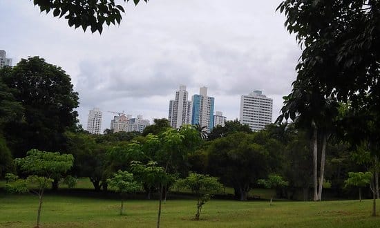
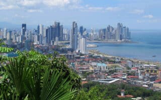
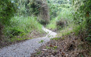
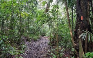
For locals who live inland from the Cinta Costera, the go-to running option is the Parque Omar Torrijos. Located off Via Porras in the northeast section, it’s the second largest green space in Panama City. There are murals, playing fields, and miles of paved running trail. A loop around the park’s main circuit is 3.5 km, though there are plenty of rolling hills to keep runners interested. There are also free fitness classes daily, so you can round out your workout with Zumba and other aerobic programs if you so desire!
Scroll Down For Route Maps
Essentials
- 3.5 km (2.2 miles) loop
- 43 meters (142 feet)
- Park Entrance
- Parque Omar Bus Stop
Current Weather & Forecast

Panama City, PA
6:51 pm,
Jun 3, 2026
L: 26°
H: 26°
Daily ForecastHourly Forecast
Tomorrow
4:00 pm
13° / 16°°C
1 mm
100%
28 mph
89 %
1006 mb
0 mm/h
Friday
4:00 pm
11° / 15°°C
0 mm
0%
19 mph
85 %
1014 mb
0 mm/h
Saturday
4:00 pm
12° / 14°°C
1 mm
100%
29 mph
92 %
1014 mb
0 mm/h
Sunday
4:00 pm
12° / 15°°C
0 mm
0%
20 mph
79 %
1022 mb
0 mm/h
Monday
4:00 pm
13° / 16°°C
1 mm
100%
17 mph
93 %
1018 mb
0 mm/h
Today
7:00 pm
14° / 14°°C
0.79 mm
79%
28 mph
89 %
998 mb
0 mm/h
Today
10:00 pm
14° / 14°°C
1 mm
100%
26 mph
88 %
998 mb
0 mm/h
Tomorrow
1:00 am
13° / 13°°C
1 mm
100%
28 mph
87 %
997 mb
0 mm/h
Tomorrow
4:00 am
14° / 14°°C
1 mm
100%
26 mph
83 %
998 mb
0 mm/h
Tomorrow
7:00 am
16° / 16°°C
1 mm
100%
22 mph
86 %
998 mb
0 mm/h
Tomorrow
10:00 am
16° / 16°°C
1 mm
100%
22 mph
76 %
1001 mb
0 mm/h
Tomorrow
1:00 pm
16° / 16°°C
1 mm
100%
21 mph
74 %
1003 mb
0 mm/h
Other Routes in Panama City, Panama


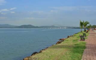
Panama City’s signature running option, the Ciclovia Cinta Costera is one of the finest waterfront running routes in Latin America. This paved path is in great condition, stretching more for 8+ km between Estadio Maracana in the south and Democracy Plaza in the north.
A lovely paved multi-use path - either a 5 km one way or a 10 km out and back. Island hop along the causeway from Amador to Naos, Parico, and Flamenco islands.
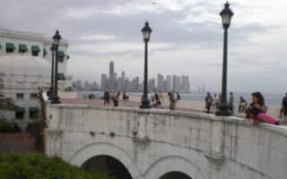
A 'runseeing tour' of Panama City’s old city, built in 1673 after pirates destroyed the original settlement. Enjoy the rich history, waterfront views, and fascinating architecture on this 6 km tour.
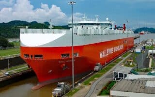
Run along the historic Panama Canal! There are not many runnable roads/trails in this area, but we’ve mapped a 4 km out and back around the Miraflores Locks.
Some of the best views in Panama City come from the top of Cerro Ancón, a 654 foot hill in city's south end. A run to the summit is 2 km one-way on a paved, car-free road. Steep grades! We've also mapped a longer option.
This 232 hectare space bordering the west part of Panama City is the only Central American tropical forest located within city limits. The park trails are great for running and can be combined for a route of up to 5 km.
There is plenty of trail running in Camino de Cruces and Soberanía national parks. The most popular is the Camino de Cruces trail to the Venta de Cruces ruins, which is 11 km one-way. There are other, shorter options too
User Ratings
Leave A Review or Comment
Review or Comment on This Route/Share a Photo!
Share your feedback on this route and see that of other Great Runs users. Click on the image icon to upload a photo. And please let us know if there are notes or changes we should incorporate!