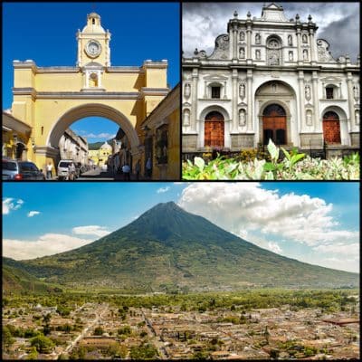
It’s a special experience to create your own run on the streets of Antigua Guatemala, the city in the central highlands of Guatemala known for its preserved Spanish Baroque-influenced architecture and ruins of colonial churches. Located 30 km from Guatemala City and accessible by bus, this UNESCO World Heritage site is surrounded by three enormous volcanoes and mountains, plains and hills. If you’d like to have an in-person guided running experience in Antigua Guatemala, we highly recommend our friends at Go! Running Tours.
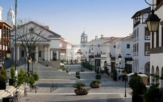
The most ‘runnable’ run in Antigua is to do a tour of the largely pedestrianized old town. It’s laid out in an easy to follow square pattern, so easy to follow! This is also the only way to do a relatively flat run in the area. Just outside of town, things get hilly and rugged really quickly! Start in Central Park (Plaza Mayor) and explore the streets north-south, ~1 km between C. de Las Animas 3 & 9 Calle Oriente, and ~1 km east-west between 1a Avenida Nte & Alameda de Santa Lucia. Notes: the streets have a mainly cobblestone surface. Also, runners should be aware of Antigua’s elevation at 5,000 feet.
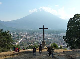
Hill of the Cross. I, Ondřej Žváček
Additionally, you can run to the Hill of the Cross (Cerro de La Cruz), which offers great views of the city and the Volcan Agua. This will get the heart rate up! From Plaza Mayor, it’s 1.6 km, climbing 121m. Use 1a Avenida Nte to head north, then left at the park to get to the Cross.
Hill/Trail Running Outside of Town. Once outside central Antigua, things get rugged and hilly very quickly. There’s a good network of hiking trails just outside of town that are terrific for trail running. Southeast of town, check out the Carmona Trails, and the the Finca El Pilar. In the shadow of Volcan Agua (11.500 foot summit reachable by hike), there are trails in the Finca La Soledad, Alotenango Sacatepéquez & Cafetalera las Marías hiking areas.
It’s a special experience to create your own run on the streets of Antigua Guatemala, the city in the central highlands of Guatemala known for its preserved Spanish Baroque-influenced architecture and ruins of colonial churches. Located 30 km from Guatemala City and accessible by bus, this UNESCO World Heritage site is surrounded by three enormous volcanoes and mountains, plains and hills. If you’d like to have an in-person guided running experience in Antigua Guatemala, we highly recommend our friends at Go! Running Tours.
The most ‘runnable’ run in Antigua is to do a tour of the largely pedestrianized old town. It’s laid out in an easy to follow square pattern, so easy to follow! This is also the only way to do a relatively flat run in the area. Just outside of town, things get hilly and rugged really quickly! Start in Central Park (Plaza Mayor) and explore the streets north-south, ~1 km between C. de Las Animas 3 & 9 Calle Oriente, and ~1 km east-west between 1a Avenida Nte & Alameda de Santa Lucia. Notes: the streets have a mainly cobblestone surface. Also, runners should be aware of Antigua’s elevation at 5,000 feet.
Hill of the Cross. I, Ondřej Žváček
Additionally, you can run to the Hill of the Cross (Cerro de La Cruz), which offers great views of the city and the Volcan Agua. This will get the heart rate up! From Plaza Mayor, it’s 1.6 km, climbing 121m. Use 1a Avenida Nte to head north, then left at the park to get to the Cross.
Hill/Trail Running Outside of Town. Once outside central Antigua, things get rugged and hilly very quickly. There’s a good network of hiking trails just outside of town that are terrific for trail running. Southeast of town, check out the Carmona Trails, and the the Finca El Pilar. In the shadow of Volcan Agua (11.500 foot summit reachable by hike), there are trails in the Finca La Soledad, Alotenango Sacatepéquez & Cafetalera las Marías hiking areas.
Scroll Down For Route Maps
Essentials
Several km possible in central Antigua -- it's 1 km n-s & 1 km e-w. Run to Cross is a 3 km loop
Flat in central Antiqua. Run to the cross is 100+m
Of our two main routes through downtown Guatemala City, this 'runseeing tour' heads north from the Centro Civico through the historic centre, then through Jocotenango Park to the Relief Map. Can combine with southern route.
Of our two main routes through downtown Guatemala City, this route is focused on the section headed south from the Centro Civico along Avenida La Reforma & Parque Las Americas.
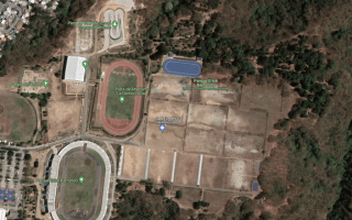
The largest park in the city and a decent place for a run in Zone 7. There are sports fields, and an excellent running track. It's a ~3.2 km loop around the park perimeter.
The Universidad de San Carlos campus is one of the better off-road spots in Guatemala City for a run. Pleasant pedestrian paths, small parks, and a running track. Av. Petapa just to the east also runnable.
It's possible to stitch together a quite pleasant ~5 mile run in the upscale Cayala district in Zone 16, combining Plaza Cayala, Blvd. Rafael Landivar, and the green median along Blvd. Vista Hermosa. Hilly!
Share your feedback on this route and see that of other Great Runs users. Click on the image icon to upload a photo. And please let us know if there are notes or changes we should incorporate!
Subscribe
0 Comments
Oldest
Newest
Inline Feedbacks
View all comments
Essentials
Several km possible in central Antigua -- it's 1 km n-s & 1 km e-w. Run to Cross is a 3 km loop
Flat in central Antiqua. Run to the cross is 100+m

Review or Comment on This Route/Share a Photo!
Share your feedback on this route and see that of other Great Runs users. Click on the image icon to upload a photo. And please let us know if there are notes or changes we should incorporate!