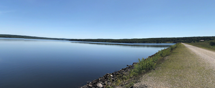
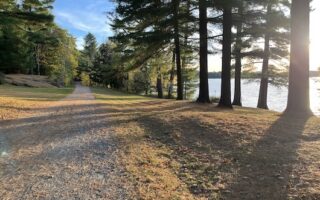
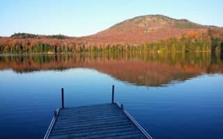
Yamaska National Park is a gem for running in the Eastern Townships. The provincial park is centered on the man-made Choinière Reservoir in the Roxton Pond area, 10 km east of Granby. There’s something for everyone here, from a paved, 19 km cycling path to several km of trails of varying difficulty. This trail map (in french) is a helpful resource (see Sentiers d’été). Note: Trails used for winter activities in winter.
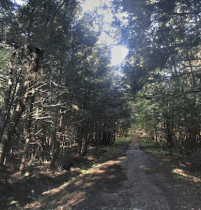
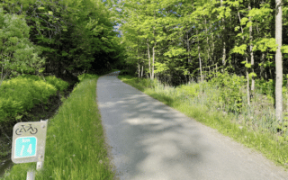
Woods trail. Google Street View
For an easier run, choose a section of the 19 km Le Grand-Tour trail around the Reservoir. It’s a flat, gravel path, fairly wooded. The best water views are some sections on the west and south ends of the reservoir.
There are numerous other trails, generally easy footing, with loops ranging from 2.5 km to 10.3 km. A favorite in autumn or after a fresh snowfall in winter is the 5.5 km La Forestière loop.
You can also take paved bike path along the Yamaska River (Piste Cyclabe du Parc régional de la Haute Yamaska) for 7.5 km west to Granby, or the stone dust surface Campagnarde cycle path south for 11 km toward Waterloo.
Yamaska National Park is a gem for running in the Eastern Townships. The provincial park is centered on the man-made Choinière Reservoir in the Roxton Pond area, 10 km east of Granby. There’s something for everyone here, from a paved, 19 km cycling path to several km of trails of varying difficulty. This trail map (in french) is a helpful resource (see Sentiers d’été). Note: Trails used for winter activities in winter.
Woods trail. Google Street View
For an easier run, choose a section of the 19 km Le Grand-Tour trail around the Reservoir. It’s a flat, gravel path, fairly wooded. The best water views are some sections on the west and south ends of the reservoir.
There are numerous other trails, generally easy footing, with loops ranging from 2.5 km to 10.3 km. A favorite in autumn or after a fresh snowfall in winter is the 5.5 km La Forestière loop.
You can also take paved bike path along the Yamaska River (Piste Cyclabe du Parc régional de la Haute Yamaska) for 7.5 km west to Granby, or the stone dust surface Campagnarde cycle path south for 11 km toward Waterloo.
A multitude of running options in this town of 70,000 at the western edge of the Townships: Loops around Lac Boivin, Nature Center trails, Yamaska River cycle path, & Estriade cycle path.
Choose from several great running options in Waterloo: A 1.6 km lake loop; the 22 km Estriade Path west to Granby; 11 km Campagnarde Path to Yamaska National Park; and the Lac-Brome path south toward Knowlton.
Pleasant multi-use path runs between Knowlton and Waterloo. Combination of wooded and open landscape, with nice some nice views of Brome Lake over the first 5 km to Argyll Rd. Beautiful in fall!
The 13 km section of the Route Verte (Quebec's long-distance cycle path) that runs between North Hatley and Lennoxville is a terrific option option for those who'd like a long, flat off-road run on a good surface. Woods, fields, & farms.
An easy trail run through a 70-acre Old Growth forest just northwest of downtown Sherbrooke! There are 6.1 km of wide, gravel trails through an old maple grove and beech forest.
Nice waterside run along the Rivière aux Cerises and Lake Memphremagog for 5 km on the La Montagnarde and Route Verte multi-use paths. For more, continue on La Route Verte, or run in Mont-Orford National Park, just north of Magog.
This large provincial park is one of the premier outdoor recreation destinations in the Eastern Townships. 80 km of trails, with something for runners of all abilities. Easier options are the Des Trois-Étangs Loop & the La Cavalière bike path.
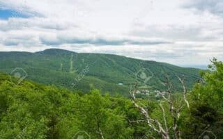
Popular ski area in the heart of the Townships has 52 km of trails that are popular for mountain biking, hiking, and trail running in summer. There are trail runs ranging from easy to advanced, though ALL are hilly. Gorgeous in autumn.
Share your feedback on this route and see that of other Great Runs users. Click on the image icon to upload a photo. And please let us know if there are notes or changes we should incorporate!
Review or Comment on This Route/Share a Photo!
Share your feedback on this route and see that of other Great Runs users. Click on the image icon to upload a photo. And please let us know if there are notes or changes we should incorporate!