Vienna has a large number of extensive parks within about 10 km from the city. Many of them present wonderful opportunities for running. Below are our top picks. Thanks to Savoteur Vienna for their help with this selection.
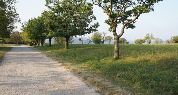
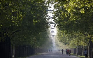
Pötzleinsdorfer Schloßpark. 18th district, 10km northwest of the city. Tramline 41. Wonderful gardens, and giant sequoias lining the avenue that used to be the main entrance to the palace. About 3 km of paths. Particularly pretty in spring, when azaleas and rhododendrons are in bloom. Good to combine with Pötzleinsdorfer Castle-park, 1 km away, with several km of paths, or with 300 meter Hackenberg Hill, from Sieveringer cemetery and ending at Sieveringer Straße.
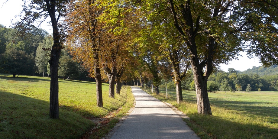
Schwarzenbergpark. Next to Pötzleinsdorfer Schloßpark. Accessible by Tram 43. Wonderful opportunities for trail running and hills. Also enjoy the Schwarzenbergallee, lined with trees. To cover a full 7-kilometer distance, you’ll have to run up to the Jagdhütte at the Grünbergwiese.
Lainzer Tiergarten. 6,000 acre wildlife preserve, dating back to 1561, in the 13th district, about 13 km southwest of the city. Great mix of paved and gravel paths and trails. 22 km wall around the park. 7 gates. Parts only open March-November. NEW (2025): The network of trails has been expanded.
Steinhofgründe. Park 12 km west of Vienna, and near Tiergarten. Park with church and about 3 km around the perimeter paths. Gentle hills, fruit trees, meadows, and for hill lovers, a staircase on the east side of the wall.
Wienerberg Park. Pleasant park and recreation area 10 km southwest of the city. Wooded trails, fields, and a lake. About 3.2 km (2 miles) around the perimeter paths. Predefined running-checkpoints. Reachable by Light Rail 67, 65A, 261 and 265 bus lines.
Wienerwald (Vienna Woods). Forested highlands that form the northeastern foothills of the Northern Limestone Alps in the states of Lower Austria and Vienna. Huge area, comprising 30,000 acres and seven Viennese districts, some 45 km (28 mi) long and 20–30 km (12–19 mi) wide. Designated a Biosphere Reserve by UNESCO. Extensive walking and hiking trails, including woodlands, meadows, pastures, fields and vineyards.
Vienna has a large number of extensive parks within about 10 km from the city. Many of them present wonderful opportunities for running. Below are our top picks. Thanks to Savoteur Vienna for their help with this selection.
Pötzleinsdorfer Schloßpark. 18th district, 10km northwest of the city. Tramline 41. Wonderful gardens, and giant sequoias lining the avenue that used to be the main entrance to the palace. About 3 km of paths. Particularly pretty in spring, when azaleas and rhododendrons are in bloom. Good to combine with Pötzleinsdorfer Castle-park, 1 km away, with several km of paths, or with 300 meter Hackenberg Hill, from Sieveringer cemetery and ending at Sieveringer Straße.
Schwarzenbergpark. Next to Pötzleinsdorfer Schloßpark. Accessible by Tram 43. Wonderful opportunities for trail running and hills. Also enjoy the Schwarzenbergallee, lined with trees. To cover a full 7-kilometer distance, you’ll have to run up to the Jagdhütte at the Grünbergwiese.
Lainzer Tiergarten. 6,000 acre wildlife preserve, dating back to 1561, in the 13th district, about 13 km southwest of the city. Great mix of paved and gravel paths and trails. 22 km wall around the park. 7 gates. Parts only open March-November. NEW (2025): The network of trails has been expanded.
Steinhofgründe. Park 12 km west of Vienna, and near Tiergarten. Park with church and about 3 km around the perimeter paths. Gentle hills, fruit trees, meadows, and for hill lovers, a staircase on the east side of the wall.
Wienerberg Park. Pleasant park and recreation area 10 km southwest of the city. Wooded trails, fields, and a lake. About 3.2 km (2 miles) around the perimeter paths. Predefined running-checkpoints. Reachable by Light Rail 67, 65A, 261 and 265 bus lines.
Wienerwald (Vienna Woods). Forested highlands that form the northeastern foothills of the Northern Limestone Alps in the states of Lower Austria and Vienna. Huge area, comprising 30,000 acres and seven Viennese districts, some 45 km (28 mi) long and 20–30 km (12–19 mi) wide. Designated a Biosphere Reserve by UNESCO. Extensive walking and hiking trails, including woodlands, meadows, pastures, fields and vineyards.
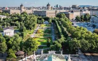
Famed 'Ring Road' is a 6 km loop built along the former medieval city fortifications. It' a great opportunity to see many important Vienna landmarks, while getting a workout in! Best to go early. Video excerpts!
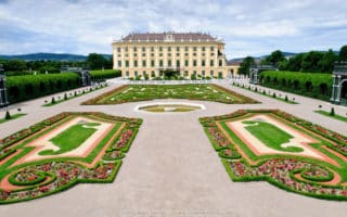
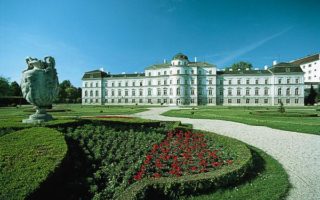
Former imperial summer residence, about 8km west of central Vienna. Perimeter path is about 3 miles around, or enjoy zig-zagging around the gravel palace garden paths, which are free of charge.
Classic European park dating back to 1766, with several attractions including a huge Ferris wheel. The tree-lined, straight 4.5 km Hauptallee is the running highlight and where Eliud Kipchoge ran a sub-2 hour marathon in 2019. Also the Prater Trail.
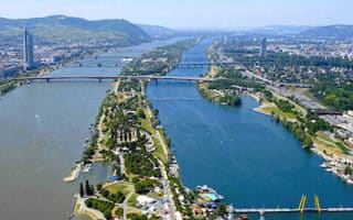
Pleasant running along the Danube River, part of Vienna's waterside 'trio'. About 6km from north to south, with paths on either side of the river, and numerous opportunities to cross and form a loop.
Wide open paved path along Danube Island, 21.8 km from tip to tip. Accessible from numerous subway stations and bridges. Sections near tip are more remote. Popular recreation & restaurant/bar area.
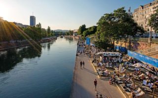
Path, known as Donaukanal, along the Danube Canal. The main path goes for about 4 miles, through the central part of Vienna, with options on either side of the water.
Baroque style park, with palace, playing fields, and elaborate flower gardens. Gravel paths and impressive shady avenues of chestnut, lime, ash, and maple crisscross the park. 130 acres, 3km perimeter.
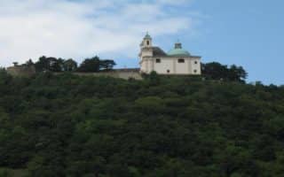
Vienna's most famous hill is a steep, 1 mile climb to a church at the summit, with great views. Grades of nearly 20%! Good add-on to Danube river paths, or pleasant farmland roads in the area.
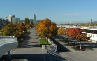
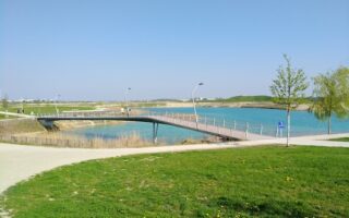
A nice place to run in the newly developing Seestadt Aspern area of eastern Vienna. A loop around the lake & ancillary paths is ~3 km. Nice water views. Add with other ped-friendly roads in the area.
Share your feedback on this route and see that of other Great Runs users. Click on the image icon to upload a photo. And please let us know if there are notes or changes we should incorporate!


Review or Comment on This Route/Share a Photo!
Share your feedback on this route and see that of other Great Runs users. Click on the image icon to upload a photo. And please let us know if there are notes or changes we should incorporate!