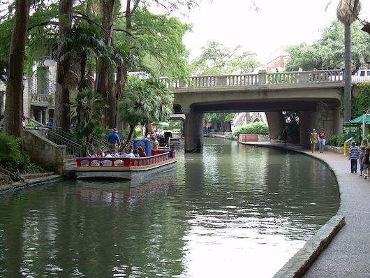
The San Antonio River Walk is both a major visitor attraction and a great place to run. In the early 20th century, a flood along the San Antonio River caused massive damage to the area. In the years that followed, efforts were made to prevent the flooding including the construction of the Olmos Dam and a bypass channel. Over time, the River Walk was constructed, revitalizing the San Antonio downtown area. Today, the River Walk is a major attraction, with many historical sites located along the route, plus a festive scene of boat tours, bars, restaurants, and hotels. RIVER WALK INFO
Overall, the River Walk is about 15 miles, between the San Antonio Zoo to the north and the Mission Espada/I-410 in the south. It’s paved the entire way. There are three distinct sections: downtown loop in the Alamo area; River Walk North/Museum Reach; and the South (Mission Reach) section, which passes several parks and 18-century missions. The path is mainly paved, there are mile markers, and there are many parts that have trails on both sides of the river. There are some tributary trails coming off the River Walk, and a couple of on-road sections. This TRAIL MAP shows all the trail sections and the key sites along the way. From downtown/Alamo area, the path extends ~4.5 miles north and ~10 miles south. We’ve created two route maps: Downtown loop & South; and from Downtown North.
Downtown Loop (1-1.5 miles)
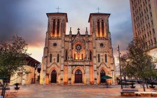
There’s also a 1 mile loop section of the River Walk in downtown San Antonio that comes off the main north-south flow of the San Antonio River. This is the most ‘touristy’ area. See the Alamo, Tower of the Americas, Convention Center, Briscoe Western Art Museum, & San Fernano Cathedral. The path is mainly below the road grade.
North Section (~5 miles)
From Alamo Plaza, the north section, known as the River Walk Expansion/Museum Reach. Running north and mostly below the road grade in the sections closest to downtown, the route will take you past Hugman Dam, Alamo Mills Dam, the San Antonio Museum of Art, and across the convergence of the many metroways crossing the city. The northern 2 miles is in the area of Brackenridge Park, where there are some additional trails. There’s an on-road section along Avenue B, skirting the edge of Brackenridge Golf Course.
South Section & Mission Reach Trails (~10 miles)
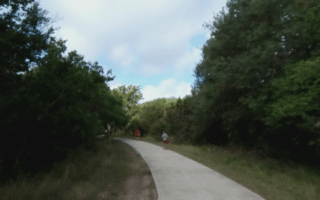
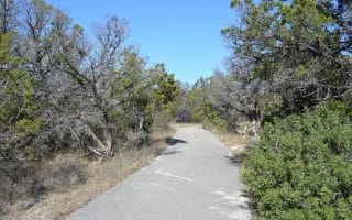
This south section of the River Walk extends for 10 miles from downtown to San Antonio Missions Natural Historical Park. The first ~4 miles are pleasantly green. South of I-10, the trail becomes more open & prairie-like, passing several parks and 18th-century missions. There are numerous additional trails in the Mission Reach section. Key sites, landmarks along the way, from our route map:
Mile 2: King William District (nice residential area) & Southtown
Mile 3: Roosevelt Park
Mile 4.3: Concepcion Park & Concepcion Mission
Mile 7: Mission Park/Padre Park & Mission San Jose
Mile 9.5: Acequia Park
Miles 10-11.5: San Antonio Missions Natural Historical Park; 948-acre park with four 1700s colonial missions, a visitor center & trails.
South of I-10. Google Street View
Add-Ons: See the map for additional sections of the River Walk, and some parks and neighborhoods off the main trail that are fun to explore on foot. The King William neighborhood has some nice streets and interesting homes. At the south end, see the Mission Reach/Medina River Trail route for more running options. At the north end, additional trails in Brackenridge Park.
The San Antonio River Walk is both a major visitor attraction and a great place to run. In the early 20th century, a flood along the San Antonio River caused massive damage to the area. In the years that followed, efforts were made to prevent the flooding including the construction of the Olmos Dam and a bypass channel. Over time, the River Walk was constructed, revitalizing the San Antonio downtown area. Today, the River Walk is a major attraction, with many historical sites located along the route, plus a festive scene of boat tours, bars, restaurants, and hotels. RIVER WALK INFO
Overall, the River Walk is about 15 miles, between the San Antonio Zoo to the north and the Mission Espada/I-410 in the south. It’s paved the entire way. There are three distinct sections: downtown loop in the Alamo area; River Walk North/Museum Reach; and the South (Mission Reach) section, which passes several parks and 18-century missions. The path is mainly paved, there are mile markers, and there are many parts that have trails on both sides of the river. There are some tributary trails coming off the River Walk, and a couple of on-road sections. This TRAIL MAP shows all the trail sections and the key sites along the way. From downtown/Alamo area, the path extends ~4.5 miles north and ~10 miles south. We’ve created two route maps: Downtown loop & South; and from Downtown North.
Downtown Loop (1-1.5 miles)
There’s also a 1 mile loop section of the River Walk in downtown San Antonio that comes off the main north-south flow of the San Antonio River. This is the most ‘touristy’ area. See the Alamo, Tower of the Americas, Convention Center, Briscoe Western Art Museum, & San Fernano Cathedral. The path is mainly below the road grade.
North Section (~5 miles)
From Alamo Plaza, the north section, known as the River Walk Expansion/Museum Reach. Running north and mostly below the road grade in the sections closest to downtown, the route will take you past Hugman Dam, Alamo Mills Dam, the San Antonio Museum of Art, and across the convergence of the many metroways crossing the city. The northern 2 miles is in the area of Brackenridge Park, where there are some additional trails. There’s an on-road section along Avenue B, skirting the edge of Brackenridge Golf Course.
South Section & Mission Reach Trails (~10 miles)
This south section of the River Walk extends for 10 miles from downtown to San Antonio Missions Natural Historical Park. The first ~4 miles are pleasantly green. South of I-10, the trail becomes more open & prairie-like, passing several parks and 18th-century missions. There are numerous additional trails in the Mission Reach section. Key sites, landmarks along the way, from our route map:
Mile 2: King William District (nice residential area) & Southtown
Mile 3: Roosevelt Park
Mile 4.3: Concepcion Park & Concepcion Mission
Mile 7: Mission Park/Padre Park & Mission San Jose
Mile 9.5: Acequia Park
Miles 10-11.5: San Antonio Missions Natural Historical Park; 948-acre park with four 1700s colonial missions, a visitor center & trails.
South of I-10. Google Street View
Add-Ons: See the map for additional sections of the River Walk, and some parks and neighborhoods off the main trail that are fun to explore on foot. The King William neighborhood has some nice streets and interesting homes. At the south end, see the Mission Reach/Medina River Trail route for more running options. At the north end, additional trails in Brackenridge Park.
Scroll Down For Route Maps
Essentials
Trail overall is ~15 miles. Choose a section & see our 'north' & 'south' routes
Fairly flat. South secion is a modest downhill headed south
Downtown/Alamo area. Many other possible start & access points
A 5.5-mile tour of San Antonio’s downtown highlights: River Walk, Market Square, the UT San Antonio, Tower of the Americas, Blue Star Arts Complex, & the Alamo. Good add-on options.
The best San Antonio residential neighborhoods are the adjacent Alamo Heights, Terrell Hills, and Olmos Park, just north of downtown. King William and Mahncke Park are fun and central. Stone Oak, north of the city, is also good for running.
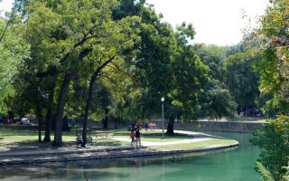
Part of the northern section of the River Walk. Popular, 350 acre park and home to the Japanese Tea Gardens, Botanical Garden, and the San Antonio Zoo. Part of the River Walk or ~3.5 miles of trails within the park. Running track @Alamo Stadium, just across from the park.
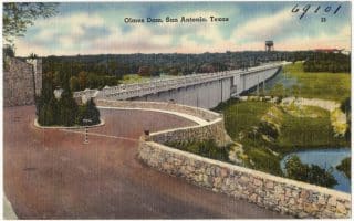
A hilly run topping out at 817 feet, the Olmos Dam allowed for the renovation and restoration of the San Antonio River after the great flood in the early 20th century.
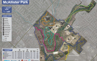
A popular run near San Antonio Airport, McAllister Park features 5 miles of asphalt trails and 10 miles of unpaved natural bicycle and cross-country trails, including “Blue” and “Red” loops.
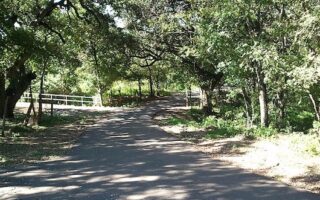
A 28-mile long paved multi-use path in northern San Antonio that can be run in its own right or used to connect several parks. Divided into a northern and southern section. Lovely greenery and some sections with water views.
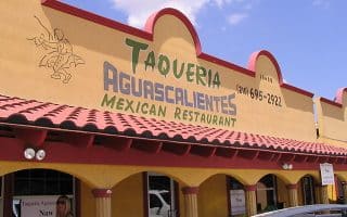
A taste of Hill country close to downtown, near UT San Antonio. This hilly, neighborhood run starts at the popular Hills and Dale biker bar, next to Aguascalientes Taqueria, which is famous for breakfast tacos (do the run first!).
One of the best options for running in northwestern San Antonio. We've mapped a favorite 6-mile section, from Bandera Rd. north to Highway 53, just east of UT San Antonio, passing through several parks.
A lovely long-distance multi-use trail in the south part of San Antonio. Mainly wooded, paved trail runs for 18 miles southwest along the Medina River (not a lot of water views), featuring lovely oak, cypress, and pecan trees. Connects to River Walk at north end.
Share your feedback on this route and see that of other Great Runs users. Click on the image icon to upload a photo. And please let us know if there are notes or changes we should incorporate!
Subscribe
0 Comments
Oldest
Newest
Inline Feedbacks
View all comments
Essentials
Trail overall is ~15 miles. Choose a section & see our 'north' & 'south' routes
Fairly flat. South secion is a modest downhill headed south
Downtown/Alamo area. Many other possible start & access points
 This south section of the River Walk extends for 10 miles from downtown to San Antonio Missions Natural Historical Park. The first ~4 miles are pleasantly green. South of I-10, the trail becomes more open & prairie-like, passing several parks and 18th-century missions. There are numerous additional trails in the Mission Reach section. Key sites, landmarks along the way, from our route map:


Review or Comment on This Route/Share a Photo!
Share your feedback on this route and see that of other Great Runs users. Click on the image icon to upload a photo. And please let us know if there are notes or changes we should incorporate!