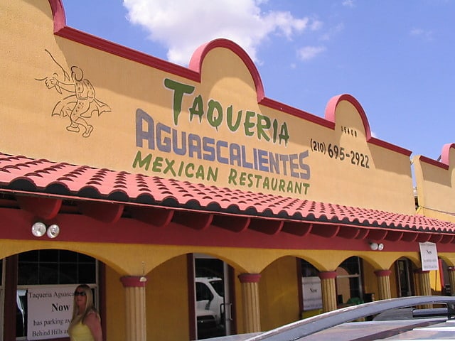
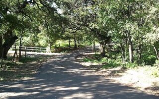
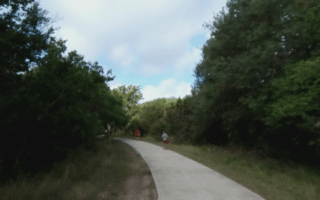
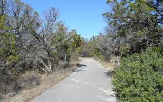
This is a popular combination ‘run and eat’, and a way to get a taste of Hill country not too far from downtown, and near UT San Antonio. The run starts at the well-known Hills and Dale biker bar, next to Aguascalientes Taqueria, which is famous for breakfast tacos (do the run first!). It’s a pleasant and hilly neighborhood run, topping out at High Mountain Road, with great views of San Antonio. A good add-on is to take Babcock Rd. across the highway and enjoy the paths on the campus of the University of Texas at San Antonio. Also, it’s near Six Flags amusement park — drop the kids and go for a run!
Features:
Scroll Down For Route Maps
Essentials
- 3.1 mile loop
- 182 feet
- Hills and Dales Ice House
- 17 miles from downtown
Current Weather & Forecast

San Antonio, US
7:48 pm,
Jun 3, 2026
L: 24°
H: 29°
Daily ForecastHourly Forecast
Tomorrow
4:00 pm
24° / 29°°C
0 mm
0%
17 mph
16 %
1008 mb
0 mm/h
Friday
4:00 pm
24° / 41°°C
0 mm
0%
23 mph
20 %
1007 mb
0 mm/h
Saturday
4:00 pm
22° / 40°°C
0 mm
0%
25 mph
19 %
1005 mb
0 mm/h
Sunday
4:00 pm
21° / 37°°C
0 mm
0%
23 mph
24 %
1003 mb
0 mm/h
Monday
4:00 pm
20° / 38°°C
0 mm
0%
21 mph
25 %
1008 mb
0 mm/h
Today
10:00 pm
32° / 37°°C
0 mm
0%
17 mph
8 %
1004 mb
0 mm/h
Tomorrow
1:00 am
31° / 34°°C
0 mm
0%
3 mph
8 %
1005 mb
0 mm/h
Tomorrow
4:00 am
26° / 26°°C
0 mm
0%
3 mph
11 %
1006 mb
0 mm/h
Tomorrow
7:00 am
25° / 25°°C
0 mm
0%
4 mph
16 %
1007 mb
0 mm/h
Tomorrow
10:00 am
31° / 31°°C
0 mm
0%
3 mph
12 %
1008 mb
0 mm/h
Tomorrow
1:00 pm
37° / 37°°C
0 mm
0%
5 mph
9 %
1007 mb
0 mm/h
Tomorrow
4:00 pm
41° / 41°°C
0 mm
0%
4 mph
5 %
1003 mb
0 mm/h
Other Routes in San Antonio, TX
A 5.5-mile tour of San Antonio’s downtown highlights: River Walk, Market Square, the UT San Antonio, Tower of the Americas, Blue Star Arts Complex, & the Alamo. Good add-on options.

San Antonio’s signature running trail and a top visitor attraction. There are ~15 continuous miles of paved path and numerous parks & tributary trails. We have a detailed writeup of the numerous sections and major sites, and have mapped 'north' and 'south' routes.
The best San Antonio residential neighborhoods are the adjacent Alamo Heights, Terrell Hills, and Olmos Park, just north of downtown. King William and Mahncke Park are fun and central. Stone Oak, north of the city, is also good for running.
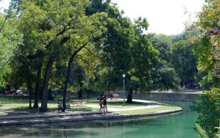
Part of the northern section of the River Walk. Popular, 350 acre park and home to the Japanese Tea Gardens, Botanical Garden, and the San Antonio Zoo. Part of the River Walk or ~3.5 miles of trails within the park. Running track @Alamo Stadium, just across from the park.
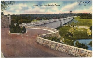
A hilly run topping out at 817 feet, the Olmos Dam allowed for the renovation and restoration of the San Antonio River after the great flood in the early 20th century.
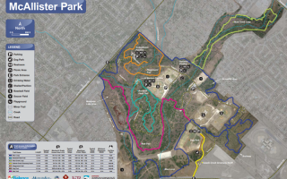
A popular run near San Antonio Airport, McAllister Park features 5 miles of asphalt trails and 10 miles of unpaved natural bicycle and cross-country trails, including “Blue” and “Red” loops.
A 28-mile long paved multi-use path in northern San Antonio that can be run in its own right or used to connect several parks. Divided into a northern and southern section. Lovely greenery and some sections with water views.
One of the best options for running in northwestern San Antonio. We've mapped a favorite 6-mile section, from Bandera Rd. north to Highway 53, just east of UT San Antonio, passing through several parks.
Located just west of the airport, Eisenhower Park has 5 miles of trail runs– but bicycles are not allowed!


A lovely long-distance multi-use trail in the south part of San Antonio. Mainly wooded, paved trail runs for 18 miles southwest along the Medina River (not a lot of water views), featuring lovely oak, cypress, and pecan trees. Connects to River Walk at north end.
User Ratings
Leave A Review or Comment
Review or Comment on This Route/Share a Photo!
Share your feedback on this route and see that of other Great Runs users. Click on the image icon to upload a photo. And please let us know if there are notes or changes we should incorporate!