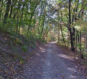
Chickamauga and Chattanooga National Military Park preserves historic battlefields from the Civil War in over 10,000 acres of open space in the Chattanooga area. Chickamauga Battlefield, located 10 miles south of downtown, feautures 50 miles of trail. Lookout Mountain Battlefield, close to downtown, has 30 miles of mainly wooded trails. Note:We don’t recommend running on the Scenic Highway – there’s no shoulder.TRAIL MAP
Some of the best options for running:
From Eagles Nest: Easier running is on the Cravens Terrace Trail. It’s 2 miles one-way (can’t do a full loop). Another good option is the 1 mile along the Old Wauhatchie Pike, which passes by Camp Ross and Mystery Falls. We also like running on the Battlefield Walk & Bike Trail. In fact a good longer run would be do combine Cravens Terrace with Battlefield Walk & Bike Trail, using Cravens Terrace Rd. as a short connector.
From Point Park. Take the incline railway off St. Elmo Ave. to Point Park and enjoy trails near the 2,100-foot summit. After enjoying the great views, good options for running are the Battlefield Walk & Bike Trail, or the more rugged Mountain Beautiful and Bluff Trails.
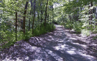
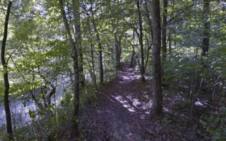
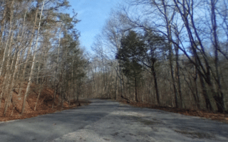
Guild Trail. Google Street View
Another good option is the 1.8 mile Guild Trail. Start at Ruby Falls or the Guild Trailhead off Ochs Hwy. It’s part trail, part paved road (very little traffic).
Chickamauga and Chattanooga National Military Park preserves historic battlefields from the Civil War in over 10,000 acres of open space in the Chattanooga area. Chickamauga Battlefield, located 10 miles south of downtown, feautures 50 miles of trail. Lookout Mountain Battlefield, close to downtown, has 30 miles of mainly wooded trails. Note:We don’t recommend running on the Scenic Highway – there’s no shoulder.TRAIL MAP
Some of the best options for running:
From Eagles Nest: Easier running is on the Cravens Terrace Trail. It’s 2 miles one-way (can’t do a full loop). Another good option is the 1 mile along the Old Wauhatchie Pike, which passes by Camp Ross and Mystery Falls. We also like running on the Battlefield Walk & Bike Trail. In fact a good longer run would be do combine Cravens Terrace with Battlefield Walk & Bike Trail, using Cravens Terrace Rd. as a short connector.
From Point Park. Take the incline railway off St. Elmo Ave. to Point Park and enjoy trails near the 2,100-foot summit. After enjoying the great views, good options for running are the Battlefield Walk & Bike Trail, or the more rugged Mountain Beautiful and Bluff Trails.
Guild Trail. Google Street View
Another good option is the 1.8 mile Guild Trail. Start at Ruby Falls or the Guild Trailhead off Ochs Hwy. It’s part trail, part paved road (very little traffic).
Scroll Down For Route Maps
Essentials
Depends on trail chosen
Some trails are more flat, but generally the area is hilly
Can start at Eagles Nest, Ruby Falls, or at top of Incline Railway
Eagles Nest is off Old Wahautchie Pike. Incline Railway bottom station is off Ochs Hwy.
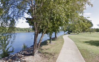
Paved multi-use path is the signature run in Chattanooga. Extends 11 miles from Richmond, through downtown, to the Chickamauga Dam. River views much of the way, numerous sites. Best sections are miles 3-6 and 9-11. Fully lit, markers every 1/2 mile.
A fun and popular run incorporating the Walnut St. pedestrian bridge, Market St. Bridge, and Veteran's bridge, with a loop around Coolidge & Renaissance parks. Add-on with Tennessee River path for a longer run.
Some hill and trail running right near downtown! Hilly trails of 92-acre Stringers Ridge range in difficulty. Enjoy a loop of the trails. To access from downtown, combine with a loop of Coolidge Park and Reservoir Park and the downtown bridges.
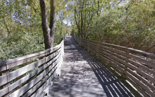
Another great option for a longer off-road run in Chattanooga. The multi-use trail and boardwalk runs parallel to the creek through the middle of metropolitan Chattanooga. There are two segments, separated by a 3-mile gap.
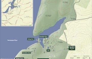
The TVA's largest hydroelectric facility is also one of Chattanooga's running gems. For road running, enjoy the scenic 4.6-mile Reservoir Loop. There are also 22 miles of trails, with varying levels of difficulty. Only 15 minutes from downtown.
A memorable running experience. At Chickamauga Battlefield, there are 50 miles of trails, most suitable for running. We've also mapped a 4-mile loop along quiet park roads featuring a bike lane. Great views, historic sites, very scenic!
This route follows the course of the poplar Chattanooga Chase 8k Course through one of Chattanooga's nicest neighborhoods. Attractive homes, great views of the city & river, a section along the Chattanooga Golf Club, and lovely oak trees.
Part of the Chickamaugua and Chattanooga Military Park system, located near downtown. Run the historic Brown's Ferry Federal Rd. Trail or the Blue Blazes Trail, or combine the two for a 5.8 mile run.
Decent spot for some trail running in this 130-acre preserve on South Chickamauga Creek. There are 5 miles of trails, mainly on a loose sandy soil surface. Some easier, flatter sections and some hillier spots.
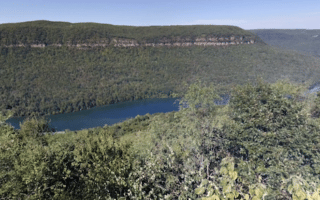
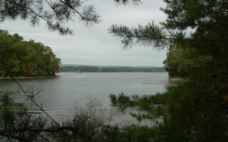
Nice spot for some trail running located on Chickamaugua Lake and the Tennessee River, 13 miles east of downtown. About 10 miles of mainly wooded trails. Outer Loop Trail is 3.9 miles. Go for a post-run dip in the Olympic-sized pool!
A worth-it destination for trail running. 2,800-acre park is located 17 miles northeast of downtown, featuring 10 miles of wooded trails for those on foot. Trails are at moderately challenging and hilly. Some good road running options too.
One of our preferred spots for a trail run in the Chattanooga area. The 4.1 mile Bay Point Loop Trail is an easy-to-follow loop, mainly wooded with occasional water views. Generally good footing and not too hilly.
Share your feedback on this route and see that of other Great Runs users. Click on the image icon to upload a photo. And please let us know if there are notes or changes we should incorporate!
Subscribe
0 Comments
Oldest
Newest
Inline Feedbacks
View all comments
Essentials
Depends on trail chosen
Some trails are more flat, but generally the area is hilly
Can start at Eagles Nest, Ruby Falls, or at top of Incline Railway
Eagles Nest is off Old Wahautchie Pike. Incline Railway bottom station is off Ochs Hwy.


Review or Comment on This Route/Share a Photo!
Share your feedback on this route and see that of other Great Runs users. Click on the image icon to upload a photo. And please let us know if there are notes or changes we should incorporate!