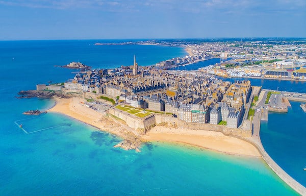
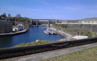
There’s some very nice running in Saint-Malo, combining a path along the walls, waterfront paths, and extensive marina. Saint-Malo is a port city in northwestern France, known for its tall granite walls surrounding the town, and the location for ferries to Plymouth & Portsmouth, UK. Use our mapped route as a guideline for several ‘sections’, or do the full ~10.5 km run!
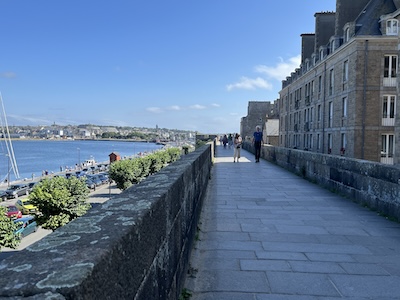
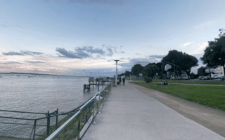
Saint-Malo city walls. Mark LowensteinSillon Beach & Waterfront Path. Google Street View
Waterfront Path: For an 8.5k out and back run, start at the iconic Bastion de la Hollande, and run for 0.5 km out the pier (Môle Des Noires) to the lighthouse. The next section is a path on the outside of the old city walls above the water for 1 km. Then, join the waterfront path along Sillon Beach (Ch. de Sillon/Digue de Rochebonne) for 2.5 km to the end of the beach (beach also runnable). Retrace your steps. At the 8 km mark, we use the Quai Saint-Louis as an option for the return. Marina Add-On: This section adds 2 km out & back around the marina. At the end of Quai Saint-Louis, continue past the rotary on Chau. Eric Tabarly for 0.5 km, and join the path along the Bas Sablons marina and beach. Nice boats and great views! There are optional additional paths around the 39-45 Memorial and leading out to the Maréegraphe scenic viewpoint.
Add-Ons:
At low tide, it can be a treat to run the path out to Grand Bé & Fort National.
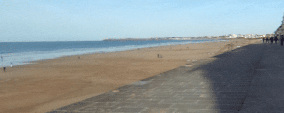
The ~2.5 km Sillon beach is also runnable, with good firm sand. Note tides are significant in this area.
There are also charming, historic streets inside the city walls. They can be very crowded — but are a treat if you’re up early.
There’s some very nice running in Saint-Malo, combining a path along the walls, waterfront paths, and extensive marina. Saint-Malo is a port city in northwestern France, known for its tall granite walls surrounding the town, and the location for ferries to Plymouth & Portsmouth, UK. Use our mapped route as a guideline for several ‘sections’, or do the full ~10.5 km run!
Saint-Malo city walls. Mark LowensteinSillon Beach & Waterfront Path. Google Street View
Waterfront Path: For an 8.5k out and back run, start at the iconic Bastion de la Hollande, and run for 0.5 km out the pier (Môle Des Noires) to the lighthouse. The next section is a path on the outside of the old city walls above the water for 1 km. Then, join the waterfront path along Sillon Beach (Ch. de Sillon/Digue de Rochebonne) for 2.5 km to the end of the beach (beach also runnable). Retrace your steps. At the 8 km mark, we use the Quai Saint-Louis as an option for the return. Marina Add-On: This section adds 2 km out & back around the marina. At the end of Quai Saint-Louis, continue past the rotary on Chau. Eric Tabarly for 0.5 km, and join the path along the Bas Sablons marina and beach. Nice boats and great views! There are optional additional paths around the 39-45 Memorial and leading out to the Maréegraphe scenic viewpoint.
Add-Ons:
At low tide, it can be a treat to run the path out to Grand Bé & Fort National.
The ~2.5 km Sillon beach is also runnable, with good firm sand. Note tides are significant in this area.
There are also charming, historic streets inside the city walls. They can be very crowded — but are a treat if you’re up early.
Scroll Down For Route Maps
Essentials
Full run including waterfront & marina is ~10.5 km (6.5 miles). Can also be divided into sections
Generally flat, except for some elevation around the city walls
Some terrific running options in Brittany's capital city. We've put together a tour of central Rennes, including three notable parks, and routes on paths along the Vilaine River east to Champagne Park and south to the Apigné Lakes.
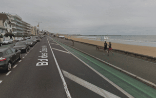
Some terrific running in this small coastal city in southeast Brittany. A highlight is the waterfront promenade, extending for several km, part of Ch. Douaniers. We also love running in Parc Paysage, and the 3.6 km loop around Bois Joalland Lake.
Long, flat run on waterfront promenade for up to 7.6 km between Pornichet and Le Pouliguen. The beach is also very runnable. In Le Pouliguen, there's also some nice running along the Quai around the marina.
A scenic loop around Le Croisic, a peninsula sticking out into the Bay of Biscay. A gravel path on the water side with good footing parallels the main road, offering scenic views the whole way. Full loop is 9.3 km, but can be shortened by ~1 km at the end.
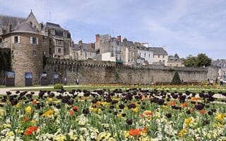
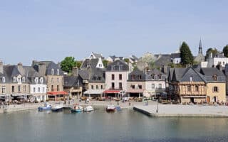
A scenic running tour of the walled town of Vannes, combining some historic sites, parks, quai-side paths along La Marle, and a jaunt out to L'Île de Conleau.
A nice run along Quai-side paths along the Auray River (Rivière d'Auray). Includes the historic Pont de Saint-Goustan (bridge), and a jaunt around the historic center to the Église Saint-Gildas. Nice water views, and colorful homes.
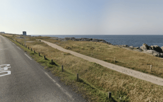
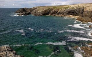
The west side of the Quiberon peninsula -- known as the Côte Sauvage -- is one of the most spectacular places for a run in Brittany. A gravel path runs atop the cliffs alongside the road, among dunes and shrubland, with great water views. Gorgeous at sunset!
In the seaport town of Lorient, two decent running options: a series of paths along the Scorff River, including a loop around Parc du Bois du Château; and the Voie Verte des Kaolins, a multi-use path winding through the countryside toward Plomeur.
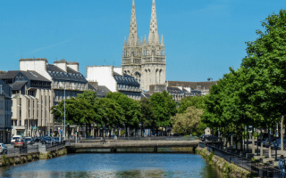
Nice running options along both banks of the Odet River in this Brittany town known for its half-timbered houses, Quimper Cathedral, Breton museums, and faience pottery. We've created routes along the east and west banks, including Prom. du Mont Frugy.
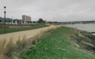
Some lovely running in Brest: a series of waterfront paths extending east to Pointe Saint-Georges; a 2.8 km path through the Botanical Gardens; and lovely, wooded trails in the nearby Bois de Kéroual
One of the best sections for coastal path running in Brittany. A continuous gravel path, flat with good footing, runs above the cliffs alongside the D127 road. Wonderful views of the crashing waves below and a great option at sunset. More of a trail run.
One of the more scenic coastal routes in Brittany, famous for the 'pink cliffs'. This section of the Sentier des Douaniers is an easy-ish trail run. Wonderful views! See our route notes for important tips.
Car-free island located a short ferry ride from the mainland is special to visit and special for running. 35+ km of paved & gravel paths around rolling farmland terrain, lighthouses, historic churches, a water mill. Wonderful variety & views.
A unique & scenic running experience in Brittany! In Saint-Jacut-de-la-Mer, run along a tidal flat to the Ébihens Archipelago, an island with scenic paths out to a viewpoint. Can only be done at low tide. Tidal flats section surface can vary.
A favorite run in Brittany becuause of the great water views from 70m high, and the option to run on a dedicated multi-use path or 'trail run' on the coastal trail.
This route in Dinard has it all: historic aristocratic villas, a charming old town, breathtaking views of the sea and the walled city of Saint-Malo, and a festive beach. Up to 4.5 km one-way, with good add-on options.
Home to one of the largest marshes in France. While much of the park can be explored by boat through the canals and flooded plains, there are some wonderful quiet roads and paths in the park as well. The interactive map is a good resource.
Share your feedback on this route and see that of other Great Runs users. Click on the image icon to upload a photo. And please let us know if there are notes or changes we should incorporate!
Subscribe
0 Comments
Oldest
Newest
Inline Feedbacks
View all comments
Essentials
Full run including waterfront & marina is ~10.5 km (6.5 miles). Can also be divided into sections
Generally flat, except for some elevation around the city walls


Review or Comment on This Route/Share a Photo!
Share your feedback on this route and see that of other Great Runs users. Click on the image icon to upload a photo. And please let us know if there are notes or changes we should incorporate!