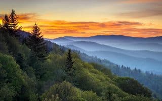
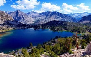
The world’s first national park. Yellowstone National Park showcases colorful hot springs, mudpots, and geysers, in addition to its dramatic mountains, forests, lakes and wildlife. This park is located primarily in the U.S. state of Wyoming, although it also extends into Montana and Idaho. It is the centerpiece of the Greater Yellowstone Ecosystem, the largest remaining nearly-intact ecosystem in the Earth’s northern temperate zone. Hundreds of species of mammals, birds, fish and reptiles have been documented, including several that are either endangered or threatened. The vast forests and grasslands also include unique species of plants. Grizzly bears, wolves, and free-ranging herds of bison and elk live in the park. Paved roads provide close access to the major geothermal areas as well as some of the lakes and waterfalls.
NOTE: Yellowstone is bear country, so special safety measures must be taken. Running is different than walking or hiking. When you encounter a bear at running speed, they are more likely to feel threatened. We talked extensively with Yellowstone National Park Rangers, and although there are some wonderful running routes within the park, they are very concerned about visitor and bear safety. Overall, Park Rangers advise against running in the park. If you are going to run, it is recommended to run in groups, make noise going around corners, carry bear spray, and choose trails that are open with good visibility (like the ones featured below). Before your first run or hike, check in at a Visitors Center or Ranger Station to learn about the current bear activity.
Yellowstone climate is greatly influenced by altitude, with lower elevations generally found to be warmer year round. During the summer months of June through early September, daytime highs are normally in the 70 to 80 °F range, while night time lows can go to below freezing. Summer afternoons are frequently accompanied by thunderstorms. Spring and fall temperatures range between 30 and 60 °F with nights in the teens to single digits. Winter in Yellowstone is accompanied by high temperatures usually between zero and 20 °F and nighttime temperatures below 0 °F for most of the winter. There’s lots of snow.
Yellowstone has five entrance stations: the North Entrance located near Gardiner, MT., the West Entrance near West Yellowstone, MT., the East Entrance near Cody, WY., the South Entrance near Jackson, WY., and the Northeast Entrance near Silver Gate and Cooke City, MT. Make sure to carefully read about access at each station at different times of year.
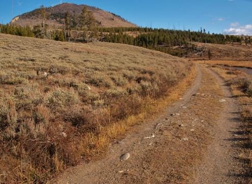
** NEW: Yellowstone Shortline Trail.8.75 miles, 503 foot gain headed west. Asphalt Surface. This paved rail-trail, opened in 2024, is a great addition for runners accessing Yellowstone NP from the west entrance. The trail is mainly wooded, surrounded by pine trees, as it heads for nearly 9 miles west, terminating near the Idaho border. The first half is flat, and the final 3 miles feature a steady climb of nearly 500 feet. There, it’s possible to continue onto the Railroad Right of Way Trail. This is a terrific running option for those staying in West Yellowstone. TRAIL INFORMATIONROUTE MAP
Riverside Trail Loop. 10 km, 132 foot gain. MAP. One of most runnable trails in Yellowstone NP. Gorgeous, flat trail with good footing along the Madison River. Safe and bear free! Easy access from West Yellowstone off Boundary St. Popular for X-C skiing in winter.
Dead Dog Trail. ~3-4 miles, fairly flat.ROUTE MAP. Another good, flat option.
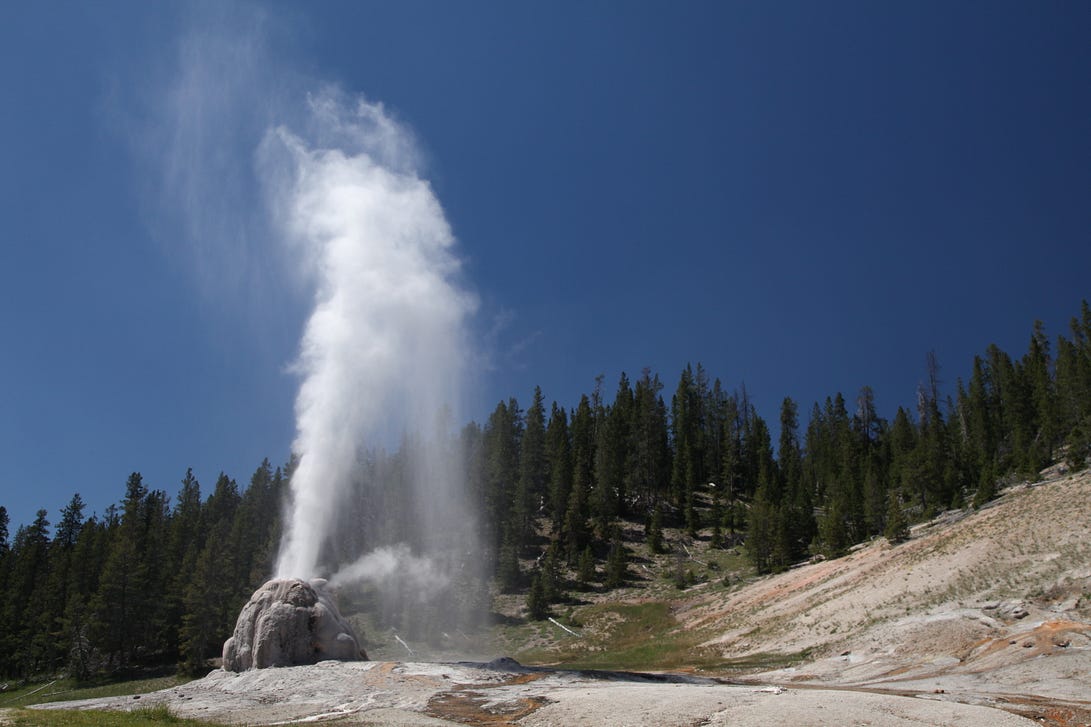
This is the must-do run in Yellowstone. But go early or late to beat the crowds (and be able to run!) The largest concentration of geysers in the world is in the Upper Geyser Basin. It is famous for hosting Old Faithful Geyser, but there is much more in the area than just this famous geyser. Start your run by watching Old Faithful erupt (happening about every 90 minutes). From here, take the paved Continental Divide Trail. Along your way, you will be distracted by the many bubbling and erupting geysers. As the path turns to gravel, you will arrive at Morning Glory Pool. This is a long favored destination for park visitors, Morning Glory Pool was named in the 1880s for its remarkable likeness to its namesake flower. Continue along to pass through a parking lot and onto a short boardwalk showcasing pools, springs and geysers. Take a left after West Geyser to return to the start on the Continental Divide Trail.
Visiting a geyser is one of the must do activities at Yellowstone. This route takes you on a flat formerly paved service road to Lone Star Geyser. Before your run, get the geyser’s eruption schedule from the Old Faithful Visitor Center and time your run so you arrive for an eruption (a plume of water and steam 45 feet tall). Starting from the Kepler Cascades parking area, follow Lone Star Trail for 2.4 miles over the Firehole River, through the forest and several meadows. Enjoy the show, then turn around and follow the road back to the trailhead. In the summer, this trail can get crowded. Run in the morning or late afternoon to avoid the heat and the crowds.
Canyon Junction Area
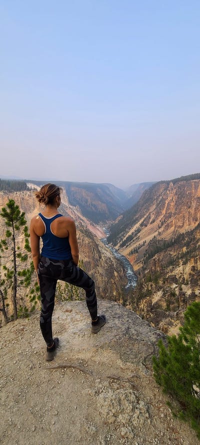
View from South Rim. Aurélie Vilmer
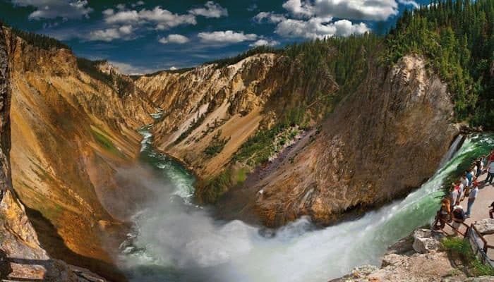
South Rim Trail. 7 miles out and back to Ribbon Lake, 550 foot gain. ROUTE MAP. One of the most scenic and runnable trails in Yellowstone. Partially paved, relatively little traffic. Great canyon views, lakes, thermal features. Start from the trailhead at the end of S. Rim Dr. Run for 1 mile to the Upper Falls View, then head back along the main trail to Ribbon Lake. Mainly an out and back, but a 1 mile diversion to Artists Point is possible. Note: Bring bear spray! Thanks to ************@***il.com” data-hovercard-owner-id=”160″>Aurélie Vilmer for this route!
Sour Creek Trail. 5.1 miles out and back. 400 foot gain. A moderate trail run, not far from canyon village. PRO TIP: Beautiful wildflowers.
Fishing Bridge Area
Storm Point
2.3 mile loop Start: Storm Point Trail Parking MAP
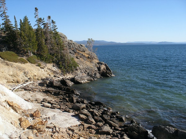
This exciting loop is full of attractions. Beginning at Storm Point Trail parking area, follow the well maintained dirt path towards Indian Pond. As you approach the pond, keep your eyes peeled for buffalo and waterfowl. If you encounter any buffalo, give them a wide berth. Although peaceful in appearance, they are very dangerous. As you continue on, you will get to Yellowstone Lake and enjoy panoramic views. The path parallels the shore until your reach Storm Point (an area known for it’s yellow-bellied marmots population). At Storm Point, take a moment to enjoy your nearly 360 degree view of Yellowstone Lake along with all the animal activity it attracts. From here, the route continues along the lake shore a short distance before looping back to the right and entering the forest. It eventually breaks out of the forest and rejoins the trail near the trailhead. This route is great for its even elevation and scenic views but can get busy during the day. Time your run for the morning or evening to find seclusion on your run.
Mammoth Hot Springs Area
Bunsen Peak
5.3 miles one-way Start: Old Bunsen Peak Road Trail MAP
Bunsen Peak is a prominent peak due south of Mammoth Hot Springs. A flat dirt road perfect for running goes around the base of Bunsen Peak. Follow the road through new growth lodgepole forest and open areas with expansive views for about 2 miles. Turn around here for a great flat 4 mile out-and-back. If you are up for a longer adventure, continue along the road. From here, it circles the peak to the east and north traveling downhill for another 3 miles until it reaches the main road. To get back to your starting point, run back up the trail the same way you came.
Rescue Creek Trail
3 mile out-and-back Start: Rescue Creek Trailhead
http://www.trailguidesyellowstone.com/
Begin at the Rescue Creek Trailhead off of route 89. As you begin your run, cross a large footbridge and up a slight hill to an open expanse with a defined double track. When you need a break, turn around to get views of Electric Peak and Sepulcher Mountain.
About a mile and a half in, the trail enters a notch at the base of Rattlesnake Butte and rises steeply for about 0.3 of a mile and 200 ft. Before this climb is a great place for a 3 mile out-and-back route.
You can also run from the opposite end at the Blacktail Plateau Trailhead. Begin on the Blacktail Deer Creek Trail, then veer left onto the Rescue Creek Trail. Enjoy the scenery as you run through a sagebrush meadow. After about 3 miles you will have reached the highest point on the trail. We recommend turning around here for an enjoyable 6 mile out-and back
Video Highlights: Main Park Road and Geysers (17 min.)
The world’s first national park. Yellowstone National Park showcases colorful hot springs, mudpots, and geysers, in addition to its dramatic mountains, forests, lakes and wildlife. This park is located primarily in the U.S. state of Wyoming, although it also extends into Montana and Idaho. It is the centerpiece of the Greater Yellowstone Ecosystem, the largest remaining nearly-intact ecosystem in the Earth’s northern temperate zone. Hundreds of species of mammals, birds, fish and reptiles have been documented, including several that are either endangered or threatened. The vast forests and grasslands also include unique species of plants. Grizzly bears, wolves, and free-ranging herds of bison and elk live in the park. Paved roads provide close access to the major geothermal areas as well as some of the lakes and waterfalls.
NOTE: Yellowstone is bear country, so special safety measures must be taken. Running is different than walking or hiking. When you encounter a bear at running speed, they are more likely to feel threatened. We talked extensively with Yellowstone National Park Rangers, and although there are some wonderful running routes within the park, they are very concerned about visitor and bear safety. Overall, Park Rangers advise against running in the park. If you are going to run, it is recommended to run in groups, make noise going around corners, carry bear spray, and choose trails that are open with good visibility (like the ones featured below). Before your first run or hike, check in at a Visitors Center or Ranger Station to learn about the current bear activity.
Yellowstone climate is greatly influenced by altitude, with lower elevations generally found to be warmer year round. During the summer months of June through early September, daytime highs are normally in the 70 to 80 °F range, while night time lows can go to below freezing. Summer afternoons are frequently accompanied by thunderstorms. Spring and fall temperatures range between 30 and 60 °F with nights in the teens to single digits. Winter in Yellowstone is accompanied by high temperatures usually between zero and 20 °F and nighttime temperatures below 0 °F for most of the winter. There’s lots of snow.
Yellowstone has five entrance stations: the North Entrance located near Gardiner, MT., the West Entrance near West Yellowstone, MT., the East Entrance near Cody, WY., the South Entrance near Jackson, WY., and the Northeast Entrance near Silver Gate and Cooke City, MT. Make sure to carefully read about access at each station at different times of year.
** NEW: Yellowstone Shortline Trail.8.75 miles, 503 foot gain headed west. Asphalt Surface. This paved rail-trail, opened in 2024, is a great addition for runners accessing Yellowstone NP from the west entrance. The trail is mainly wooded, surrounded by pine trees, as it heads for nearly 9 miles west, terminating near the Idaho border. The first half is flat, and the final 3 miles feature a steady climb of nearly 500 feet. There, it’s possible to continue onto the Railroad Right of Way Trail. This is a terrific running option for those staying in West Yellowstone. TRAIL INFORMATIONROUTE MAP
Riverside Trail Loop. 10 km, 132 foot gain. MAP. One of most runnable trails in Yellowstone NP. Gorgeous, flat trail with good footing along the Madison River. Safe and bear free! Easy access from West Yellowstone off Boundary St. Popular for X-C skiing in winter.
Dead Dog Trail. ~3-4 miles, fairly flat.ROUTE MAP. Another good, flat option.
This is the must-do run in Yellowstone. But go early or late to beat the crowds (and be able to run!) The largest concentration of geysers in the world is in the Upper Geyser Basin. It is famous for hosting Old Faithful Geyser, but there is much more in the area than just this famous geyser. Start your run by watching Old Faithful erupt (happening about every 90 minutes). From here, take the paved Continental Divide Trail. Along your way, you will be distracted by the many bubbling and erupting geysers. As the path turns to gravel, you will arrive at Morning Glory Pool. This is a long favored destination for park visitors, Morning Glory Pool was named in the 1880s for its remarkable likeness to its namesake flower. Continue along to pass through a parking lot and onto a short boardwalk showcasing pools, springs and geysers. Take a left after West Geyser to return to the start on the Continental Divide Trail.
Visiting a geyser is one of the must do activities at Yellowstone. This route takes you on a flat formerly paved service road to Lone Star Geyser. Before your run, get the geyser’s eruption schedule from the Old Faithful Visitor Center and time your run so you arrive for an eruption (a plume of water and steam 45 feet tall). Starting from the Kepler Cascades parking area, follow Lone Star Trail for 2.4 miles over the Firehole River, through the forest and several meadows. Enjoy the show, then turn around and follow the road back to the trailhead. In the summer, this trail can get crowded. Run in the morning or late afternoon to avoid the heat and the crowds.
Canyon Junction Area
View from South Rim. Aurélie Vilmer
South Rim Trail. 7 miles out and back to Ribbon Lake, 550 foot gain. ROUTE MAP. One of the most scenic and runnable trails in Yellowstone. Partially paved, relatively little traffic. Great canyon views, lakes, thermal features. Start from the trailhead at the end of S. Rim Dr. Run for 1 mile to the Upper Falls View, then head back along the main trail to Ribbon Lake. Mainly an out and back, but a 1 mile diversion to Artists Point is possible. Note: Bring bear spray! Thanks to ************@***il.com” data-hovercard-owner-id=”160″>Aurélie Vilmer for this route!
Sour Creek Trail. 5.1 miles out and back. 400 foot gain. A moderate trail run, not far from canyon village. PRO TIP: Beautiful wildflowers.
Fishing Bridge Area
Storm Point
2.3 mile loop Start: Storm Point Trail Parking MAP
This exciting loop is full of attractions. Beginning at Storm Point Trail parking area, follow the well maintained dirt path towards Indian Pond. As you approach the pond, keep your eyes peeled for buffalo and waterfowl. If you encounter any buffalo, give them a wide berth. Although peaceful in appearance, they are very dangerous. As you continue on, you will get to Yellowstone Lake and enjoy panoramic views. The path parallels the shore until your reach Storm Point (an area known for it’s yellow-bellied marmots population). At Storm Point, take a moment to enjoy your nearly 360 degree view of Yellowstone Lake along with all the animal activity it attracts. From here, the route continues along the lake shore a short distance before looping back to the right and entering the forest. It eventually breaks out of the forest and rejoins the trail near the trailhead. This route is great for its even elevation and scenic views but can get busy during the day. Time your run for the morning or evening to find seclusion on your run.
Mammoth Hot Springs Area
Bunsen Peak
5.3 miles one-way Start: Old Bunsen Peak Road Trail MAP
Bunsen Peak is a prominent peak due south of Mammoth Hot Springs. A flat dirt road perfect for running goes around the base of Bunsen Peak. Follow the road through new growth lodgepole forest and open areas with expansive views for about 2 miles. Turn around here for a great flat 4 mile out-and-back. If you are up for a longer adventure, continue along the road. From here, it circles the peak to the east and north traveling downhill for another 3 miles until it reaches the main road. To get back to your starting point, run back up the trail the same way you came.
Rescue Creek Trail
3 mile out-and-back Start: Rescue Creek Trailhead
http://www.trailguidesyellowstone.com/
Begin at the Rescue Creek Trailhead off of route 89. As you begin your run, cross a large footbridge and up a slight hill to an open expanse with a defined double track. When you need a break, turn around to get views of Electric Peak and Sepulcher Mountain.
About a mile and a half in, the trail enters a notch at the base of Rattlesnake Butte and rises steeply for about 0.3 of a mile and 200 ft. Before this climb is a great place for a 3 mile out-and-back route.
You can also run from the opposite end at the Blacktail Plateau Trailhead. Begin on the Blacktail Deer Creek Trail, then veer left onto the Rescue Creek Trail. Enjoy the scenery as you run through a sagebrush meadow. After about 3 miles you will have reached the highest point on the trail. We recommend turning around here for an enjoyable 6 mile out-and back
Video Highlights: Main Park Road and Geysers (17 min.)
Our selection of the 1-2 'must do' runs in the major U.S. national parks. The focus is on the most scenic, safe, and accessible spots for a run, geared toward the everyday runner.
The Park Loop Road is great for running, especially the 5 mile section between Seal Beach and Little Hunters Beach. The Carriage Roads are special for running, with many options. And for a true challenge, run up Cadillac Mountain!
75 miles from Washington, D.C., featuring the famed 105 mile Skyline Drive. Wonderful drive touring and hiking opportunities. Good running options along some of the gentler trails and fire roads. Trail runners will find lots of options here too!
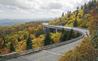
469-mile scenic road features stunning vistas, rugged mountains, and pastoral landscapes. With no shoulder, the Parkway and isn't great for running. We've researched the more runnable hiking trails and also recommend the carriage roads of Moses Cone Park.
America's most visited National Park. A great option for runners is the Cades Cove Loop Road, which runs 11 miles one-way. Also good running in the Greenbrier Cove area. Famous for wildflowers!
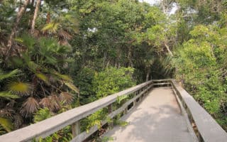
Huge park southwest of Miami with 1.5 million acres of wetland. Some of the best spots for running are the Shark Valley Bike Trail, Pinelands trails, the Old Ingraham Highway Trail and the Flamingo area trails.
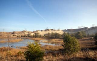
Located only an hour from Chicago, Indiana Dunes National Park is known for its spectacular dunes, wetlands, forests, and beaches. We've researched the best running options among the 50 miles of hiking trails and 37 miles of bike trails.
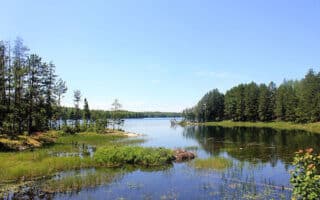
Water-based National Park with a series of interconnected waterways. Some scenic trails for running near the three Visitor Centers, featuring forests, marshes, wetlands, and lakes. Spectacular for running in winter, with trails and "ice roads"!
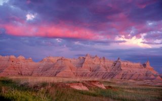
Dramatic landscapes spanning layered rock formations, steep canyons and towering spires. Best spots for running are along the Badlands Loop Scenic Highway, Sage Creek Rim Road, Castle Trail, and Sheep Mountain Table Rd.
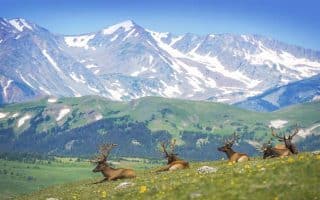
Wonderful park within 90 minutes of Denver. Majestic mountain views, mountain lakes, wooded forests, mountain tundra. Best running options are trails around Cub Lake, Lily Lake,Upper Beaver Meadow, and Emerald Lake.
Park in southwestern Colorado is a glimpse into communities that the Pueblo people built on the mesas and in the cliffs. 30 miles of hiking trails around mesas, and into rugged canyons. Best for running is the 5-mile Long House Loop.
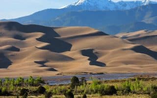
North America's tallest dunes, and terrain that also alpine peaks, forest, grasslands, and wetlands. Running the dunes is a singular experience but also very challenging. Best bet for running in the park are the miles of grasslands trails.
A remote and isolated park, featuring gorgeous mountains, desert, and 120 miles along the Rio Grande River. Best running spots are some of the gentler mountain trails, in the desert, along the river, and some of the park's scenic roads.
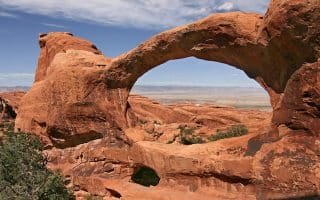
Along with Canyonlands NP, located in the outdoor recreational mecca around Moab, UT. For Arches, we recommend running the Landscape Arch, a nice 2-mile route starting at Devils Garden Trailhead. Arches Scenic Dr. is also runnable.
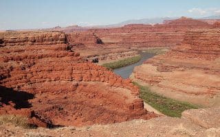
This area, near Moab, is a mecca for biking, hiking, climbing and other adventuring activities. Great running options in Canyonlands are Colorado River Overlook trail, Neck Springs, and a trail along Murphy Point Overlook.
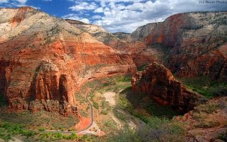
The two best options for running are the Pa’rus Trail, which is a 1.7 mile, flat path skirting the Virgin River in the flat, lower section of Zion Canyon, and the 6.2 miles Scenic Drive from the Visitor Center to Temple of Sinawava.
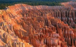
Bryce is marked by the salmon and orange-colored limestone that create a maze of spires, pinnacles and fins. Best running options are the new shared use bike path connecting Bryce and Red Canyon; and the 5.5 mile Rim Trail.
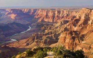
The best running options are in the South Rim section of massive Grand Canyon. Great running along the Rim Trail, the network of Greenways throughout the Village and surrounding communities, and the Arizona National Scenic Trail.
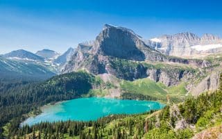
Pristine forests, alpine meadows, glacier-carved peaks, spectacular lakes, wildflowers! Fantastic trail running. We've included some gentler trail running options, plus some multi-use paths just outside the park in Kalispell & Hungry Horse.
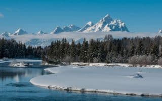
Showcasing the major peaks of the 40-mile-long Teton Range. Best for running in summer. Good options are the Grand Teton multi-use path, Taggart Lake Trail, and 6-mile loop around Two Ocean Lake.
240,000 acre park, 2-hour drive from Seattle. Wonderful running opportunities, around valleys, waterfalls, subalpine meadows, old-growth forest and glaciers. Best routes are along some of the less traveled side roads and gentler hiking trails.
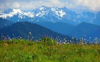
One of the closest national parks to a major metro area, the 1 million acre Olympic National Park has an incredible diversity of terrain, featuring snow-covered mountains, lush rain forests, and dramatic coastal terrain.
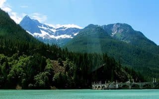
A stunning and diverse alpine landscape, less than three hours from Seattle. Generally it's more challenging trail running. Best running options are in Stekehin, accessed only by ferry. The MUST DO run is the first 6 miles of Stekehin Valley Road.
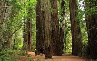
133,000-acre park located near the California-Oregon border features some of the tallest trees on earth, as well as vast prairies, oak woodlands, riverways, and 40 miles of rugged coastline. Our recommendations on the best trails, roads, and beaches for running.
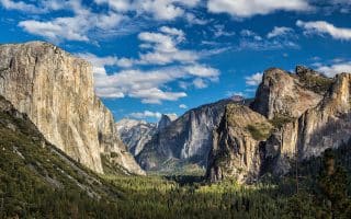
Waterfalls, deep valleys, grand meadows, ancient giant sequoias, a vast wilderness area in this 1,200 square mile park. Two good running options are the Yosemite Village Multi-Use Path, and Tuolumne Meadows.
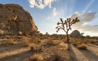
Not one of the better national parks for running, given the rugged, often sandy terrain, and summer heat. Best options are the backcountry roads, some of the easier hiking trails, and quiet residential streets in Yucca Valley & Desert Hot Springs.
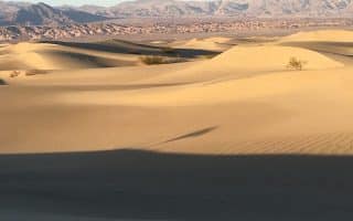
One of the more unique parks in terms of terrain, geography, and extreme weather. Fantastic opportunities for trail running -- though easy to get lost! Some good running options along park roads - sunrise/sunset are best.
Huge mountains, rugged foothills, deep canyons, vast caverns, and the world’s largest trees in these side-by-side parks. Recommended running: Roaring Rivers to Zumwalt Meadows Loop in Kings and Crescent Meadow Trail and Road.
A one-of-a-kind run on a barren volcano, with incredible ocean views. Very challenging 10-mile run to the 10,000-foot summit is 3,000 foot gain. Or, have a partner drop you part way or go up for sunrise and run down.
A one-of-a kind place. Hike or run the rim of an active crater, or run on trails or roads to enjoy terrain that includes deserts and rain forests, past craters and rift zones. We outline several good options. Note trail closures and air quality warnings!
Virgin Islands National Park comprises 60% of the land mass of the St. John in the U.S. Virgin Islands. Numerous trails in the park are good for running, notably the Francis Bay Trail to Leinster Point, the Johnny Horn Trail, and Lind Point Trail.
Share your feedback on this route and see that of other Great Runs users. Click on the image icon to upload a photo. And please let us know if there are notes or changes we should incorporate!


Review or Comment on This Route/Share a Photo!
Share your feedback on this route and see that of other Great Runs users. Click on the image icon to upload a photo. And please let us know if there are notes or changes we should incorporate!